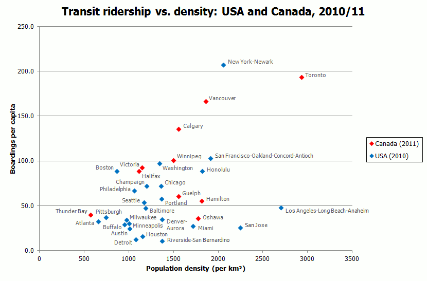
Urban Area                 Population  Area_sqkm   Density   Boardings      Per capita
New York-Newark (NY/NJ/CT) 18,361,295  8936.0      2055      3,806,892,800  207.3
Toronto (ON)               5,132,794   1751.5      2931      992,828,000    193.4
Vancouver (BC)             2,135,201   1150.4      1856      356,218,100    166.8
Calgary (AB)               1,095,404   704.5       1555      148,546,000    135.6
Winnipeg (MB)              671,551     449.8       1493      67,735,000     100.9
Washington (DC/MD/VI)      4,586,770   3423.3      1340      445,170,000    97.1
Victoria (BC)              316,327     277.1       1142      29,377,600     92.9
Boston (MA/NH/RI)          4,181,019   4852.2      862       373,315,000    89.3
Halifax (NS)               297,943     269.3       1106      26,484,200     88.9
Champaign (IL)             145,361     121.5       1196      10,555,900     72.6
Chicago (IL/IN)            8,608,208   6326.7      1361      624,061,500    72.5
Philadelphia (PA/NJ/DE)    5,441,567   5131.7      1060      366,040,700    67.3
Guelph (ON)                122,362     78.9        1552      7,245,000      59.2
Portland (OR/WA)           1,849,898   1358.1      1362      107,359,000    58.0
Seattle (WA)               3,059,393   2616.7      1169      165,639,000    54.1
LA-Long Beach-Anaheim (CA) 12,150,996  4496.3      2702      585,985,300    48.2
Thunder Bay (ON)           102,222     179.4       570       4,134,400      40.4
Pittsburgh (PA)            1,733,853   2344.4      740       65,116,300     37.6
Denver-Aurora (CO)         2,374,203   1730.0      1372      83,455,100     35.2
Atlanta (GA)               4,514,419   6851.4      659       147,862,600    32.8
Minneapolis-StPaul (MN/WI) 2,650,890   2646.5      1002      80,442,000     30.3
Buffalo (NY)               935,906     984.0       951       27,516,200     29.4
Miami (FL)                 5,502,379   3208.0      1715      151,527,400    27.5
Austin (TX)                1,362,416   1354.7      1006      33,860,500     24.9