Northern Light
Superstar
Again w/the over-sized type........
Please stop that. It literally makes it less readable.
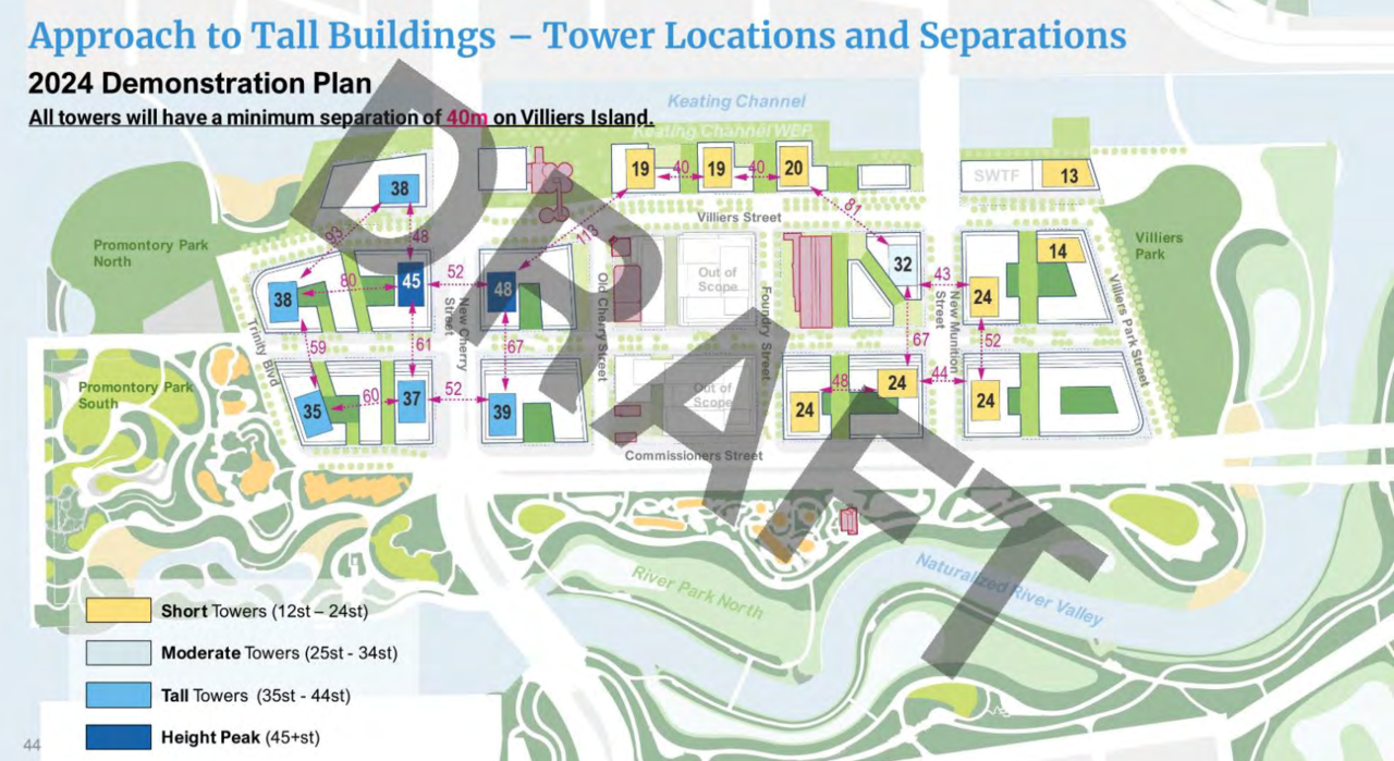
The island is at least 33ha gross. The so-called "developable area," which includes Villiers Park, is roughly 24ha.
There are many design decisions baked into this that deserve scrutiny, especially how much land area is taken up by roads. But also the sizes, orientations and arrangements of buildings; tower separation distances; and assumptions about mode share.
Could you integrate that parking into the design of an existing tower? Sure........but doing so below the water table is not cheap, it's Ontario Place expensive and worse.
Going above grade, has aesthetic implications and increases the height of a tower with 'x'' levels of parking above-grade, below residential. That increases shadowing and wind etc etc. It also means you need the support car capacity wherever those garages exit (likely even wider ROWs)
 but what if...
 ... or is it?

This is a great idea actually!!Forgive me this wacky Blue Sky dreaming moment that can only happen in an alternate universe
1. ignoring the ridiculous expense associated with water table issues and tunnelling
2. sorting egress issues from below, particularly for mobility challenged people
3. a thousand other engineering/logistical/emergency services and financial issues....
.... we put traffic on Centre Street or even Villiers Street below grade (including "street parking" for visitors) ?
We can build towers over subways and parking garages under water... could we keep a street dry below grade and even connect to underground parking $$ along the chosen route?
Say from new Cherry Street east to New Munitions Street... only 600 metres or so?
Absurd to finance I know
Building here is a premium development opportunity... maybe a premium charge/levy (call the bylaw Section 37+ ;-) could help pave the way to an almost fully pedestrianized spine.
Ok I'll shut up now and go back to dreaming stupid stuff.
Forgive me this wacky Blue Sky dreaming moment that can only happen in an alternate universe
1. ignoring the ridiculous expense associated with water table issues and tunnelling
2. sorting egress issues from below, particularly for mobility challenged people
3. a thousand other engineering/logistical/emergency services and financial issues....
.... we put traffic on Centre Street or even Villiers Street below grade (including "street parking" for visitors) ?
We can build towers over subways and parking garages under water... could we keep a street dry below grade and even connect to underground parking $$ along the chosen route?
Absurd to finance I know
Building here is a premium development opportunity... maybe a premium charge/levy (call the bylaw Section 37+ ;-) could help pave the way to an almost fully pedestrianized spine.
Ok I'll shut up now and go back to dreaming stupid stuff.
The only thing is, as people who really want to see this project reach it's fullest potential, simply writing about may not do much in terms of advocacy...maybe it needs to be directed to someone? This is a very broad question to everyone on this thread, but what can we do other than complain about it on this forum? (Not that I don't do the same, in fact I almost always in agreement to criticisms as posted)..
Write to councillors, WT, MPs etc? Maybe if we all get on board somehow the word would get out. That being said, I do leave open the idea that many people support this as there have been many great changes to the port lands so far. Hope to hear from people here, thanks.
"so-called"?
***
This is the block of land under discussion, which excludes non-buildable land because its within the floodplain/natural area, or on flood protection berm. The only area excluded otherwise is a portion of 'the Lake Ontario fronting parkland.
View attachment 561532
This is almost exactly 24.0ha.
But, that includes all interior parks and all bordering streets.
There is no 33ha version of this Island that is buildable.
***
As for questioning assumptions, that's fine.
But I've put my homework on the table.
You can reduce total traffic/roads space by cutting the population density and then reducing the space allocated to cars proportionately.
You can also do that by running a subway to Villiers Island, but we opted for a design that will not have heavy Metro/High capacity Rail linking to it.
Within the existing framework, its certainly possible, as I've noted to 'green' some interior streets, by shifting parking to the perimeter of the site.
But to do this, the parking has to displace something else, if its not the parkland, then its residential development. That's what they did in Merwede and in a couple of other like spots, shifting dedicated parking garages to the edge of the community.
We can do that here, it just has to come at the expense of something else. Could you integrate that parking into the design of an existing tower? Sure........but doing so below the water table is not cheap, its Ontario Place expensive and worse.
Going above grade, has aesthetic implications and increases the height of a tower with 'x'' levels of parking above-grade, below residential. That increases shadowing and wind etc etc. It also means you need the support car capacity wherever those garages exit (likely even wider ROWs)
I'm fine w/all sorts of 'fixes' here.
But virtually all of them impose lower density and lower height, rather than greater.
At 9,000 units/15,000 people on 0.24km2, you get a population density of 60,000 per km2. More than double St. Jamestown.
Even if you took a more a conservative per unit total (1.4) you get 12,600 residents, still on 0.24km2, or more than 50,000
Okay just going to put this out there but somebody with the title above grade telling somebody is a good idea to put everything subterranean just made my day thanks guysThis is a great idea actually!!
I understand it's a big ask, but this is the future of our city! And the last developable parcel of land right near the heart of downtown. I have already voiced these opinions at meetings/feedback sessions. It shouldn't intrinsically be this...boring.Writing to the right people can be helpful. But you do need to know what is you want that is not currently on offer, and propose a means to achieving it.
You can't simply ask for a fairy tale.
So, for instance, as per the suggestion of @3Dementia above. You would like to pedestrianize one of the roads.
This requires the following questions/answers:
1) Where do you proposed to redirect the traffic presumed to used this road? (There are legit answers, but you have to pick one)
2) If that parking provided on-street is deemed necessary for visitors or shoppers, where do you proposed to relocate said parking?
3) Does your change impeded transit?
4) Does your change impede loading access or parking access to a proposed building? How do you proposed to resolve that?
5) How will you accommodate emergency services? (I've already provided that solution above)
6) Does your idea/solution cost more than the existing proposal? If so, where will the additional funding needed come from?
* I will note here, w/o doxing anyone, that people from City Planning and from Waterfront Toronto are members of this forum, so what gets written here is often read by people of influence.
Once you've have your idea formed above, the first people to write to are WT and the people managing this plan. It will always be easiest to make any tweaks at this stage. (though earlier would have been easier still).
When the Plan goes to Committee, (at City Hall) writing to the Committee Chair and/or your councillor if they are on the Committee would be strong choices; and following that, the Mayor.
***
This is the timeline:
View attachment 561592
The intention is to take the zoning component of what's proposed here though Council by the summer break.
But the public realm component is open to refinement even afterwards.
If you want the zoning re-done, it will set the entire project back by at minimum of one quarter (3 months), but maybe longer depending on how drastic the proposed change, as it might require re-modelling everything.
Collingwood is fun. You have a nice lookout to Toronto from that ski hill.Okay just going to put this out there but somebody with the title above grade telling somebody is a good idea to put everything subterranean just made my day thanks guys
I'm
