News   Apr 25, 2024
 298     0 
News   Apr 25, 2024
 944     3 
News   Apr 25, 2024
 987     0 

Rare Maps of Toronto

Well, there's always the possibility that the map is older than the booklet (and older than the 1994 date noted at the side!), or that Rose Hill and Summerhill are being shown on a modern map to give readers a sense of where they used to be.
 
Excellent map! Thanks for sharing.

How old is that booklet? I didn't know there was a period when Summerhill still crossed the ravine (although it seems the railway line separated it into two parts on the west side) after Mt Pleasant had been built through the area.

Here's a photo of Summerhill, showing the railway crossing and the road going down the hill
f1231_it1304.jpg


and here's the bridge - I assume this is looking north and it's the railway bridge in the background
f1231_it1977.jpg
 
Here's a photo of Summerhill, showing the railway crossing and the road going down the hill
and someone by the fence -- waiting for the train to cruise on through (sorry, ac/dc lyrics... couldn't help myself)

and here's the bridge - I assume this is looking north and it's the railway bridge in the background
yes

and this gives clear evidence that mount pleasant road (re)used summerhill's roadbed on the right there
 
Given how difficult it seems for Canada Post to deliver mail accurately even with those codes, I'm sometimes tempted to start writing 'Toronto 6', etc., on envelopes.
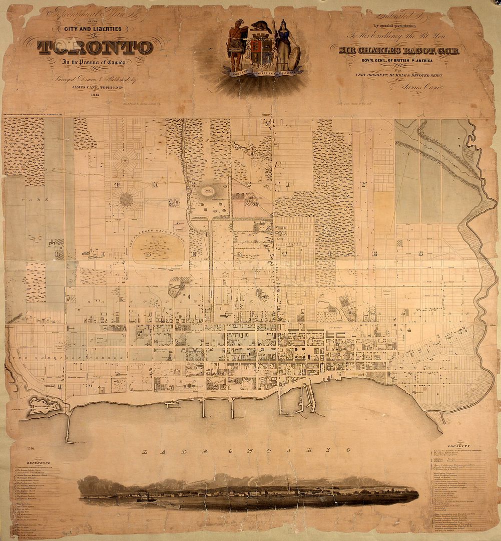
For added complexity, they changed the numbering at somepoint too. See the history section at the wiki below. http://en.wikipedia.org/wiki/Postal_codes_in_Canada

I used to travel with an ancient suitcase my father had written the address on it, including "Toronto 10", years ago. I thought it had a very retro feel to it. Much better than the current M6E.
 
indeed

"young street road" lol

;)

In the 1833-34 York Commercial Directory there is a street listing that has Yonge Street going north from the Bay to Lot Street (Queen Street) but then it is called Yonge Street Road and the houses have no numbers. I assume it was seen as 'street' in the town but in the country became a 'road'. Who knew? (The York Commercial Directory is digitised at TPL website)
 
A great collection of maps here.

This one (1842) is quite fascinating (can be enlarged).

http://maps.library.utoronto.ca/dvhmp/Scans/G_3524_T61_1842.jpg

It will be found along with many other maps at:

http://maps.library.utoronto.ca/dvhmp/maps.html

Perhaps this page has been noted before, but I just discovered it by accident.


Goldie, If you look at one of the maps one that site, it shows the original route of the mystery train track you mentioned (one that i've always tried to follow on google earth) it starts in the don valley, passes through Taylor creek before following the subway alignment through scarborough, interesting stuff.
 
For all the precision that the current complexity is supposed to bring, I still get mail:

-for the same house number on a neighbouring street
-for a different house on the same street
-(and this is the best of all) for a street of the same name on the other side of the city. I live in Toronto, the other street is in North York but the official address there requires 'Toronto' and a completely different postal code. My house number doesn't even exist on the other street. The postal code doesn't help. Time to go back to single digits!
 
A great collection of maps here.

This one (1842) is quite fascinating (can be enlarged).

http://maps.library.utoronto.ca/dvhmp/Scans/G_3524_T61_1842.jpg

It will be found along with many other maps at:

http://maps.library.utoronto.ca/dvhmp/maps.html

Perhaps this page has been noted before, but I just discovered it by accident.

Thanks, Goldie. There's a copy of the 1842 map on the TPL site (in colour), but the U of T site is much better for looking at the wonderful details.

From the TPL site:

maps-r-17-3.jpg


maps-r-17-1.jpg
 
Last edited:
A racecourse, cricket grounds and a cholera hospital. All the things modern Toronto is sorely lacking.
 
Thanks for linking to that. It's interesting that there was an Elm St east of Yonge (and apparently part of a series of streets named for trees there, along with Oak, Cedar, Spruce and Sumach) but it doesn't seem to align with the current Elm west of University.
 

Back
Top