|
|
|


You are using an out of date browser. It may not display this or other websites correctly.
You should upgrade or use an alternative browser.
You should upgrade or use an alternative browser.
Miscellany Toronto Photographs: Then and Now
- Thread starter Mustapha
- Start date
Goldie
Senior Member
Magnificent collection and the technique is outstanding.
You've discovered some gems here.
Thanks Mustapha.
Goldie
Senior Member
Goldie
Senior Member
adma
Superstar
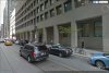
It's the SE corner of the building; that'd be the "Esplanade extension" zone where the GO bus terminal now is on the left. And off to the right, Frank Darling's BMO (now HHoF) can be seen.
Presumably, at best there'd be someplace along the Union Station viaduct across Yonge where a "now" shot can be obtained.
Presumably, at best there'd be someplace along the Union Station viaduct across Yonge where a "now" shot can be obtained.
DSC
Superstar
Member Bio
- Joined
- Jan 13, 2008
- Messages
- 18,724
- Reaction score
- 25,626
- Location
- St Lawrence Market Area
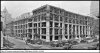
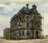
The Dominion Public Building was initially built as the Customs House; Wiki says:
"The Dominion Public Building is a five-storey neoclassical structure built between 1926 to 1935 for the government of Canada at southeast corner of Front and Bay streets in Toronto.[1]
The building was designed by architects Thomas W. Fuller and James H. Craig and originally served as Toronto's federal customs clearing house. It remains a federal property, currently housing a number of administrative and support functions for Canada Revenue Agency."
I too cannot quite see where the archive photo was taken from unless it has been 'flipped" - sure looks like the Royal York in background...
adma
Superstar
I too cannot quite see where the archive photo was taken from unless it has been 'flipped" - sure looks like the Royal York in background...
And again: the BMO/HHoF can be seen at the right, with the Bank of Commerce looming overhead. That'll offer added coordinates.
So: archive photo taken from SE corner Yonge + Esplanade.
thecharioteer
Senior Member
I'm having some difficulty visualizing the location of this photo (New Customs House 1930).
Is it possible to view the same scene today for a "Then & Now?"
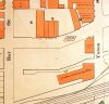
View attachment 77775
Interesting that underneath the neoclassical cladding, the Dominion Public Building has a poured concrete structure, which would have been relatively unusual for the era, given that most buildings at the time were steel-frame. The structure somewhat foreshadows Commerce Court South (1972), which I believe was steel-frame and clad in stone to create a monolithic façade.
Attachments
Goldie
Senior Member
Thanks to all, I now have my bearings.
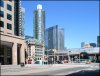
Who will be the first to give us a "Now" view from Yonge-Esplanade, looking N/W?
Who will be the first to give us a "Now" view from Yonge-Esplanade, looking N/W?
thecharioteer
Senior Member
Wouldn't it have been nice if the sensibility had been there to preserve the old Custom House (1876-1919) on the corner of Yonge and Front (survivor of the Fire of 1904) and build the Dominion Public Building beside it?


Attachments
Armour
Senior Member
That would have been quite the intersection with the Bank of Montreal, Board of Trade Building and this.
FrankRoberts
New Member
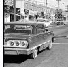
JT., do we know for sure if the original photos are from 1965 or could they be 1961?Yes, J T. The two "Then" photos appear to have been shot only moments apart.
The car on the left and the woman & cop are in both images.
Interesting that the TD is now BMO and the Commerce is gone.