|
|
|


You are using an out of date browser. It may not display this or other websites correctly.
You should upgrade or use an alternative browser.
You should upgrade or use an alternative browser.
Miscellany Toronto Photographs: Then and Now
- Thread starter Mustapha
- Start date
Goldie
Senior Member
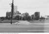
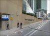
Another view of Simcoe St. - at the very end, where it meets Station St., looking N/W 1972

Now the site of the InterContinental Toronto Centre

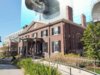
Google street view:
https://www.google.com/maps/search/...ata=!3m4!1e1!3m2!1sGgGR4aPPep8711ok2RxJkw!2e0
Now the site of the InterContinental Toronto Centre
Google street view:
https://www.google.com/maps/search/...ata=!3m4!1e1!3m2!1sGgGR4aPPep8711ok2RxJkw!2e0
Attachments

Goldie
Senior Member
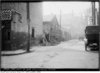
Don Mills Rd. at Wynford Dr. before widening, 1960s


Google street view:
https://www.google.com/maps/search/...ata=!3m4!1e1!3m2!1s2__CmVQlZtorxsFW-WC0RQ!2e0
Google street view:
https://www.google.com/maps/search/...ata=!3m4!1e1!3m2!1s2__CmVQlZtorxsFW-WC0RQ!2e0
Attachments
Last edited:
Ex-Montreal Girl
Active Member
Hah. Just came home from an expedition to Scarborough. Covered a lot of bases up there. Came home via Don Mills. Right now, what with all the construction, it looks like the "before" picture.
Koolgreen
Active Member
it is quite the mess....but when that cross town is finished eglinton will be a nightmare to navigate....
W. K. Lis
Superstar
it is quite the mess....but when that cross town is finished eglinton will be a nightmare to navigate....
Not for transit users, bicyclists, or pedestrians. For those who continue to use the 2-tons of metal to transport only 1.3 people per vehicle, then yes.
Mustapha
Senior Member
Inspired by the Spacing article, link below, I went for a walk today in the St. James park/Front and Jarvis area. Then came home and matched my pics with some Toronto Archives pics.
http://spacing.ca/toronto/2017/10/16/modest-proposal-archeology-park-downtown-toronto/


So that you may go for a virtual 'walk': below is a map of the neighbourhood of St James park and the now disappeared Commercial Lane and Francis Street that used to run within what is now the present park.
The Weigh House... is also on the map - curbside, near the northeast corner of Front and Jarvis.

http://spacing.ca/toronto/2017/10/16/modest-proposal-archeology-park-downtown-toronto/
So that you may go for a virtual 'walk': below is a map of the neighbourhood of St James park and the now disappeared Commercial Lane and Francis Street that used to run within what is now the present park.
The Weigh House... is also on the map - curbside, near the northeast corner of Front and Jarvis.
Attachments
-
 s0372_ss0058_it0766.jpg175.8 KB · Views: 622
 -
 IMG_4639.JPG430.8 KB · Views: 608
 -
 Jarvis St view east along Commercial St May 17 1975.jpg183.2 KB · Views: 512
 -
 IMG_4640.JPG430.8 KB · Views: 602
 -
 Corner of Jarvis and Commercial St looking east 1972.jpg148.6 KB · Views: 476
 -
 IMG_4642.JPG396.4 KB · Views: 615
 -
 s1465_fl0119_id0104.jpg177 KB · Views: 577
 -
 IMG_4643.JPG391.5 KB · Views: 610
 -
 st-james.jpg254.4 KB · Views: 883


Last edited:
Mustapha
Senior Member
Anna
Active Member
The Weigh House... is also on the map - curbside, near the northeast corner of Front and Jarvis.
View attachment 124461
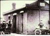
I was on the Archives Flickr page yesterday, where they have this photo of the weigh house ca 1955

Mustapha
Senior Member
I was on the Archives Flickr page yesterday, where they have this photo of the weigh house ca 1955
Thanks Anna, yours is a much better 'Then'.
")
And, that Flickr album is something I didn't know about. Some bizarre picture choices, but still pretty cool.
DSC
Superstar
Member Bio
- Joined
- Jan 13, 2008
- Messages
- 18,632
- Reaction score
- 25,389
- Location
- St Lawrence Market Area

Mustapha
Senior Member
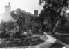
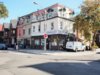
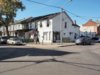
I went for a walk in Grange Park and up and down nearby Huron Street today. I wound up in my favourite dive of a bakery - the one on the south side of Dundas just to the east of Huron. The owner lady there is so pleasant.


.JPG")
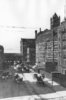
Grange and Huron, SE corner.
My maternal grandmother ran a rooming house at #35 [out of view to the left] for 40 years [50s thru the 80s].
The Mandarin Grocery was originally owned in the 50s and 60s by either a Jewish, Portuguese or Italian couple [to my young eyes]. The cold pop was in a cooler that had about a foot of water in the bottom and a upwards opening door.
Neilsons ice cream came in paper wrapped tubes that had to be 'peeled' - then the cylindrical treat was pushed carefully down into the cone.
In the 60s, woman of my moms generation would gossip outside at night in matching pajama sets and a kind of vinyl slipper which I haven't seen anymore, not even at Pacific Mall. The garment factories on Spadina employed many of them.
This is still Chinatown of course. Many of that generation remain. Most have gone, either passed, or on into homes in North York in the 70s when prosperity permitted, or later into Scarborough and then Markham. Many living here now speak Mandarin. I would also have expected to hear Viet but no luck.

.JPG")
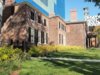
Grange and Huron, NW corner.


Grange and Huron, SE corner.
My maternal grandmother ran a rooming house at #35 [out of view to the left] for 40 years [50s thru the 80s].
The Mandarin Grocery was originally owned in the 50s and 60s by either a Jewish, Portuguese or Italian couple [to my young eyes]. The cold pop was in a cooler that had about a foot of water in the bottom and a upwards opening door.
Neilsons ice cream came in paper wrapped tubes that had to be 'peeled' - then the cylindrical treat was pushed carefully down into the cone.
In the 60s, woman of my moms generation would gossip outside at night in matching pajama sets and a kind of vinyl slipper which I haven't seen anymore, not even at Pacific Mall. The garment factories on Spadina employed many of them.
This is still Chinatown of course. Many of that generation remain. Most have gone, either passed, or on into homes in North York in the 70s when prosperity permitted, or later into Scarborough and then Markham. Many living here now speak Mandarin. I would also have expected to hear Viet but no luck.
Grange and Huron, NW corner.
Attachments
-
 f1568_it0005.jpg180.6 KB · Views: 588
 -
 PA200057.JPG335.6 KB · Views: 599
 -
 f1568_it0004.jpg218.6 KB · Views: 574
 -
 PA200061 (2).JPG387.1 KB · Views: 573
 -
 s0841_fl0048_it0010.jpg177.6 KB · Views: 611
 -
 PA200065 (2).JPG309 KB · Views: 585
 -
 s0841_fl0048_it0012.jpg166.3 KB · Views: 614
 -
 PA200063.JPG278.3 KB · Views: 582


Last edited:
Koolgreen
Active Member
Our neighbourhood Fent's variety store had that same type cooler which housed wishing well soda pops!!! How crude but functional!!
Goldie
Senior Member
Inspired by the Spacing article, link below, I went for a walk today in the St. James park/Front and Jarvis area. Then came home and matched my pics with some Toronto Archives pics.
http://spacing.ca/toronto/2017/10/16/modest-proposal-archeology-park-downtown-toronto/
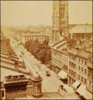
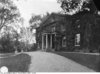
St. James' Park 1972
Looking W on King St. before clearance for St. James' Park