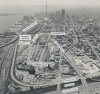
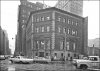
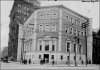
News   Apr 25, 2024
 296     0 
News   Apr 25, 2024
 932     3 
News   Apr 25, 2024
 966     0 

Miscellany Toronto Photographs: Then and Now

West Don Lands, 1988, before all the buildings were cleared:
tspa_0108960f.jpg

(via TPL archives)

Here's my attempt to reproduce the same view today on Google Maps:
west_don_lands_today.jpg
 

Attachments

  • tspa_0108960f.jpg
    tspa_0108960f.jpg
    1 MB · Views: 619
  • west_don_lands_today.jpg
    west_don_lands_today.jpg
    912.2 KB · Views: 603
It's interesting to see the industrial built form of the West Don Lands before the redevelopment projects. The old aerial shot has an additional layer of history in the label, "Proposed Ataratiri Community". It was the first redevelopment plan for the West Don Lands and was comprised of a mix of subsidized and market housing. The city and province spent $350 million acquiring the land and on the initial stages of the project before pulling the plug on it because it needed another $1 billion to actually put up the buildings.

The housing market crashed, and they realized they weren't going to get the private investment which was needed to make the project happen. As a result, the land was underutilized until the mid 2000s, when work started on the West Don Lands ahead of the Pan Am Games.

Someone once quipped after the initial redevelopment plan's failure that Ataratiri was an ancient First Nations word for "money pit". People were cynical about the merits of the project after $350 million was spent with seemingly nothing to show for it at the time. But it might be a great neighbourhood one day when fully built up. Moreover, it adds value to other neighbourhoods in the downtown area, which would have less investment potential if surrounded by industrial wasteland. Simply put, it increases the economic potential of the downtown core and makes it a better place.
 
Last edited:
Bay-Queen S/W corner -- 1965
TN Queen-Bay TD Bank 1965 TPL.jpg


TN Queen-Bay 2017.jpg
 

Attachments

  • TN Queen-Bay TD Bank 1965 TPL.jpg
    TN Queen-Bay TD Bank 1965 TPL.jpg
    442.1 KB · Views: 491
  • TN Queen-Bay 2017.jpg
    TN Queen-Bay 2017.jpg
    568.6 KB · Views: 503
Last edited:
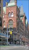
What are the "wings" sticking out each end of the building?

Very observant of you Rusty, and a good question.
Could they be walls of previous neighbouring buildings?
Perhaps someone else is more knowledgable than I.
 
Here's an earlier photo (dated 1920), Rusty,
However, your interesting question remains.

The Dominion Bank 1920 TPL.jpg
 

Attachments

  • The Dominion Bank 1920 TPL.jpg
    The Dominion Bank 1920 TPL.jpg
    391 KB · Views: 502
Other than to delineate the Bank from it's neighbours, the only other reason that I would suggest, is that of fire protection.

Regards,
J T
 
Other than to delineate the Bank from it's neighbours, the only other reason that I would suggest, is that of fire protection.

Excellent observations, J.T.
Yes, fire protection would certainly be on the minds of downtown property owners because of the devastating fire of 1904.
 
Confederation Life Building, Yonge-Richmond, c.1892

TN Confederation Life Bldg. c.1892.jpg


TN Confederation Life 2017.jpg
 

Attachments

  • TN Confederation Life Bldg. c.1892.jpg
    TN Confederation Life Bldg. c.1892.jpg
    531.8 KB · Views: 623
  • TN Confederation Life 2017.jpg
    TN Confederation Life 2017.jpg
    766.8 KB · Views: 627
Great photos. @Goldie.

Personally, what I find most interesting in the first one is not the Confederation Life building, but the construction of Robert Simpson's big new store across the street. It eventually burned down in 1895, just a few months after opening. It was rebuilt shortly thereafter, and as we all know the replacement is still there.

ETA: And people complain today about developers occupying sidewalks and lanes. Look at those bricks in 1892!!!
 

Back
Top