|
|
|


You are using an out of date browser. It may not display this or other websites correctly.
You should upgrade or use an alternative browser.
You should upgrade or use an alternative browser.
Miscellany Toronto Photographs: Then and Now
- Thread starter Mustapha
- Start date

J T CUNNINGHAM
Senior Member
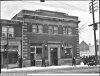
"The Dominion Bank at Danforth and Logan was photographed in 1930 because it had just been robbed."
Prof Goldie.
OK Goldie, you caught me leaving The HIT with my LOOT!
(What now?)
MIGHT'S TORONTO CITY DIRECTORY 1931:
(Danforth Avenue.)
476 Stancer Pearl, Milliner.
478 Long & Hill Real Estate.
...... Lorgheed Edgar C, Sign Writer.
480 Dominion Bank.
Regards,
J T
Prof Goldie.
OK Goldie, you caught me leaving The HIT with my LOOT!
(What now?)
MIGHT'S TORONTO CITY DIRECTORY 1931:
(Danforth Avenue.)
476 Stancer Pearl, Milliner.
478 Long & Hill Real Estate.
...... Lorgheed Edgar C, Sign Writer.
480 Dominion Bank.
Regards,
J T
nostalgic
Active Member
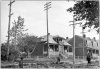
Isn’t it odd that there’s a brick second floor on the building (furrier) next to the bank in 1930, yet it’s gone in the modern view and we can see an ?older? ?bay and gable? house behind? The ground floor is the same now as in 1930 (built onto the front of the house). The brick second floor must have been built onto the front as well, but there’s no evidence of that now. I googled my way around to the lane behind to see the back of the house which has many add-ons.
Koolgreen
Active Member
I suspect the 1930 building was torn down and a new house was built and then at some point the house had an addition up front to use for the store front...
regardless, it's strange that a house was built on Danforth in that era.....
regardless, it's strange that a house was built on Danforth in that era.....
nostalgic
Active Member
It is strange that a house would be built there during the ‘30s, in an out-dated Victorian style, instead of a store with apartment above (like all the others along Danforth by then).
Goldie
Senior Member
It is strange that a house would be built there during the ‘30s, in an out-dated Victorian style, instead of a store with apartment above (like all the others along Danforth by then).
I'd suggest that those "out-dated Victorian style" homes (behind the present-day markets) were built long before 1930 --- probably when building lots along Danforth were first introduced -c.1912?
And when the street became a viable business district, those home-owners added store fronts to their street frontage.
Those stores were probably altered and changed proprietors many times until today.
Certainly interesting that the old homes still remain.
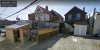
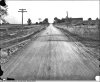
Here's an example of some homes on Danforth that could have added stores to the property.
Caption indicates "350 Danforth, 1912"
Attachments
Last edited:
Koolgreen
Active Member
If only we had a satellite view!!!
adma
Superstar
Isn’t it odd that there’s a brick second floor on the building (furrier) next to the bank in 1930, yet it’s gone in the modern view and we can see an ?older? ?bay and gable? house behind? The ground floor is the same now as in 1930 (built onto the front of the house).
Actually, you'll notice that the ground floor *isn't* the same. The 1930 version abuts the bank; the present day version is separated by a grey-plywooded gap.
My suspicion is, the original front block vanished, perhaps due to fire (but sparing the original house behind), and was replaced by the present utilitarian single-floor cinderblock (as seen from the side) add-on.
Interesting to compare the original houses behind; the wood-sided one on the left looks more authentically Victorian-vernacular (one of the Danforth's oldest survivors?), while the one on the right seems to be transitioning into the Edwardian with its dark brick front, bay window and shingled inset front gable--only the vergeboard and (remarkably intact) finial linger as c19 vestiges...
J T CUNNINGHAM
Senior Member
There is, aside from MIGHT's, GOAD's, then again, are either to be totally trusted; no.
Regards,
J T
Regards,
J T
nostalgic
Active Member
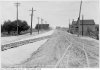
The 1912 photo Goldie posted is a gem. I suppose development along Danforth grew apace once the tracks were laid. Here’s a photo from 1913, looking east from Pape. North of Danforth still seems to be farmers’ fields; the 1915 annexation map shows streets laid out.
http://maps.library.utoronto.ca/datapub/digital/NG/historicTOmaps/1915-AnnexationDates.jpg
Here’s a google view from the alley behind those houses near Logan. I think it’s interesting to find old houses buried behind shops. There are some on the east side of Bayview, opposite Hillsdale. I see from the satellite view that there’s an alley behind the stores… I must drive along there to see what those houses look like from the back. Toronto is such an interesting city!
Attachments
r937
Active Member
i know Goldie will like this... several "then and now" pics of the Winchester St bridge, and the Belleville Subway, where Winchester Street went under the CP's Belleville Subdivision, a.k.a. Don Branch, as part of a longer thread on the Lower Don Trail... you should be able to just scroll down and see all the pics
https://twitter.com/rudydotca/status/891703810212626432
https://twitter.com/rudydotca/status/891703810212626432
Goldie
Senior Member

Goldie
Senior Member
Goldie
Senior Member
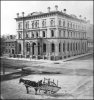
Bank of Toronto, N/W corner Church-Wellington, 1868


Google street-view:
https://www.google.com/maps/search/...ata=!3m4!1e1!3m2!1sV3AZCZH_UMK4zbsYDeuccw!2e0
Google street-view:
https://www.google.com/maps/search/...ata=!3m4!1e1!3m2!1sV3AZCZH_UMK4zbsYDeuccw!2e0
Attachments
junctionist
Senior Member
That was a tragic loss for the city's built form.