


adma
Superstar
Don't forget Wabash when it comes to such past roads-with-rail-alongside...
|
|
|
The tracks are poking out through the asphalt in your photo were deceptive in terms of recreating the location; perhaps a similar building was located on Princess. Nonetheless, the 1927 is interesting for other reasons. If the tracks in the 1927 photo are train tracks, it would be a rare instance of heavy rail street running in Toronto. I've only found evidence for it happening on Basin and Sudbury Streets in Toronto. Yet note the overhead wires across the street. They might have been streetcar tracks. If they were streetcar tracks, it's possible that freight was being moved with the streetcar network, something I wouldn't mind seeing today. Alternately, the warehouse produced goods for servicing the streetcar network. It's a curiosity.
Street cars,These were streetcar tracks The building at the SE corner of Front and Frederick (now the Theatre for Young People) used to be a TTC (or Toronto Street Railway) building and still belongs to the City. It was used as a powerhouse and I think the TTC owned other buildings further south on Frederick. The TTC also owned the site on north side of Front Street (where Greyhouind now is); this siqe was recently sold and a 34 (really) floor building is proposed. There are quite a few "then" photos (including this one) of this area on a condo building site (www.mtcc573.ca)
First post here..
According to an Upper Canada Railway Society 1971 walking tour handout, the building in the photo was originally the Toronto Railway Company Motor Shops bulding (first section built in 1892), for repair of streetcar motors and the Stores Dept. It gradually expanded and was replaced by the new Hillcrest Shops in 1924 by the TTC. It was then used for storage, and in 1927 was re-opened as a Freight and Express Terminal for for the Toronto & York Metropolitan Division (the Lake Simcoe line), on which the TTC did have some light freight traffic. In 1930 it was turned into a bus garage, which it remained as until it closed in 1980 (then known as the Sherbourne Garage). It was used for TTC buses until 1966, and then by Gray Coach Lines until 1980 when Gray Coach moved to Commissioners St (now the Wheel-Trans garage). It was demolished not long after that.
July 20 Then and Now.
Then. "Sep 23, 1927. Frederick St. and west entrance to Freight Sheds."
Someone went to some expense to convert a warehouse into a train accessible building. Note the freshly modified doorway. I wonder what kind of business went on here?
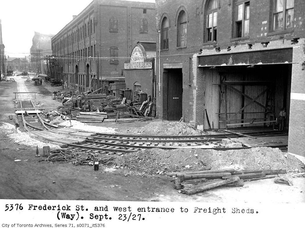
I think we have not quite got it yet. We are looking at the west side of the The Theatre for Young people Building (on south side of Front Street). It is Designated and is described in the listing as:
Toronto Street Railway Stables, 1887-88, H.G. Salisbury, (now known as the Young People's Theatre) -adopted by City Council on June 20, 1973 DESIGNATION BY-LAW PASSED BY CITY COUNCIL on March 17, 1976. That is the more elegant building, the Freight Sheds were apparently to the south of it and may have extended over to Sherbourne Street.
I think that there was a Sherbourne Street Freight Building on north side of Front Street (where the Greyhound now is) - there is a photo of it at https://gencat4.eloquent-systems.com/webcat/systems/toronto.arch/resource/ser71/s0071_it5375.jpg I am not clear whether the photo is south or north of Front Street, if south it looks as though the track went in at the east side of the building on Frederick - as seen in the original photo - and came out on the west side at Lower Sherbourne - as shown on this link. Maybe someone with access to a 1920s map can confirm?


Wish I could open that Goad's map, can't seem to find a plug in for Firefox yet.
It just seems that the iron foundry in the first then shot separates the YPT building from the Frieght building.
And yes, the YPT building does appear to have been shortened.
"it would be a rare instance of heavy rail street running in Toronto." QUOTE junctionist.
Liberty Street, Mowat Ave, Pardee Avenue, Jefferson Ave, Hanna Avenue - lower crossing, Liberty St East, Eighth? Street - New Toronto,
just to name a few "rail roads".
"it's possible that freight was being moved with the streetcar network,' QUOTE junctionist.
Differing guage; not possible.
Regards,
J T
I think that there was a Sherbourne Street Freight Building on north side of Front Street (where the Greyhound now is) QUOTE]
The UCRS handout notes that the north-west corner of Front & Sherbourne where Greyhound is located was a small car yard, with a carpenter's shop to the west on the north side of Front and a "storage/battery building" at the north-east corner of Front & Frederick.
A small remnant of track is actually visible on Frederick today - a curve coming out of the Gray Coach/Greyhound Bus Parcel Express terminal.
Regards,