News   Jul 16, 2024
 112     0 
News   Jul 15, 2024
 866     3 
News   Jul 15, 2024
 988     1 

Transit Fantasy Maps

If you look at the DRL study the TTC released last year it stated that no new yard would be needed for the DRL if it was build just st. Andrew to Pape. 4 storage tracks if the the East and West portions were built, and 7 storage tracks if the East line and the extension to Eglinton was built. The only time it would need an actual new yard would be if all 3 parts were constructed. This could easily be achievable under the powerlines in Flemingdon park.

Hmm interesting. I had always heard that a site in the Portlands was under consideration for the yard.

as for the stop, are you thinking something along these lines?

unionsplitstop_zpsca34328b.jpg


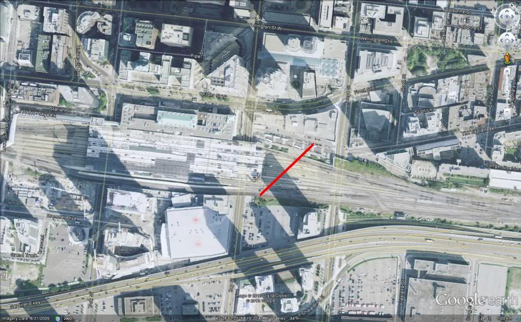
If so I find it quite counter-intuitive. The subway at the corner of Front and Yonge is very shallow. (the whole 1954 yonge line is) you would only really have about 150 meters to drop the needed 10-11 meters to build the station. That is about a 7% grade, something that subways simply can't handle. Not to mention the fact that it would be cutting right through the the foundation of the historic dominion public building. Then there is the fact that you would be building the stop underneath of 14 active rail tracks, instead of a closable king street.

DRL_De-Coupling.jpg


This is more what I had in mind. You can see that the station box avoids the foundation of the Dominion building (although admittedly just barely). Based on the grades as well, I have the Yonge line passing overtop of the Spadina-Don Mills line. That may pose a problem coming east from the existing Union Station though. I admit that this would need a more detailed feasibility study than what I have the resources or the expertise to do, haha.

The new Union station would need to be a shallower station, that much is true. And as for digging under active rail lines, is that not exactly what they're doing now only a couple hundred metres away? If the new Union platform needs to be a Dundas-style station with the concourse underneath, then admittedly that's less than ideal, but it could still work, and would still be less expensive than a massive new station in the heart of the CBD.

In order to build the wye, Front from Bay to Church would need to be closed, as well as Yonge from the Esplanade to Wellington. This can potentially be mitigated by temporarily making Wellington a two-way street between Bay and Church.

And I don't really think King St is that closable, especially in the long term. Unlike Front (which is currently and will be closed for at least the next year), King has a busy streetcar route, and multiple parking garage access points on it. That is why if the separate line option is chosen, I very much favour Wellington.
 

Attachments

  • DRL_De-Coupling.jpg
    DRL_De-Coupling.jpg
    96 KB · Views: 721
The spots I would propose building the Stations on King would be from yonge to around bay and from University to the western edge of Roy Thompson Hall. No parking garage access points there, and while two lanes do interesect king at these points, they have access from other streets. as for the streetcar, the King streetcar would likely have to be replaced with a bus service anyways as there would be large disruption along the entire line regardless of what plan is used.
 
The spots I would propose building the Stations on King would be from yonge to around bay and from University to the western edge of Roy Thompson Hall. No parking garage access points there, and while two lanes do interesect king at these points, they have access from other streets. as for the streetcar, the King streetcar would likely have to be replaced with a bus service anyways as there would be large disruption along the entire line regardless of what plan is used.

Yup I would agree with that, although I'd still shift it 1 block south to Wellington, specifically to avoid the streetcar disruptions you mention. Come to think of it, if a Wellington-Front-rail corridor-Pape alignment is chosen, I don't think that would impact the King streetcar at all, except for maybe a few localized delays.
 
Hmm interesting. I had always heard that a site in the Portlands was under consideration for the yard.


View attachment 10258

This is more what I had in mind. You can see that the station box avoids the foundation of the Dominion building (although admittedly just barely). Based on the grades as well, I have the Yonge line passing overtop of the Spadina-Don Mills line. That may pose a problem coming east from the existing Union Station though. I admit that this would need a more detailed feasibility study than what I have the resources or the expertise to do, haha.

The new Union station would need to be a shallower station, that much is true. And as for digging under active rail lines, is that not exactly what they're doing now only a couple hundred metres away? If the new Union platform needs to be a Dundas-style station with the concourse underneath, then admittedly that's less than ideal, but it could still work, and would still be less expensive than a massive new station in the heart of the CBD.

In order to build the wye, Front from Bay to Church would need to be closed, as well as Yonge from the Esplanade to Wellington. This can potentially be mitigated by temporarily making Wellington a two-way street between Bay and Church.

And I don't really think King St is that closable, especially in the long term. Unlike Front (which is currently and will be closed for at least the next year), King has a busy streetcar route, and multiple parking garage access points on it. That is why if the separate line option is chosen, I very much favour Wellington.

Interesting to see it that way. Thanks.
 
let's not kid ourselves. Nobody will get off at Bayview/Gerrard and then take the DRL to the core, instead of arriving at Union directly with the ability to walking in the PATH to their office.

The point I was trying to make with my fantasy map, rather than any specific DRL alignment, was that you shouldn't have to 'transfer' between the DRL and most GO lines.

Assuming we rejigged to the regional network a bit to have two main portals, one around DM/Eglinton and one in the Junction, most regional trains could just run through the DRL. Proposed station spacing between downtown and DM/Eg is usually just over 1km, which is quite common station spacing on the urban portions of Tokyo commuter lines. The Western leg is a bit more ambiguous since there's less consensus on alignment but spacing realistically wont be much lower than 800m-1km. Maybe it would take 15mins to get from Dundas West to downtown (6km @ 24kph), but GO only does it in 14m as it is, so it's not like running commuter trains through a western DRL would be intolerably slower.

This would kill soo many birds with one (admittedly expensive) stone. Track space in the rail corridor currently used by GO could be used for the DRL. Money saved from not having to tunnel through downtown could be redirected towards the infrastructure necessary to run a modern EMU based commuter rail network (15m all day, bidirectional service). Our commuter rail network would finally have access to destinations beyond Union station and better integration with existing RT systems. There would be no need for cockamamie schemes like a secondary Union Station at Bathurst or a new GO tunnel to increase train movements.
 
Interesting thread.

1st point. Dundas East Mississuga - Someone was asking who would take a subway all the way along Dundas into Toronto? When I first moved to Canada, I didn't have money to take GO Transit and hope I had enough cash for it. I knew exactly how much local transit cost without accessing the internet to find out. I sat and waited on Dundas MT to the Subway and then all the way in TO. Just because it was slow, not everyone has money to take express services. I'm shocked you even have to ask this question.

2nd point. Transit misses Peel so much when so many of us are Immigrants around the Airport. Seems like too many regular Canadians wouldn't dream of taking transit, while the immigrant population don't mind taking transit at all. Meanwhile, good luck trying to get from South Brampton to South Etobicoke within a reasonable amount of time. You have to back track multiple times, long stretches. Or trying to get from Brampton to Milton. Or even the Airport. The schedule two years ago was two hours by transit vs a fifteen minute drive. That's not reasonable. There is a lack of integration for transit from Brampton into South Mississauga and Etobicoke. Express heading torward TO assumes you want to go downtown.

Metrolinx doesn't really give a crap about Brampton. Throw in the LRT and problem solved? It might be easy to get around Brampton using Brampton Transit. The hard part is connecting with other cities. Isn't that what Metrolinx is supposed to be all about? Connecting Metro areas? Brampton hasn't nearly finished growing. It might appear to be low density, but most of the houses, unlike Mississauga, has multiple families per single family home. The houses are built closer together than I see in most of Toronto. And there areas like Bramalea and DT Brampton that have tall apartment buildings and condo's and townhouses. Brampton is higher density than is appears on paper because the North and West hasn't been built up yet. It doesn't need Subways, but BRT's on Queen and Hurontario connecting it with other cities have been a huge success. Add the Airport and Etobicoke and old TO and I'm sure those would be a success to. Right now, those working around the airport drive because the buses aren't helpful. But come 5pm, Airport Rd from Derry to Carlingview is at a dead stop. This whole area is a transportation disaster and all of these GTA transit plans completely ignore these issues. The Airport is being choked to death if you ask me. So much time and money being wasted.

BTW, Brampton is the youngest community in the GTA by median age with a high birth rate. GTA Transportation plans ignoring Brampton is just so incredibly dumb. It seems whenever they increase service, they fill up straight away. If I take the GO bus when the train isn't running during the day, I have to make sure I get on the earlier stop or I probably won't get a seat. I see empty buses in Mississauga and Vaughn. Meanwhile, the buses here are very busy. Focus should go to the people who actually want them to use them.
 
Last edited:
The next wave of the big move includes all day 2 way electrified GO rail, a 10km Queen street BRT (that will allow through routing to York regions highway 7 brt) and of course the Hurontario LRT. Quite a bit for a city that currently had essentially nothing in transit infrastructure.
 
The next wave of the big move includes all day 2 way electrified GO rail, a 10km Queen street BRT (that will allow through routing to York regions highway 7 brt) and of course the Hurontario LRT. Quite a bit for a city that currently had essentially nothing in transit infrastructure.

The all day GO line has been a carrot waved in Brampton many times. I'll believe that when they tell us how it will be funded. At this point, I don't even care about paying the taxes for it, it's past due. "Quite a bit" doesn't mean much when it's overdue and you've been looking at transit routes to go places and realized the time is quadrupled or worse compared to just taking a damn car.
 
2nd point. Transit misses Peel so much when so many of us are Immigrants around the Airport. Seems like too many regular Canadians wouldn't dream of taking transit, while the immigrant population don't mind taking transit at all. Meanwhile, good luck trying to get from South Brampton to South Etobicoke within a reasonable amount of time. You have to back track multiple times, long stretches. Or trying to get from Brampton to Milton. Or even the Airport. The schedule two years ago was two hours by transit vs a fifteen minute drive. That's not reasonable. There is a lack of integration for transit from Brampton into South Mississauga and Etobicoke. Express heading torward TO assumes you want to go downtown.
There's a whole chunk of routes that Brampton Transit is trying to fix internally. After the next set of Zum routes, which are Bovaird from Mt. Pleasant to Airport Road in 2014 (serving basically most of the new suburbs), Steeles West to Lisgar GO in 2015, and Queen West in 2016, there are a bunch of other routes that are up for Zum consideration. That includes Airport Road as a very stronger contender (probably as an extension of Bovaird).

Meanwhile, Brampton is trying to increase the frequencies of each the primary arterial transit routes (think of the major arterial roads) to very high frequencies before anything becomes a consideration for a Zum BRT-lite route. I know there's a possibility for a new Mi-Express route on Dixie (which frankly, absolutely needs it) from Mid-Brampton to South Mississauga.

Etobicoke is an entirely different problem. It involves some co-operation between the 905 and the 416. Also, the Big move entails that moving between nodes and cities needs to completing happen, but it's not if each hub is going to be its own spoke-hub system. Form Brampton to Milton, you're going to transfer at least once.

The Dixie route is one I just don't bother using. Take a car or taxi or anything but transit. One bus to Shoppers world, transfer, another bus east, transfer, Dixie south, transfer, dixie south, transfer, another bus. Reach destination. Miss three or four connections along the way and you have long waits in between transfers. Realizing you just spent the bulk of your day on the bus for a twenty or thirty minute drive? Priceless.

It's the same BS for Kennedy, halfway into Mississauga, you have to transfer. You have to be pretty desperate before you'll agree to take these routes or really close to the lines to start with. Are they sure they're watching which way people are going? There are routes like the 53 that are so long and winding, you can walk to your 4km destination with a child faster than taking the bus.

I hope they fix it. But when I looked at the Big Move map, like other regional plans, it looks like the Brampton map is just dumb. http://samepageteam.files.wordpress.com/2012/07/region-map.png
If transit is to be a reasonable alternative to cars, it needs to consider where people are going by car. And when you're paying Brampton insurance rates, people get as much use out of their car as possible, because paying for transit while paying for a car is really expensive. The discounts only come when you use transit every day and not just for commuting. If you can't easily get everywhere by bus, people won't pay for a bit of both, people choose the one that will get them everywhere easily that costs a little bit more.
 
So you want a unified Peel Transit system, no?

I, along with many others, are really hesitant on this. The reason we're hesitant is that a merger might mean that Mississauga, as they have done in the past with other things, might strong arm and shaft Brampton's transit services. They're the bigger party in this and they might decide, with more transit vehicles at their disposal, they might decide to shift the balance between the two.

The functions of routes like the 53/54/35/other windy routes is that suburbs in those areas aren't fully formed and and the roads aren't complete. They're mostly there to provide immediate transit service. Something like the 54 James Potter will almost certainly be straightened out and run the route once the full section of it is built from at least Steeles to Williams Parkway.

The windy routes are community collectors. They serve their purposes, and some of the are segments or relic of Brampton Transit routes that have existed forever. Like the 8's almost non-sensical routing is because that route is one of the oldest in the system.

Dixie is possibly one of the busiest non-Zum routes in the city. You might not use it, but I frequently do, either three days of the week to get to the terminal to get to school, or the other two days where I take it to the employment areas just north of the 407. It's combined rush hour frequency is at 7.5 minutes, and even still, sometimes I get passed. And Dixe heads about 1/3 of the way into Mississauga too. I'm sure the Kennedy is the same situation, though it only hits Derry.

The Brampton Big Move Map only includes the dedicated RT routes. It misses Queen West, Bovaird, and Airport and Mississauga Road, which are BRT lite, and the existing 115 Airport Express on Bramalea.

Increasing the frequencies of our trunk routes will decrease transfer times. It is possibly my biggest misgiving and concern about the Big Move, something I brought up at a Metrolinx Roundtable Discussion: we build all these RT routes, but what is the guarantee that all the feeder bus routes will also increase (I was, by the way, late for said meeting because of the elusive missed transfer on a Saturday).

Brampton Transit WILL be having Public Consultation Meetings this spring. Go to one, or email the people. Get on their case to increase frequencies. I'll be sure to post when they are available. But also post suggestions of routings, etc.
 
I don't make it out to the meetings. I stay home with the kids and send husband. I don't think he really thinks to ask the questions I would, mostly because he doesn't travel with the kids as much as I do.

I would use Dixie and Kennedy if they didn't take so long to get to, require, transferring to MT halfway and then more transfers. It's the sheer number of transfers to keep children occupied while on the side of the road that gets to me.

"Get off the ground and stand up."
"Don't lick the window."
"Don't kick rocks, you'll hit cars and people."
"The bus will be here soon."
"Don't stand near the curb, you're making the drivers nervous."
"Don't touch that, it's dirty."
"Careful, they've got a lit cigarette."

Too many transfers is a lot to deal with bringing kids, to the point that you quit using those routes even if you have to give up whatever it is you wanted to do. Thirty minutes to an adult is like asking a kid to wait three hours.

Some of the winding routes aren't so bad. The 8 case in point runs both ways and actually intersects with useful routes. It's just so infrequent outside of rush hour that I have to walk. I try to avoid buses during rush hour because of the stroller, but then that means, 40+ minute waits between buses and needing to be back in time for half day kindergarten and school buses. I can't risk being late of the school bus or the take the kid back to the school and then I have to figure out how to get to the school and back. With such infrequency, the chance of missing a transfer is too great to take the bus.

It feels as though transit plans revolve around one adult getting around.
 
That's because about 95% of riders are over the age of 10 and can manage fairly well independently. If transit were built to ferry around kids, 95% of riders would be inconvenienced so 5% of riders can get around a little bit more comfortably.
 
I transfer with kids all the time. Not sure the big deal. Two 10-minute trips with a kid is often easier than one 20-minute trip as it breaks up the journey, and gets them on their feet.

I certainly don't see what kids have to do with the discussion about transfers any more than anyone else. And I'm really not sure why this is being discussed here in a fantasy map thread.

How about some nice maps showing the Yonge line going to Iqaluit?
 

Back
Top