News   Jan 08, 2025
 751     0 
News   Jan 08, 2025
 1.2K     1 
News   Jan 08, 2025
 563     1 

Transit Fantasy Maps

Aren't there utilities, etc in the way of your proposed pedestrian connection between Union and ... Union East?

I know it's an unrelated project. However I had suggested extending the Lower Bay Concourse under Bay st to connect with the Bay East Teamway as a way of eliminating some of the jay walking that happens on Bay. I recall the buried utilities posed a barrier to this suggestion.

It wouldn't be a Union East, rather a single interchange station with a longer than normal pedestrian connection. Less than Spadina, more than others. And that's just a vague placement of the connection. Optimally it could be more direct.

And yea gain storage, gain another line, improve Union capacity, provide direct service to the waterfront...
 
Line 1 does not even need to be continuous through Union. How many people make that U-turn journey? Even if some people make it, it won't be a loss to them because they will only need to walk about 600 meters extra.

That should also help with managing delays as problems on Yonge line won't affect University line and vice versa.

Also, we can boast having our 5th subway line without doing much work :cool: (just like how UK "added" lanes on its highways by converting shoulder lanes into traffic lanes)
Wouldn't it be more logical for Yonge branch to reach Union? Maybe the University branch could be extended.

On the other hand @Reecemartin posted a video last week suggesting we just skip the expensive improvements to the Union streetcar loop in anticipation that other network improvements may render that unnecessary. It seems reasonable to me. Not delaying necessary transit service to huge new developments by decades because we can't prioritize the Cadillac solution has some merit.

 
Wouldn't it be more logical for Yonge branch to reach Union? Maybe the University branch could be extended.
I don't think that matters. In 44 North's proposal, the new Union East subway station is pretty much as close to the Union train station as the current Union subway station. In fact, Union East is closer to the bus terminal.

From the perspective of passengers not bound for Union train station, Union East may be slightly closer to the centre of Financial District (Bay and King) than the current Union station.

Extending it south on Yonge will make ferry terminal more accessible, making Centre Island one step closer to the green spaces starved downtown.
 
This is an idea I've presented before. It was on my mind again, and this is a bit more detailed. It's in response to the mammoth cost and time to expand Union Loop for a waterfront LRT. A project that singlehandedly has delayed any new streetcar service to the waterfront. Rebuilding said loop requires a lengthy shutdown of current streetcar service, and when all is said and done and we're $500M out of pocket, the result is no net increase in transit kms.

So what if instead we brought the subway to the waterfront LRT (by way of a severed and extended Yonge line)? Poke holes if you want. But I see merit in it.

View attachment 454378

The water table may be a concern; not sure how significant.

The subway station will be longer than the existing Ferry Docks streetcar station, and probably placed deeper too.
 
Wouldn't it be more logical for Yonge branch to reach Union? Maybe the University branch could be extended.

On the other hand @Reecemartin posted a video last week suggesting we just skip the expensive improvements to the Union streetcar loop in anticipation that other network improvements may render that unnecessary. It seems reasonable to me. Not delaying necessary transit service to huge new developments by decades because we can't prioritize the Cadillac solution has some merit.


Yes, that may be a low-cost solution, even if a temporary one.

Isn't it possible to retain the existing underground loop for the QQ West line, and feed the QQ East streetcars into the core using surface routing? Looping via Yonge, King, Lower Jarvis, back to QQ East? Or via York, King, Yonge?
 
I feel like people underestimate how many people take the subway through union. Every time im there im surprised by the amount of people who stay on the train.
I recall someone posting recently that the point at which it is still advantageous to ride the U rather than walk is about Dundas to St. Patrick. To be generous you could trim that to Dundas-Osgoode or Queen-Osgoode.

The union “U” is valuable, and any southern extensions should still pass through it imo. Make a QQ station an eastward extension of a split Spadina Line instead of need be. I think it is this principle which makes the TTC want to just use the Streetcars instead, as splitting Line 1 is a net negative at Union either way and forces a transfer on QQ where there doesn’t need to be one.
 
I just did the first of a series of fantasy maps for Toronto based on Open Street Map (done via Paint 3D). In the map for southern Etobicoke, I extended Line 2 west of Kipling along the Galt Subdivision under the 427 before swinging it around Sherway Gardens to parallel Brown's Line down to Long Branch GO, then parallel the Oakville Subdivision ROW to Port Credit and linking up with the new Hurontario LRT.

Also tossed in two LRT lines managed by Peel Region, one using the OBRY/Galt Sub tracks from Brampton directly to Kipling, the other being an LRT version of the Dundas BRT also linking to Kipling.

 
This is an idea I've presented before. It was on my mind again, and this is a bit more detailed. It's in response to the mammoth cost and time to expand Union Loop for a waterfront LRT. A project that singlehandedly has delayed any new streetcar service to the waterfront. Rebuilding said loop requires a lengthy shutdown of current streetcar service, and when all is said and done and we're $500M out of pocket, the result is no net increase in transit kms.

So what if instead we brought the subway to the waterfront LRT (by way of a severed and extended Yonge line)? Poke holes if you want. But I see merit in it.
I had proposed something similar way back when, but my proposal had the station box angled on a SW-NE angle, going right through what is now CIBC Square (but was an empty parking lot at the time). This would have enabled a westward extension of the Yonge Line under Lake Shore to a new station in the Lake Shore & Lower Simcoe area. I also had an eastward extension of the University Line from the current Union platform under Front St as the DRL. Clearly a different era in transit planning to be sure :).
 
This is an idea I've presented before. It was on my mind again, and this is a bit more detailed. It's in response to the mammoth cost and time to expand Union Loop for a waterfront LRT. A project that singlehandedly has delayed any new streetcar service to the waterfront. Rebuilding said loop requires a lengthy shutdown of current streetcar service, and when all is said and done and we're $500M out of pocket, the result is no net increase in transit kms.

So what if instead we brought the subway to the waterfront LRT (by way of a severed and extended Yonge line)? Poke holes if you want. But I see merit in it.

View attachment 454378

I was instantly reminded of this when I saw your post.

20150324-MC-Map.jpeg
 
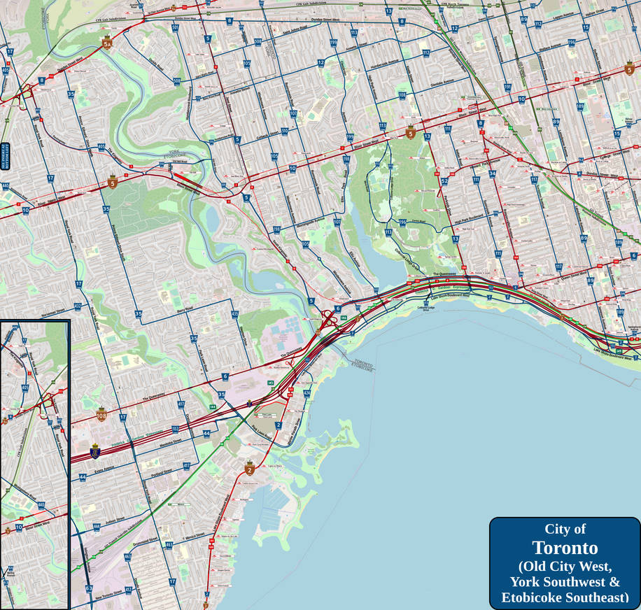
Second fantasy map now done, showing western Toronto, southeast Etobicoke and southern end of York. Here, I show a few things...

1) I extend the Ontario Line (heretofore called Line 3) west along the Oakville Sub from Exhibition, that following along the Lakeshore West and VIA Corridor/Maple Leaf service to around the south end of High Park before arcing same northwest in a general direction towards Old Mill Station on Line 2, eventually pressing on past the interchange between Dundas West and Islinton before it goes off map (and whose end part will be shown in an upcoming map of central Etobicoke).

2) I extend Line 512 west along Saint Clair onto Dundas via Scarlett to eventually have same end at a new loop near Kipling GO/TTC station. Such will link to a new streetcar line along Kipling north from there to Line 6; I give this route the number Line 513.

3) I put in the Jane LRT service as Line 8, it being on the surface mostly before going underground near Jane station on Line 2, then heading south to link up to Line 3 in Swansea. Since both lines are planned for standard gauge track, they can share the lines from Swansea east to Exhibition where Line 8 will end.

Enjoy!

 
And here comes the fantasy map of central Etobicoke now, showing what I have in mind for not the Line 5 western extension, but also extending both Lines 3 and 6 to Pearson Airport, adding in a LRT version of the Mississauga Transitway and a streetcar line covering Kipling Avenue.

Enjoy!


Back
Top