News   Jul 15, 2024
 407     2 
News   Jul 15, 2024
 563     0 
News   Jul 15, 2024
 566     0 

Transit Fantasy Maps

Updated my map to show a new thing I added: A Lake Shore East LRT in Phase 2, with a Portlands LRT and then a Queen LRT in Phase 3. Phase 3 is obviously the very long-term projects, but I think it's worth putting it in there. Because none of the 'Queen System' connects to Bloor-Danforth at all, I think LRT is the appropriate technology choice. It's a more of a secondary line.

https://dl.dropbox.com/u/43869799/MoveToronto_v6.jpg
 
I don't know how I feel about a Lake Shore East LRT. There seems to be little development potential and connectivity with the 100-300m buffer along either side of the route. Although this section of Lake Shore on your map has a very large roadway allowance to allow for it, I do not see the viability.

I do believe that in the future - when we see real development in the Port Lands - some kind of E/W route will be needed. But I think this should be an branch of the Cherry Street streetcar line, perhaps along Commissioners (where a key part of waterfront redevelopment will be).
 
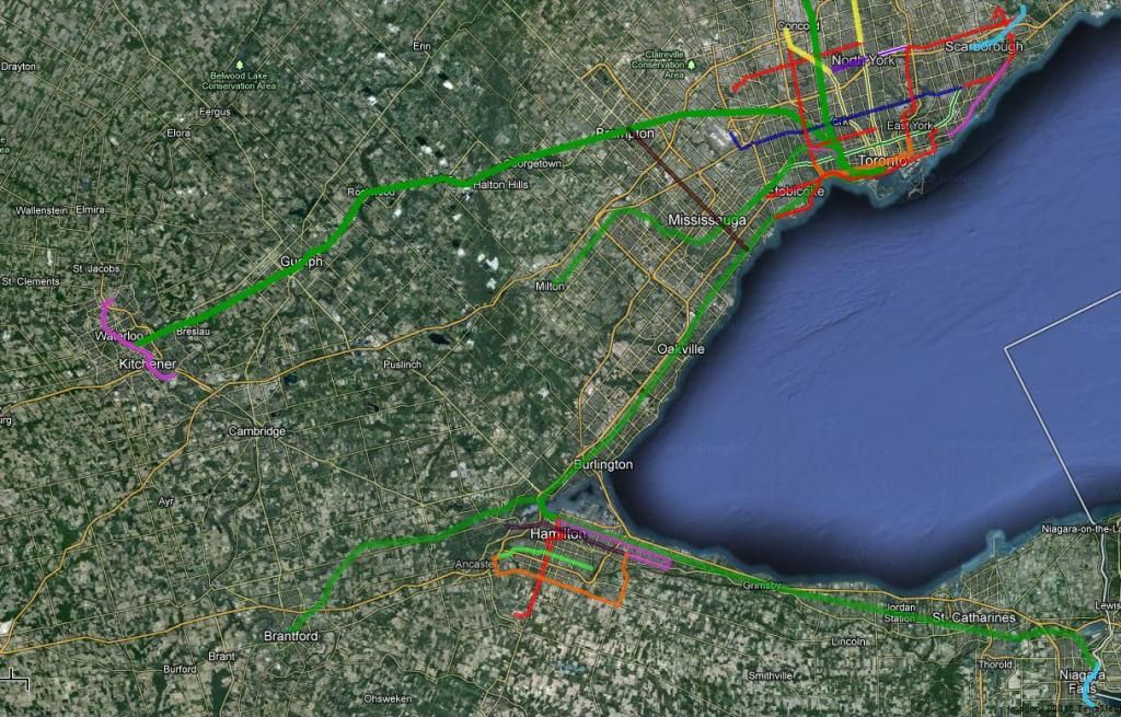
Something of a fantasy map.
hhwpkkH.jpg

There are five major components to this.

1.) Yonge Extension: I went kind of over the top and imagined it extending all the way to Elgin Mills. A more realistic/practical goal would probably be the current YSE proposal. But an extension from a terminus at Hwy 7 could be accomplished cheaply using the nearby rail corridor and spacing stations way out.

2.) DRL: I've opted for a typical rail corridor DRL, though extended further into Agincourt & the Junction. In order to save costs, this DRL would poach rail corridor space from GO and in Union Station. If more money became available I'd rather have a Queen alignment, but I think this would be more economic. The only substantial difference would be my route skipping Flemingdon and cutting across to Eglinton/DonMills. This should lower construction costs and better facilitate regional trips, while Flemingdon would apparently have been quite low ridership anyways.

3.) Regional Branches: The only really novel part of my fantasy would be having GO/REX feeder routes branching off of my DRL. This isn't even that novel, actually. I know drum118 has suggested running the Richmond Hill line into the DRL and it's pretty common in Japan for commuter rail services to run through subways. This should kill two birds with one stone. It would be easy to transfer tracks currently used for GO to be used by the DRL and it would bring regional rail service to most of the 416/905. The exact service levels would depend. Assuming the central DRL trunk was built to accomodate 30-36 tph, during peak the western branches could see 10-12 tph each and the eastern branches 15-18. Those frequencies could allow even further branching (e.g. 4/10 Brampton trains serving Pearson, or a spur to the Buttonville development). To keep costs low and travel times high, station spacing would be on the order of every 3-4km.

4.) Reconfiguring GO: Transferring the busiest parts of GO to this new network would raise questions for the remainder of the GO Train network and regional rail in general. The fringes of Lakeshore West, Lakeshore East, Georgetown & Milton Lines wouldn't be served by this new network, nor would Barrie or Richmond Hill. These routes could be configured into a more proper regional or intercity rail or bus network. Some routes, like Richmond Hill, would probably just be converted to bus. Others though may, in future, become part of a Southern Ontario 'slow' HSR network using high speed DMUs, something like the Chicago Hub.

5.) Local Transit: My fantasy map didn't contain any kind of LRT or BRT system. I felt those systems weren't really relevant to illustrating the regional rail network I imagined, so I ignored things like the Finch West LRT or Scarborough LRT or Hurontario LRT. If a network like this ever got built, I'd expect most stations to connect with at least one high-volume surface route (either LRT, BRT or some kind of 'BRT lite'). I'd imagine that surface route investment would yield way higher cost benefit ratios than my rail network, so don't read their absence in my proposal as some kind of subways uber alles thing.

I'm not sure what the total cost of this network would be. It would require some tunneling (e.g. in East York), but proportionately little. Mostly surface running and infrequent station spacing should keep total station costs down. The cost of the regional branches would be related to what extent they reuse existing GO infrastructure. In total I'd guess between 15-20 billion? That's obviously a lot, but considering the Eglinton-Dundas West DRL would probably cost about 10b and REXifying some GO lines would probably cost a few billions it should be roughly cost neutral with current proposals.

I'd argue my concept is better because Toronto could avoid having to build an expensive tunnel across downtown, while our regional rail network would gain better access to micro destinations other than Union, increasing its usability.
 
I don't know how I feel about a Lake Shore East LRT. There seems to be little development potential and connectivity with the 100-300m buffer along either side of the route. Although this section of Lake Shore on your map has a very large roadway allowance to allow for it, I do not see the viability.

I do believe that in the future - when we see real development in the Port Lands - some kind of E/W route will be needed. But I think this should be an branch of the Cherry Street streetcar line, perhaps along Commissioners (where a key part of waterfront redevelopment will be).

My main rationale behind it was to connect to the beaches neighbourhood around Kingston & Queen. That way it would intercept (or possibly even interline with) the Queen streetcar, providing a significantly faster route downtown. And for most of the Lake Shore route east of the DVP, it's only a couple hundred metres from Queen St, at most. Add to that the fact that they're already building a carhouse right along the route too.
 
A couple hundred metres at most? More like just under 0.5km at its closest point, 800 to 900 metres elsewhere.

The LRT would have the added benefit of providing a faster route downtown - moreso to the southernmost point of downtown. But IMO the potential DRL stop at Queen could achieve this. On top of that, 501 ridership coming from east of Woodbine is static. Current ridership is on the lower end, and there will be no major projects to increase the low density in this area of the city.

IMO any kind of quasi-rapid transit in this particular area of the city should be on Commissioners and as part of the waterfront redevelopment. But we'll probably have teleportation by then :)
 
A couple hundred metres at most? More like just under 0.5km at its closest point, 800 to 900 metres elsewhere.

Still walkable. I've done the walk in reverse quite a few times (on Lake Shore walking up to Queen to catch the streetcar). It's a pretty painless walk IMO.

The LRT would have the added benefit of providing a faster route downtown - moreso to the southernmost point of downtown. But IMO the potential DRL stop at Queen could achieve this. On top of that, 501 ridership coming from east of Woodbine is static. Current ridership is on the lower end, and there will be no major projects to increase the low density in this area of the city.

IMO any kind of quasi-rapid transit in this particular area of the city should be on Commissioners and as part of the waterfront redevelopment. But we'll probably have teleportation by then :)

The route that I had had it ending at a West Donlands DRL/GO REX station in the medium term, and eventually connected to a Queen LRT in the long term. And I don't think Queen East is going to be as static as you think. Yes the Beaches may only see limited development, but west of Woodbine I think we're going to see quite a lot, especially with the industrial areas south of Queen/around Lake Shore.

The problem that I have with a Commissioners LRT, at least right now, is that without the redevelopment along that corridor, it's borderline useless. At least by using Lake Shore and bringing it out to the Beaches you have a line that is both useful in the short term, and can serve as a catalyst for development in the medium and long terms. And realistically, Lake Shore and Commissioners are only ~300m apart. Any line along Lake Shore is also serving that area, when/if it develops. But a line along Commissioners will be of very little use to anyone along the Queen corridor.

That's just my view though :p.
 
My main rationale behind it was to connect to the beaches neighbourhood around Kingston & Queen. That way it would intercept (or possibly even interline with) the Queen streetcar, providing a significantly faster route downtown.

It could interline with the Kingston Road car too. Could be an opportunity to actually make the Kingston line somewhat useful.
 
It could interline with the Kingston Road car too. Could be an opportunity to actually make the Kingston line somewhat useful.

Very true. I'd just like to see Phase 1 end around Kingston & Queen, and depending on how ridership patterns change, evaluate potential extension options (eastward along Queen, northeastward along Kingston, northward along Woodbine) from there. It could even eventually replace or meet up with the Kingston Road BRT (yes, I realize that it ends well north of Queen, but an LRT extension could bridge the gap at least).
 
So here is the 1st version of my fantasy map for the next 20 years or so. Yup, it's a pretty massive map, and a pretty big PDF, so it may take a while to load, depending on your connection.

The table in the top left corner shows what each line numbering (A1) represents. The various extensions are labelled as well. The legend shows what each type of line means. The dashed lines for local transit mean BRT Light, while the white line down the middle denotes a grade-separated line.

There should only be a couple "what the hell is that?" things on here, because most of it is derived from current plans. There are a few curveballs though, but finding them may be like playing Where's Waldo...

Any comments or questions, feel free!

https://dl.dropbox.com/u/43869799/GTA System Map - To Scale.pdf
 
Western Greater Golden Horseshoe Area Transit Network

GGHA_Transit_zps806028fd.jpg

by me


Toronto TransitCity *for some reason googlemaps' SRT got cut out
Hamilton RapidTransit
K-W LRT
Niagara Falls PeopleMover LRT
Peel (Hurontario) LRT

GO Hamilton
GO Niagara
GO Barrie
GO Milton
GO Kitchener
GO Brantford-Hamilton (via JamesNorth GO)
 
Realistic fantasy perhaps?

Yes, it is intended to be a semi-realistic map. Most of the things included on this map are currently in the Big Move, although the technology may have been changed. There are only a few routes that have been significantly altered or exist on here where they don't in the Big Move.

I have a Phase 3 layer in the Ortelius map file, but I didn't include it in this export because it makes the map look really crowded. It includes things like a Crosstown GO, Sheppard West extension to York U, and a Queen LRT that connects the Lake Shore West and East LRTs.
 

Back
Top