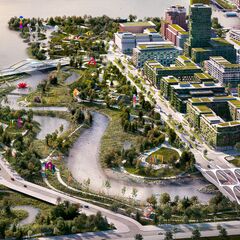
Toronto Lower Don Lands Redevelopment | ?m | ?s | Waterfront Toronto

I at one time wondered if the colour scheme related somehow to the various colours of cherries, but I can't recall any evidence for that.
 
A story on the seedbank discovered as part of this project over at City News:


Not much new info; but a good quick read on the subject.........

Odd quirk I hadn't heard about, they also recovered an intact, never opened jar of pickles in the digging.......

No indication if anyone has since opened the jar! LOL
 
A throwback comparison of the Cherry St. North bridges site. September 2020 and July 2022. Both photos taken from my kayak in the Keating Channel. Note the progress of Block 8 - West Don Lands in the background under the west bridge (currently on temporary mounts).

IMG_20220714_120025.jpg
 
Last edited:

Traffic Notice

Overnight Lane Shifts on Lake Shore Boulevard East between Saulter Street and Logan Avenue: July 25-October 2022

To facilitate utility connections under the reconstructed Lake Shore Boulevard East, there will be nightly lane shifts at four intersections along Lake Shore Boulevard. Lanes will be shifted on both Lake Shore Boulevard and the intersecting streets from Monday, July 25 until the end of October. Work will focus on one intersection at a time, for approximately 5-10 days each. During this work, lane shifts will only be in effect from 10:00 p.m. to 6:00 a.m. Work will take place at the following intersections, starting at Saulter Street, and heading east:
  • Saulter Street and Lake Shore Boulevard East
  • Bouchette Street and Lake Shore Boulevard East
  • Booth Avenue and Lake Shore Boulevard East
  • Logan Avenue and Lake Shore Boulevard East
b47d6b79-4a97-4b90-1968-70115b491de1.png
Above: A map showing the areas with lane shifts on Lake Shore Boulevard East and side streets.

WHAT TO EXPECT​

  • Lane closures along Lake Shore Boulevard East, between Saulter Street and Logan Avenue. At least one lane of traffic will be maintained in each direction on Lake Shore.
  • Lane closures will be marked with traffic barrels
  • Traffic will be directed into the remaining open lanes
  • Road plates will be present in the work area during the day
  • Lane restrictions on the north-south streets connecting to Lake Shore Boulevard
    • Saulter Street, south of Lake Shore Boulevard
    • Bouchette Street, south of Lake Shore Boulevard
    • Booth Avenue, north of Lake Shore Boulevard
    • Logan Avenue, both north and south of Lake Shore
    • Two-way traffic will be maintained on all side streets
5cc5eaf8-f8ec-4efc-a941-52270eac33c7.png

Upcoming Work

Cherry Street between Commissioners Street and Polson Street: Late August 2022

Crews will be working over one weekend in late August to connect the new Cherry Street alignment to existing Polson Street. This work may require the closure of the northbound lanes on existing Cherry Street between Polson Street and Commissioners Street for one weekend. More information about detour routes and road closures will be available in our next notice.

The new alignment of Cherry Street between Polson and Commissioners Streets will be opening in late August. Once open, existing Cherry Street will be closed from Commissioners Street to Polson Street so we can continue excavating the new river valley.
5cc5eaf8-f8ec-4efc-a941-52270eac33c7.png

Construction Update

cd3cec80-643c-ac2d-a9ae-7b375d6f48cf.png
Above: A map showing the upcoming work in various areas of the Port Lands. To open a larger version of this map, visit the Port Lands Flood Protection Construction Schedule Webpage
Canoe Cove Excavation
8066126d-5e94-c877-d337-55aadb867b57.jpg
Above: Excavation of ‘Canoe Cove’ on the north side of Polson Slip is complete. Crews are now creating small islands in the cove. Once complete, it will be part of Promontory Park South and feature a place to launch small watercraft with little islands to paddle around.
Cherry Street North Bridge Arrival
cac65b69-9841-c3a1-ad6b-8abf34cd88e5.jpg
Above: The cycling, pedestrian and vehicular bridge for the Cherry Street North crossing arrived in early July. Like the other bridges, it travelled along the St. Lawrence Seaway before being moved into its location. In this photo you can see it floating in the Keating Channel, perpendicular to the transit bridge that arrived in 2020.
Pedestrian Bridge Installation
0dd833d9-f691-bcd0-999d-c04027087bce.jpg
Above: The pedestrian bridges were pre-fabricated and arrived on a truck. Then they were lifted into place by a crane.
f70395f4-05aa-a5c8-028c-d3b3115951d1.jpg
Above: Two pedestrian bridges were installed in June. This one spans the wetland in River Park South.
2ce7d522-f6dc-52f2-ab03-0275058f4d52.jpg
Above: The second of the two pedestrian bridges crosses what will be the main river channel, to connect the parks on either bank.
Plantings
a96238bd-ec48-da8f-288e-def827e9fec5.jpg
Above: We’ve started planting wetland plants on the north side of the main river channel. The large logs on the right will also be part of the wetland, and provide variety to the habitat.
438c19fa-7ef8-9405-d375-c1698dbbe1ab.jpg
Above: Plants have started to grow out of the Fibre-Encapsulated Lifts. These lifts line the river channel and some areas of the wetlands to build up the banks. The fibre provides stability to the soil and prevents erosion until the roots of the plants become established.
Ice Management Area
fbfa4953-49b6-8b60-9000-75d258a6d927.jpg
Above: Excavation is complete under the Commissioners Street Bridge. Now we’re installing a river liner in the ice management area to prevent any contaminants in the soil from seeping up into the new river.
Lake Shore Bridge
793c16b5-3716-f896-4a92-b201e0d2f63e.jpg
Above: The south half of the Lake Shore Bridge over the Don River has been removed. Crews are now excavating on the west side of the bridge to make the river wider in this location and install new piers for the lengthened bridge.
 

This is a large, almost essay-style piece giving people a synopsis of the history of the area, Hurricaine Hazel (not the former mayor, LOL) ; as well as a sense of how the whole project came together.

It's a very laudatory piece.

From said article:

1659034532483.png


1659034698931.png


* note here, 'Sweeney' is Herb Sweeney, a Principle at MVVA

***

1659034587001.png
 

172. Cherry Beach–Route update effective August 8​


Effective August 8, 2022


Routing adjustment – road network change

172 Cherry Beach
will be re-routed in the Port Lands, as the first portion of new Cherry Street is opened to traffic.

Buses will operate on the new alignment of Cherry Street (between Commissioners Street and Polson Street).

Map of route diversion
 
I'm surprised that road will be open that early but the curbs are now in place for the southern approach to the south cherry bridge.

Took this today while biking past (no tags).

PXL_20220728_200915312.jpg
 

Back
Top