Developer: Metrolinx, Infrastructure Ontario
  
Address: Eglinton Ave W & Emmett Ave, Toronto
Category: Transit
Status: ConstructionCrane(s): N/A
Height: ? ft / ? mStoreys: ? storeys
Project Forum 3.4K posts
Real Estate Forum
Follow 8 followingUpload 227 photos
Official WebsiteReport Error


Toronto Eglinton Line 5 Crosstown West Extension | ?m | ?s | Metrolinx

I wonder what kooky names they’ll come up with for these stations.
Robert Bruce Ford Memorial Station
Doug Ford Senior Memorial Station
Royal Mattamy Station
Deco Logos and Tags Station
Richview Station
Nashville Developments Martin Grove Station
Renforth Pearson International Airport Gateway Station
 
Last edited:
Jane -Eglinton Flats/Humber Flats
Scarlett - Scarlett
Royal York - Edenbrook
Islington - Richview
Kipling - Widdicombe Hill
Martin Grove - Willowridge
Renforth - Renforth Gateway

Richview Gardens, please.... so we demarcate the district and not the collegiate.

Jane/Eglinton might deserve to be called Carrying Place or even Teiaiagon (a bit of a geographical stretch, perhaps, but the indigenous settlement in the area and the indigenous attachment to the river merits recognition ).

I wonder how long before John Scarlett's connection to slavery leads to debate.... just think, we have a Premier who graduated from a high school named after a slave owner.

- Paul.
 
Last edited:
The more they do it, the more I dislike the stations named after neighbourhoods instead of streets. For a traditional GO line, it makes sense to name the stations after the town or village, but for an LRT? Give me a break. An LRT should not have it's station names named confusingly.
 
This probably wouldn't be appropriate as Richview is the name of the entire neighbourhood between Royal York and the 427 and is centered around Richview Park, which is closer to Martin Grove.

Maybe Silver Creek would work?
I think Richview makes a lot of sense, you’re right about the size ofthe area but most people will associate the area to the high school. I grew up around Renforth and Eglinton in the early 70s and was a Boy Scout with “Richview” on our scarfs, even back then people would assume we were from the area near the high school and library.
 
New York's R train has a 23rd St in Manhattan and a 25th St in Brooklyn; its B train has two Seventh Avenue stops; and Chicago's 'L' has 5 stations named Western (with two being on the Blue line). People can figure it out. It's obvious that Islington station on the Bloor line is at Islington and Bloor, while an Islington station on the Eglinton line is at Islington and Eglinton.

The issue with using neighborhoods for wayfinding is that it's non-specific and pretty subjective. Forest Hill can mean anywhere from Marlee to Avenue (depending who you're asking). When I have to go somewhere, almost never do I think I have to go to "Fairbank" -- I have to go to Dufferin and Eglinton. The latter being far more specific about where I need to go. It doesn't matter if I'm driving, on the bus, or on foot -- if I look for Dufferin, I know I'm on the right track. "Fairbank" only helps if I happen to know the area already, whereas Dufferin I'm going to encounter just by naturally going through the city.

At its worst, this results in things like things like Pioneer Village being 1km from it namesake, and the future Flemingdon Park station being closer to the Science Centre than its namesake (if the Science Centre doesn't move altogether)

There's also two Kennedy and Steeles intersections in the GTA and nobody seems to be very bothered about it.
 
Last edited:
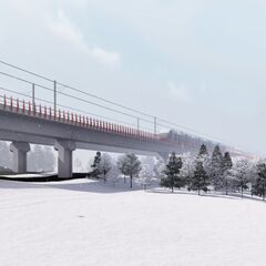
Station renderings from the new release:
- Jane
- Scarlett
- Royal York
- Islington
- Kipling
- Martin Grove
- Renforth

View attachment 550985

View attachment 550986

View attachment 550987

View attachment 550988
My worry about the elevated sections is that the underpasses become ugly blights similar to the Gardiner underpasses downtown. Was hoping they'd be creative and incorporate different materials into their design like is done in places abroad(like Netherlands, for example).
 
So we should have Islington (Bloor), Islington North (Eglinton), Islington Very North (Finch LRT) , and Islington Very Very North (when Q7BRT gets upgraded to trains)?
Or, you know, Islington - Bloor, Islington - Eglinton, Islington - Finch, etc. Why jump to such extreme hyperbole?

Why is the road itself the important part of the destination anyways? I swear, car-brain rot gets people in the weirdest ways sometimes.....
Fascinating logic. Since when do only car owners need clear and precise instructions as to where they're going?

Neighbourhoods can be very large, or the chosen name for the area might be obscure (like Cedarvale), or there might even be multiple stations in a neighbourhood, like most stations on the Bloor-Danforth line. There is no world in which neighbourhood names are clearer and provide more wayfinding value than street names.
 
Even if you just left the name as "Islington" for line 2 and "Islington" for line 5, I think people are smart enough to figure out which one it is.

Every bus route refers to the stops by the street name, not the neighbourhood, and people are not confused by this, it's logical and intuitive.

Naming the stops after neighbourhoods that no one has ever heard of doesn't make it car-centric, I cannot even imagine where that logic comes from.
 
The way they’ve named stations on the Eglinton line after neighbourhoods is dumb too. An example: Chaplin is in the middle of Forrest Hill, but the Forest Hill stop is actually right at the edge of the boundary with the adjacent Cedarvale.

I think I’m certain cases, neighbourhood names could make sense. I don’t think Metrolinx has figured out when that’s the case, though.
 

Back
Top