Toronto Spadina Subway Extension Emergency Exits | ?m | 1s | TTC | IBI Group

Does anyone know the status of the Wilson Yard expansion? I seem to recall that it was intended to open in September 2018, but I have not heard anything about it. Has the TTC started using the new connecting track to Sheppard West?
 
Partial ridership numbers are in. It's a great day for Bessarion, as it is no longer the least used station in the network!

Finch West: 17,000
Downsview Park: 2000
Highway 407: 2,900

Source: line-1-subway-update-1.4861277

CBC also claims:
According to figures provided to CBC Toronto by the TTC, 57,100 riders boarded trains at the new stations during a week of service in May, though the TTC notes that the York University strike may have lowered those numbers.
Which would be 8,157 riders across six stations per day, which makes no sense at all. Someone made a typo here
 
I imagine that York being closed is a huge influence on the line's ridership. York is likely the busiest station on the line when the school is open.

I'm interested to know the ridership of VMC station. I see it being relatively low now, but having extremely strong growth rates over the next few years as the rapid development growth occurs around it.
 
Partial ridership numbers are in. It's a great day for Bessarion, as it is no longer the least used station in the network!

I consider Line 3, so Ellesmere (1,760/day) would be the one to forever hold the crown in that regard. Though it's only 500m from Midland so helps explain that.

Wonder if this is only counting boardings, but not departure. So maybe the numbers are actually double? Finch West thought would be a bit higher.
I really want to know PV's ridership, especially since so many bus routes terminate there.
 
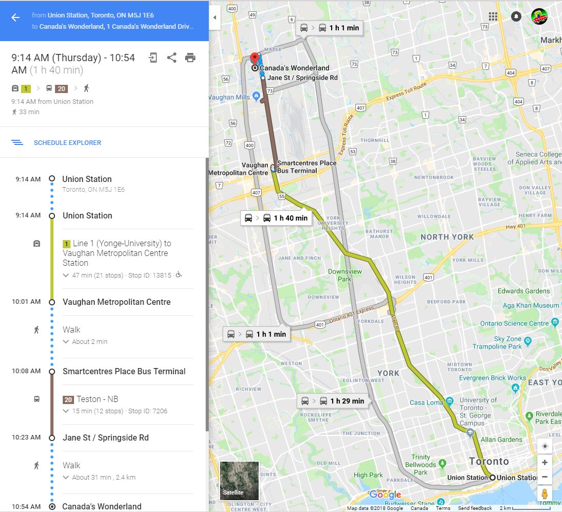
I was recently shocked by a major omission by Google Maps that falsely added 25 minutes to Canada's Wonderland journeys.

See diagrammed:

View attachment 151266

Google "Toronto Union Station to Canada's Wonderland"

Google Maps falsely claims taking the subway to Canada's Wonderland takes:
1 hour 40 min
That is incorrect, it is only 1 hour 15 min

DiltnftXcAA79RI.jpg


DiltUpUXsAAaM7y.jpg


So I reported it to Google. (You should too) (and City of Toronto should use their tool too)

Dilx84IXkAA5QJP.jpg


Countless people have been falsely discouraged about how useless the Vaughan subway is for getting to Canada's Wonderland.

But this is simply a minor omission in Canada's Wonderland that falsely inflates Google Maps trip estimates for a Canada's Wonderland public transit trip.

People do use the new subway extension for Canada's Wonderland (with the #20 bus transfer) -- it's quite a comfortable ride to Canada's Wonderland with only 1 transfer. Just 1h 10min.

Shuttle buses may be faster offpeak but the subway is significantly faster at peak, but the 25 minute penalty from the Google Map omission is.... rather shocking.

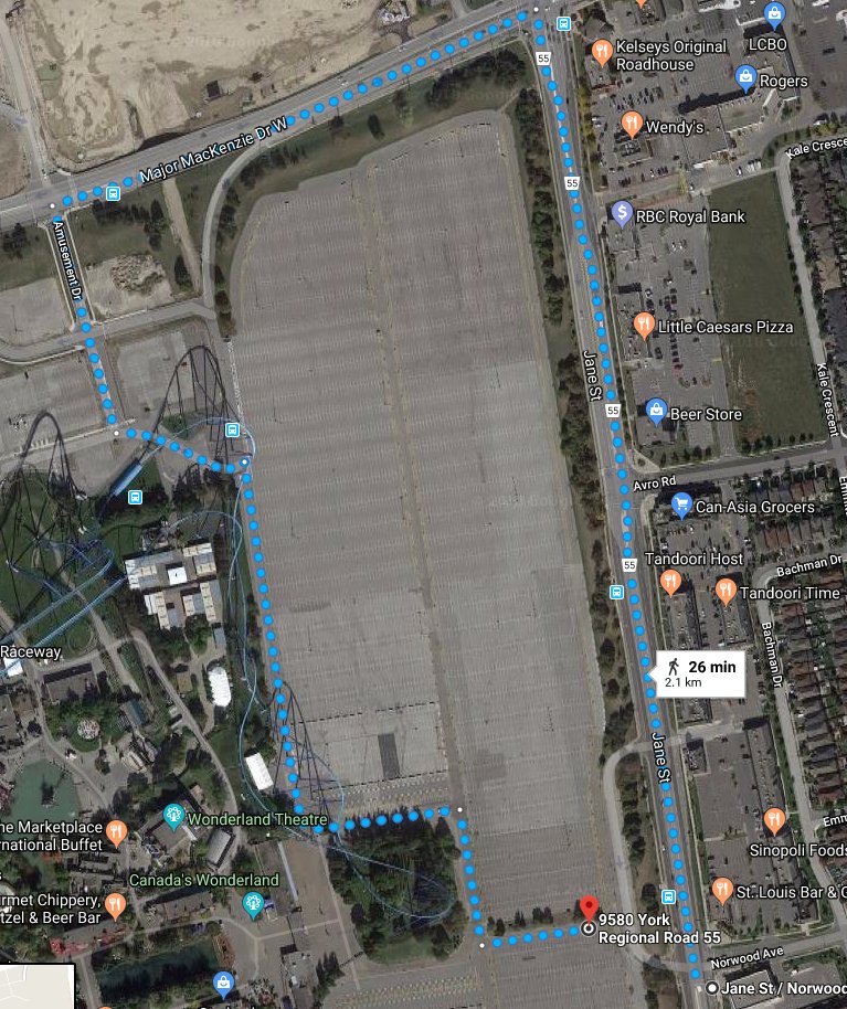
The audacity of this oversight is amplified when you see this:

View attachment 150785

....Google Maps lets you do GPS walking directions between two rides!

If this love was all spilled lovingly into updating Google Maps, then the oversight is quite -- blatantly -- ridiculous.

View attachment 151266

*Bangs head on desk*
*headdesk*
*headdesk*
*headdesk*

Surprised nobody has fixed/reported this til now.

Thousands of people googlemap "Union Station to Canadas Wonderland" and it's a falsely inflated result of 1h40min for subway trips.

Just because of *this*

Thousands of people have done these Transit Directions search already.

We spend this big $ on a subway to Vaughan, and yet this oversight ("Vaughan subway seems worthless for Canadas Wonderland" is a comment I've heard) -- still remains uncorrected to this date? A simple matter of Google Maps fixing their pedestrian routes, from user reports & city of Toronto reports.

Hopefully this get fixed quickly by Google now.

Surprised this was uncorrected to this date.

Hallelujah!

Google Maps finally fixed their colossal inconvenience screwup -- where many subway trips (via VMC) were falsely quoted as 1h40min from Union to Wonderland.

I know families who's wasted time because of this Google transit mapping flaw -- that did things like cause Wonderland goers to get off 1 bus stop too early -- or stay on the bus too long -- or navigated the entire north-south parking lot via the south edge -- with super frustrated kids in tow screaming "why didn't we take our car"..

It's now a reasonably decent 1h15min with the subway extension -- gate to gate -- from inside Union to inside Wonderland (sometimes less) with a mere 400 meter walk from bus stop to the front gate of Wonderland -- along pretty-looking trees & pretty-looking close-up walk past Leviathan roller coaster as visual eye candy appetizer -- instead of an accidental but boring sun-searing 15-minute parkinglot walk from the south or north -- for many buses that don't go all the way to the gate.

Happy kids, happy to have taken transit. Shorter walk from bus stop to Wonderland gate than the walking distance from most parking spots! Parents glad to have saved parking fees with the TTC family day pass.

It's finally now optimized to the correct Jane+Norwood bus stop -- for the #20 for the fastest and most pleasant subway+bus trip.

upload_2018-10-16_17-16-41.png


upload_2018-10-16_17-15-18.png


This fixed Google Maps will save countless lost families in 2019 -- saving huge headaches trying to Google-Transit to Canada's Wonderland.

Five more years -- of happy families taking transit -- and Canada's Wonderland can expand their Park shutting down 25% of asphalt -- taking over partially abandoned parking asphalt. It'll no longer get filled 100% in 2025+ thanks to subway extension.

The external Canada Wonderland parking lot surface is a whopping 50% of acreage of the admission-paid Canada Wonderland acrage. Even a slight parking lot shrinkage is still a windfall of massive new extra amusement-park land for Canada's Wonderland.

This Google error fix that saved 25 minutes off subway trips -- making formerly invisible transit searches visible again (due to long-trip-time cutoffs) -- may become one of the most valuable gifts from Google to Canada's Wonderland, because of this. In a decade from now, in hindsight, anyway.

____

Additional transit speed enhancement in the future: With 15-min GO RER and bikeshare (from Rutherford GO station to Wonderland), a 45 minute non-car trip is possible, too. Bike infrastructure permitting. That would actually beat the speed of a drive! Today, you can sort of do this with evening northwards Barrie trains -- if you bring your bike onboard a Barrie GO train (just barely outside peak hour disallowance of bikes). If you're lucky to be at Union right before a Barrie departure as the Barrie train takes only ~30min to Rutherford GO station, and the Rutherford GO station is only a 15 minute bike ride from Wonderland's front gates. There are two bike racks between the Leviathan posts, for those who are interested in attempting a cycle to Canada's Wonderland. This no doubt, will need to improve over the long-term in the mode-switch-driven cannibalization of asphalt parking with new rides.
 

Attachments

  • upload_2018-10-16_17-15-18.png
    upload_2018-10-16_17-15-18.png
    807.9 KB · Views: 1,649
  • upload_2018-10-16_17-16-41.png
    upload_2018-10-16_17-16-41.png
    225.4 KB · Views: 559
Last edited:
I can see a hundred years from now, the Spadina leg being extended further north in the City of Toronto (formerly the City of Vaughan, before it was annexed) with stations at Vaughan Mills and Canada's Wonderland. Vaughan Mills' parking lot being turned into condos, since petroleum fueled vehicles would be prohibited by then.
 
Last edited:
How do you propose we get Google Maps to add the yellow line on their maps for the TYSSE?

It still isn’t there. Frankly, that’s embarrassing.
Calm down there, one game changing fix at a time!

But I agree, it’s crazy that it still doesn’t show a line on the transit overlay 9 months later. Though, it doesn’t have TTC bus routes, so probably need to wait for the TTC to work with Google.
 
How many of those passengers are connecting to/from GO trains, versus elsewhere?
I imagine this will improve dramatically with 15-min GO.
God I hope so, but at the same time, if Metrolinx doesn't get their shit together and fix the cluster duck that is transferring to York University, we could continue to see this station as a boondoggle for decades to come. It also doesn't help that Caledonia and Bloor-Lansdowne are going to hopefully be built, and transferring up north will only be reserved for Barrie commuters heading to Yorkdale, or along Sheppard Avenue.

Sheppard avenue: first Bessarion, now Downsview Park. Why can't developers build more condos there? Downsview Park actually has some stuff to offer, unlike a graveyard and parking lot at HWY 407...
Speaking of fixing the fare integration and transfers for the TYSSE. I’ve noticed a significant increase of riders at Richmond Hill Centre Terminal taking the 51/52/54 towards York University. I would assume that these people used to take Viva Purple, but since it no longer goes to York U (or even Pioneer Village), the GO bus is the preferable alternative to transferring on the street or Promenade Terminal. Of course these are probably the people who can afford the extra fare, while most people have to make the unintuitive transfer.

I really hope fare integration or a proper YRT route between Richmond Hill Centre and Pioneer Village Terminals comes before GO Transit pulls service from York U to terminate at Highway 407 Bus Terminal.
 
How do you propose we get Google Maps to add the yellow line on their maps for the TYSSE?

It still isn’t there. Frankly, that’s embarrassing.
Even OpenStreetMaps is well ahead of Google Maps.

OSM even has Line 5 Eglinton since a few years ago!

Oh, and it's added by volunteers, not GIS technicians earning six-digit figures annually who often spend their day looking at graffiti using Street View (or come December, looking for a certain jolly old elf clad in red with a dozen levitating reindeer or come April, playing Pac-Man with existing streets).
 
Speaking of fixing the fare integration and transfers for the TYSSE. I’ve noticed a significant increase of riders at Richmond Hill Centre Terminal taking the 51/52/54 towards York University. I would assume that these people used to take Viva Purple, but since it no longer goes to York U (or even Pioneer Village), the GO bus is the preferable alternative to transferring on the street or Promenade Terminal. Of course these are probably the people who can afford the extra fare, while most people have to make the unintuitive transfer.

I really hope fare integration or a proper YRT route between Richmond Hill Centre and Pioneer Village Terminals comes before GO Transit pulls service from York U to terminate at Highway 407 Bus Terminal.

This is just speculation on my part, but I suspect York U administration was the force behind removal of YRT service to York U. As I mentioned earlier, a CSA I talked to at Pioneer Village said the TTC wasn't planning on forcing YRT to withdraw service without fare integration in place (despite the Binding Agreement). But (IIRC) a YRT rep on Twitter said that YRT "[doesn't] have permission to enter campus". What I predict will happen is that sometime during the 2018-19 school year (or soon after), GO will take over YRT's former space near the Archives building, thus vacating the Commons bus loop. With GO buses gone from the Commons, York U would not mind if GO stayed on campus indefinitely. But since there's less space on Ian Macdonald Bvld, and because they spent a ton of money building the Hwy 407 Terminal, GO will have its Highway 407 West buses (like the 46 and 47) terminate at Highway 407, while Highway 407 East buses (like the 51/52/54) will serve York U before terminating at Highway 407.
 
Last edited:
This is just speculation on my part, but I suspect York U administration was the force behind removal of YRT service to York U. As I mentioned earlier, a CSA I talked to at Pioneer Village said the TTC wasn't planning on forcing YRT to withdraw service without fare integration in place (despite the Binding Agreement). But (IIRC) a YRT rep on Twitter said that YRT "[doesn't] have permission to enter campus". What I predict will happen is that sometime during the 2018-19 school year (or soon after), GO will take over YRT's former space near the Archives building, thus vacating the Commons bus loop. With GO buses gone from the Commons, York U would not mind if GO stayed on campus indefinitely. But since there's less space on Ian Macdonald Bvld, and because they spent a ton of money building the Hwy 407 Terminal, GO will have its Highway 407 West buses (like the 46 and 47) terminate at Highway 407, while Highway 407 East buses (like the 51/52/54) will serve York U before terminating at Highway 407.
That’s an interesting rumour. But would the 407 East buses use Keele and 407 or use Jane to get to and from Highway 407 Station?
 

Back
Top