News   Apr 26, 2024
 1.1K     4 
News   Apr 26, 2024
 293     0 
News   Apr 26, 2024
 830     0 

Should the TTC subway map include streetcar lines?

I don't understand why people say any of the maps are too busy. God forbid Toronto gets the money to double the subway system.
 
"The "G" line on the 2nd map seems a little strange."

Every stop between Stouffville and Agincourt is reversed.
 
Besides, putting GO lines on the TTC rapid transit map would imply the same degree of service that one can expect from the subway and rt lines.
Not necessarily (as Montreal has demonstrated). I think if the GO lines are a single colour and thinner than the subway lines it naturally implies a different carrier (and even level of service).

I wouldn't be surprised if the new GTTA pushes for this to be honest.
 
This was made by somebody on SSP

Toronto_Transit_White_Med.gif
 
i really like the idea of including the streetcar lines on the subway maps, like on that first example. IMO all of these arguements about 'implied levels of service" make little sense... to me, these maps are simply a tool to help riders get from one place to another as efficiently as they can. and including the streetcars would help people who might not be as familiar with the city, to plan their route.

and i would say that to most people, adding the streetcar routes makes a lot more sense than adding the GO train routes. i know of very few people (read: none) who use the GO train to get around town, while the streetcars are used by virtually everyone.
 
Re: streetcars, let's not forget that light rail/subways/s-bahn/whatever in MANY cities run on much longer headways than our streetcars, even when those streetcars are bunched up and off schedule. What is the average time between trains on the Montreal metro? 8 minutes or so off peak, right? Some of the outer El lines in Chicago are even longer than that.

As far as speed of travel, streetcars are fundamentally different from busses in that they don't have to pull over to stop. This eliminates a lot of dead time.

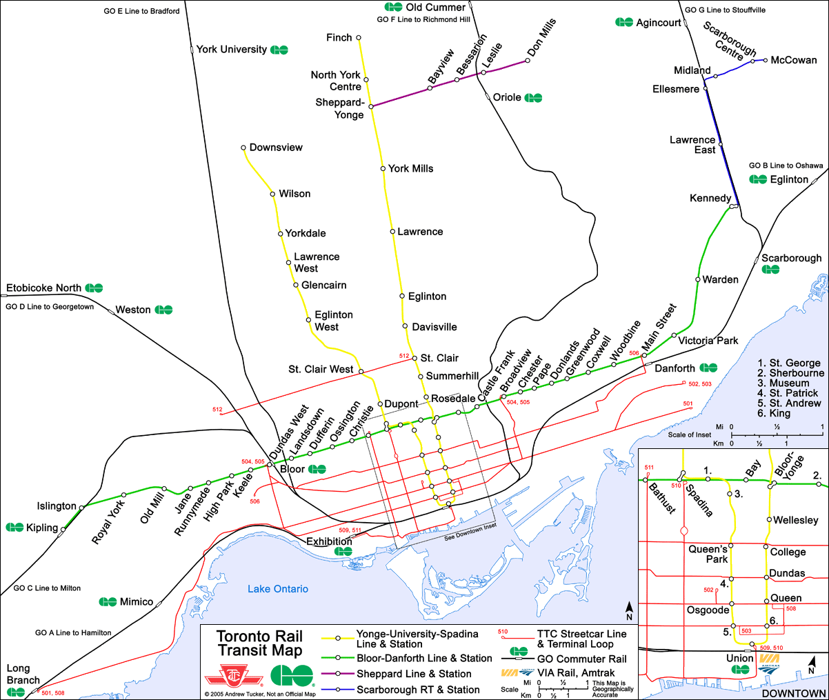
Bottom line is that I think putting streetcars on the map makes a good amount of sense. Believe it or not, one of the Fodor's Toronto guides has am amzing "downtown rail map," with subways and streetcar lines with stops! It might be the most useful Toronto transit map I've ever seen.
 
And they are called "streetcars". People should get the hint that they travel on the street and not underground. I'd include them and the GO lines. Use a disclaimer if you have to.
 
second map

I like the second map. A couple of thoughts.

1. VIVA should somehow be on there.

2. It emphasizes the GO line running from Union to York U. It also emphasizes that there's no intermediate stop for it on the Bloor line ... is there?

I guess it's been said before a billion times but, having just come back from Paris and witnessed the metro/RER integration ... man, subways and GO trains really need to get interconnection game.
 
Re: second map

^it stop at Dundas West and Kennedy on the B-D line.
 
Re: second map

^it stop at Dundas West and Kennedy on the B-D line.
It stops close to Dundas West. There's a 5 minute walk between Bloor GO and TTC Dundas West stations.
 
"1. VIVA should somehow be on there."

If so, then all TTC express bus routes should also be on the map. VIVA can be added when it grows into something with more substance (infrastructure).
 
Only rail transit should be on the map, no buses. Otherwise it would be just like the regular TTC map which is pointless.
 
Including the lake in any future subway map is also a very vital point to consider.
 
The streecar routes look fine except that they shouldn't be red - that's too prominent a colour.
They should be gray or black or blue. The most prominent lines should be the ones that give the highest level of service - subway and RT (speed/capacity/frequency).
 

Back
Top