News   Apr 25, 2024
 361     0 
News   Apr 25, 2024
 1.1K     4 
News   Apr 25, 2024
 1.1K     0 

Roads: Gardiner Expressway

I never said anything about the Don.

I said the Toronto LANDS which I assumed you knew that land doesn't include a body of water.

They could simply have the freeway exit near the DVP and build a bridge/overpass connect to it just as the elevated Gardiner would do. The developers would build most of the new highway, no need for expensive ventilation systems, maintains freeway access to downtown, and gets the Gardiner out of sight and out of mind.

It's a win all around.........the City saves a king's ransom, developers get cheaper land, the residents and entire Waterfront get rid of the noise and visual pollution of the elevated Gardiner. If Minneapolis can have an LRT go thru the functioning underground parking garage surely Toronto can have a much simpler to build road straight thru one.
 
I like the trenching idea too. The problem is that you do end up squeezed for land east of Jarvis, as you'd have to trench beside the existing Lake Shore and Gardiner. That's why complete removal of the Gardiner east of Jarvis, I believe, is the best option. I actually read most of the draft EA, and one of the alternative proposals was to have the Gardiner be at grade between Jarvis and Parliament or Cherry, basically incorporated within a wide Lake Shore Blvd. What I like about this option is it creates greater connectivity from the St. Lawrence Neighborhood north of the tracks to the East Bayfront area along Queens Quay. It also means that Cherry St. is treated like the important gateway to the Port Lands that it will be. If you read between the lines of the report, you get a very strong sense that the Villiers Island/Port Lands Precinct was planned with complete removal of the Gardiner east of Jarvis in mind (see figure 3.34). My guess is that many in the Planning Dept. are holding out hope that when Tory goes and the city's financial challenges are reconsidered, the hybrid option will get dropped in favour of removal. In any event, I hope that whatever remains elevated is given the best treatment possible. The Under Gardiner "Bentway" is a start, but there were some interesting proposals for the treatment of the roadway of the elevated Gardiner itself, such as "Gardiner City" and "Green Ribbon" among the "Improve" submissions. This should all be done, but I stand by the idea of extending the Allen south to the western Gardiner, mainly because it would create that critical exit from the Gardiner north of the tracks between Strachan and Bathurst, creating that long discussed Front St. Extension. With this in place there is a real opportunity for eventual removal of the elevated Gardiner. Basically the Gardiner could be buried north of the tracks without any disruption to the existing Gardiner during construction. I'm not suggesting that a buried Gardiner should be built now, but I think that's where we'll end up, particularly as the focus of development shifts towards the Port Lands and Toronto seeks to improve its public realm in keeping with its larger international significance. My suggestion is to build a tolled Allen Expressway extension underground incorporating the western leg of the DRL and to simultaneously start tunneling the eastern DRL. When and how the eastern and western sections meet in the middle will depend on funding and planning choices. My guess is that the City will drag its feet settling the alignment of the first phase of the DRL and around 20 years from now it will reach Osgoode Station. At that point we'll have massive development through Parkdale and a huge outcry to extend the DRL farther west and north (north in both the east and the west). Might as well get started now and find innovative ways to fund it, since this city hasn't got a pot to piss in.
 
Last edited:
I was thinking about your trenching idea. East of Yonge to the Don it would work to basically trench the eastbound Gardiner on the south side of a reconfigured Lake Shore Blvd, with a westbound Gardiner trench on the north side. With development on top of the trenches, we'd end up with a great avenue without any evidence of the highway beneath it, since it wouldn't re-emerge until connecting with the DVP. However, doing this requires shutting down that stretch of roadway and expressway for an extended period. It's worth it, especially if the city can set aside the development charges and earmark the taxes from the new development to help fund this project. This will have better outcomes than the hybrid option, but it does require some disruption. It's worth it.
 
It's the best and cheapest option but as seen on the SRT fiasco, financial responsibility and proper transportation planning take second place to good old fashion politics. It's too easy so it won't even be considered until someone {like you guys} introduce the idea to the City, local politicians, and especially the media.
 
I hear you. Believe me, I've considered getting into politics to fight for plans like yours. I used to write a lot of politicians and opinion pieces that actually got published, but I'm swamped in my current role, like many of us. Sucks that we can't count on our representatives to advocate for good policy.
 
I hear you. Believe me, I've considered getting into politics to fight for plans like yours. I used to write a lot of politicians and opinion pieces that actually got published, but I'm swamped in my current role, like many of us. Sucks that we can't count on our representatives to advocate for good policy.

Then why don't you attend some of the public meetings and speak directly to the planners and city staff about your superior ideas? Because clearly they don't seem to know their shit as well as you do, am I right?
 
Then why don't you attend some of the public meetings and speak directly to the planners and city staff about your superior ideas? Because clearly they don't seem to know their shit as well as you do, am I right?
What's the point? WT conducted a meticulous planning exercise, which included demand modelling, solicitation of citizen feedback, cost estimates, and a comprehensive review of what other cities had done with their Gardiner equivalents. The rational conclusion of this exhaustive process was that the tear down option made by far the most sense. Then Tory and Council's suburban majority rejected it and voted to rebuild the thing. The suburban brain trust that dominates Council doesn't listen to planners, is uninterested in data or analysis, and is actively hostile to anyone who lives in central Toronto.
 
Yes they decided to build it but here is an opportunity to take lemons and make lemonade. Propose the idea to the city, media, politicians, and even developers and ask for feedback pushing the fact that not only does it take the Gardiner out of site but is also he financially responsible thing to do. Same thing for the SRT.......if it has to get a subway then they must do it in the most financially responsible manner possible.......... the SRT corridor.

If the politicians won't listen to you they might listen to the media.
 
Yup, I've attended some meetings and many years before the Ontario Liberals implemented the Greenbelt I wrote a blueprint for it. I believe it's given us a sense of centre and periphery and has limited sprawl in the GTA. It's also made mass transit more viable. The downside is that it's driven up property values. Toronto is undergoing densification at a tremendous rate. We don't have the infrastructure to go with it. We need innovative ways to pay for and build key infrastructure, especially mass transit. I would never say that our city planners are not talented or less talented than some of the outsiders who have studied and thought about planning concerns in Toronto, but the group think and political nature of the planning department can sometimes stifle innovative, outside of the box approaches.
 
Euphoria, you're delusional. Where in Paris do they have underground expressways? If you're talking about the A86, that's equivalent to the 407, not Gardiner. On the other hand, they're closing the roads along the Seine in the summer in order to put in a beach! So, Paris is not a good example.

Boston's big dig was a nightmare that spent multi-billions more than planned and has ended up with greenspace that (reportedly) no one uses.

Anyone that cites Montreal's unbelievably crappy highways, and particularly the piece that cuts off downtown/Sherbrooke from the Old City, as a positive example of a road needs to be made to walk from McGill to Old Montreal. It's a terrible, completely hostile cut through the city.

You cannot set a toll high enough to 'pay for the expressways and subway lines'. Witness the Torontonian craziness of not being willing to pay $20 for a superior train ride to the airport! So, your scheme is we borrow and spend $10 billion plus to bury an expressway so people in cars can travel past downtown in comfort, then get them to pay us back through road tolls they will avoid. I assume your end game is a federal bailout?

This is more farcical than the 'let's build an Olympic stadium to get an NFL team' goofiness.

Hum, I think you haven't been to Montreal in a long time. Going from McGill to Old Montreal would mean that you walk Sherbrooke street from west to east, then Union south to Phillips Square, then down Beaver Hall, which ends in beautiful Victoria Square in Old Montreal, from there you can explore the whole old town without never seeing any expressway. The Ville-Marie expressway passes underneath Victoria Square. There is only a one kilometre of the trenched expressway that is not currently cover up, east of the Palais des congrès. Half of that is being covered as I write this (turn into a large public square behind City Hall) in time for the 375th birthday of the city next year. Then, there will remain only a 500 meters trench (between Chinatown and the new public square) that will be eventually covered for the enlargement of the Palais des Congrès.
 
Last edited:
Hum, I think you haven't been to Montreal in a long time. Going from McGill to Old Montreal would mean that you walk Sherbrooke street from west to east, then Union south to Phillips Square, then down Beaver Hall, which ends in beautiful Victoria Square in Old Montreal, from there you can explore the whole old town without never seeing any expressway. The Ville-Marie expressway passes underneath Victoria Square. There is only a one kilometre of the trenched expressway that is not currently cover up, east of the Palais des congrès. Half of that is being covered as I write this (turn into a large public square behind City Hall) in time for the 375th birthday of the city next year. Then, there will remain only a 500 meters trench (between Chinatown and the new public square) that will be eventually covered for the enlargement of the Palais des Congrès.

Yes, the piece I was referring to was the trench at Chinatown, as my wife was at the Christmas show at Palais de Congres, so instead of walking down Union/Beaver Hall, I walked further east. Since that is where the top of the square leading down to the Old Port is (Place Ville Marie), it seems to me that should have been a fantastic showpiece for the city, taking the tourist at the convention centre down past City Hall to the Old Port. Instead it was a bunch of dilapidated, crumbling mid-centure office towers surrounding a horrible concrete trench. I'm glad that the trench is getting fixed in Montreal. The fact you are doing so speaks to my original point: it's a terrible example of what Toronto should do on its waterfront.
 
Euphoria, you're delusional. Where in Paris do they have underground expressways? If you're talking about the A86, that's equivalent to the 407, not Gardiner. On the other hand, they're closing the roads along the Seine in the summer in order to put in a beach! So, Paris is not a good example...

In Paris, Plans for a Seine Reinvention
Mayor Anne Hidalgo has announced an "almost philosophical project" to take the famed river's quayside back from cars.

See link.

lead_large.jpg
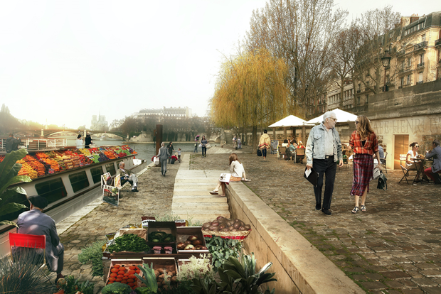
Rendering of a proposed Seine quayside park space. (Luxigon)

Paris seems to be getting less and less motorist-friendly by the day. Following a set of promises to slash diesel usage, extend lower speed limits and bar polluting cars from the city core, Mayor Anne Hidalgo this week announced a plan to thoroughly reclaim the quayside on the right bank of the River Seine for pedestrians. With cars already banished from a long strip of the Left Bank, the Seine in central Paris will as of summer 2016 be entirely encased within two lush, motor-free parkland buffers. Sounding more French than ever, Hidalgo described the plan as “an urban, almost philosophical project, which consists of seeing the city in another way than through the use of cars.”

This is about far more than making things tough for drivers, however. The space freed up from redirecting cars will be broad enough to create a wide promenade, shaded by trees and with space for children’s playgrounds and sports facilities. Covering up to 3.3 km kilometers in total*, this green border will create up to 1.4 acres of new parkland while simultaneously reducing pollution. Judging by the renderings available, it’s going to look and feel delightful. The plan will also correct one of the worst planning mistakes Paris made in the 20th century (more of which later) and, perhaps best of all, probably cost no more than €8 million ($9 million).

This is about far more than making things tough for drivers.
Exactly how long the new quayside park will extend is still up for grabs until a public consultation this June decides on one of two plans. One plan covers a modest 1.5 kilometers, pedestrianizing the stretch between the eastern end of the Ile St. Louis and the western tip of the Ile de la Cité. The other is far larger, creating an additional 3.3 seamless kilometers of car-free quayside from the Pont de l’Arsenal (due South of the Bastille) up to where the riverside road plunges into a tunnel at the Tuileries Gardens, where the quay is already for walkers and cyclists only.

74ce13390.png

Sections of the lower quays of the Seine will be transformed into pedestrian promenades. (Luxigon)
That this is possible without snarling Paris traffic terribly is due to the Seine’s distinctive double-tiered embankment. The Seine actually has two separate lines of quayside. One stands above the river at street level and the other is right down on the water, sunk below high walls that separate it from the rest of the city. These two levels created a split personality for the river as it was steadily formed by embankment from the 17th century onwards. While the upper level became an attractive, salubrious promenade populated by strollers and booksellers’ stalls, the lower bank remained a commercial affair where barges offloaded their cargo.

This changed in the 1960s when, pursuing what was then considered good policy, Parisian planners started looking for new ways to speed cars into the city center. The existence of the un-built lower quays must have seemed miraculous back then—Paris could find space for four new traffic lanes without even having to demolish a single building. Certainly, converting them into roads was a lot less destructive than what took place in other cities, so often a slash and burn carving of new motor lanes into the historic fabric. At least the roaring noise the new mini-highways created was muted by being sunk down below embankment walls, while some stretches were actually encased in tunnels. Nonetheless, something was unquestionably lost. Beyond far dirtier air for central Paris, people seeking out the city’s sense of romance found themselves looking down from ancient bridges onto a screeching speedway.

c65d060ff.jpg

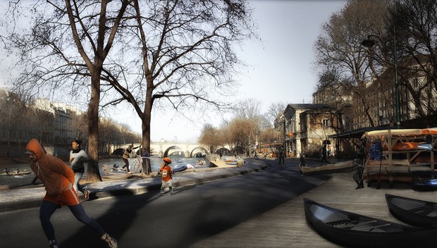
Rendering of a future recreation-focused Seine quayside. (Luxigon)
The long overdue turnaround began in earnest just after the millennium. In 2002, Paris started closing down sections of the quayside to create a temporary summer beach, complete with real sand and sun loungers. Now spread to three sites along the river, the Paris Plages scheme hasn’t just shown how delightful the riverside can be, it has proved that the city could divert motor traffic without kick-starting Armageddon. Taking note, the city barred cars permanently from a long stretch of the Left Bank in 2013 to create a waterside park. The results of this plan are already impressive: 4 million visitors in its first 18 months and a 15 percent reduction in local nitrous oxide pollution.

While this sounds great, opponents point out an obvious pitfall. Closing down motorist routes doesn’t automatically reduce pollution—it can also just displace or intensify it in other places. So what will Paris do if cars banned from the quayside start to clog up other roads even more? Hidalgo is promising an as yet un-clarified improved public transit offer to help mop things up, but overall she suggests that the best new alternative location for cars may be the scrap yard. Discussing plans for future traffic flow, she had this to say:

"All this is part of a comprehensive policy in which we assume very deliberately that there will be fewer cars in Paris. Therefore in calculating the flow of spillover traffic I don’t project myself into a world where there are as many cars as today. Objectively that will no longer be the case."
 
Montreal's highway burial is an unmitigated success compared to the alternative of blockbusting Old Montreal and running an expressway through it. We should be doing the same kind of burial in Toronto of our expressways. We also seem really slow on the uptake when it comes to development opportunities over transit corridors. Our rail lines west of the CN Tower are ripe for development. A similar opportunity is there for a trenched Gardiner and Allen. I think removal without replacement is possible east of Jarvis, but complete removal of the Gardiner without replacement can't work right now. Our society is too geared up for the automobile. Even if we move to smaller electric cars, it's unrealistic to dispense with personal vehicles any time soon. They represent independence, personal expression, and freedom to many. I'd like to eventually see removal of the Gardiner from Strachan to the DVP, but there would need to be new off ramps in place from the Western Gardiner, probably to a new Front St. extension west of Bathurst. Without that key piece of infrastructure, removal would be near impossible. Complete removal becomes more realistic if there are off ramps on Front and farther north, say at Adelaide and Richmond just east of Bathurst. But who builds and pays for this infrastructure? That's where an Allen Expressway extension could come in. An underground toll Allen Expressway running to the western Gardiner would provide the on/off ramps we'd need from the Gardiner. If the tunnel incorporated a subway line (paid for by Allen Expressway tolls), we'd also get a substantial portion of our DRL built.

A final important piece of the puzzle, I believe, would be an intermodal station at the Bathurst Rail Yard. Have the west end of the ST/GO RER platform situated just west of Bathurst, where it would connect with the last station of this new subway line. Also have a large parking facility on those vacant former industrial lands west of Bathurst, so that drivers could exit the Gardiner or Allen and get on transit. The east end of the ST/GO RER platform would service the new Well development and City Place. Maybe this would be enough for the city in the coming decades, to have a segment of the Gardiner between just east of Yonge and Strachan remain elevated with the Under Gardiner/Bentway and a greening of the elevated highway, and either a trenching or complete removal of the Gardiner east of Jarvis. If off/on ramps were built for the elevated Gardiner between Strachan and Bathurst to Front St., we would get a chance to see, when the Gardiner is closed to the east for maintenance, how traffic fairs without the elevated Gardiner. If it no longer seems necessary, it could be removed. Personally, I'd rather see an underground toll Gardiner in place before removal (maybe under Richmond and Adelaide streets? maybe incorporating the DRL?), but that's likely too ambitious. Having intermodal stations (providing relief for Union) in both the east (at Unilever) and west ends of the downtown core (Bathurst), accessible by highway, makes it possible to reduce both the number of cars and the amount of congestion in the core.
 

Back
Top