


pman
Senior Member
Sadly, I have to agree with you.Photo radar? The province may not acquiesce even if Tory wanted it. I will believe it when I see it.
AoD
|
|
|
Sadly, I have to agree with you.Photo radar? The province may not acquiesce even if Tory wanted it. I will believe it when I see it.
AoD
https://www.thetimes.co.uk/edition/news/automatic-speed-limits-planned-for-all-new-cars-7lrfkzv3dAutomatic speed limits planned for all new cars
Safety groups hail biggest overhaul in 50 years
Graeme Paton, Transport Correspondent
March 27 2019, 12:01am, The Times
All new cars will be fitted with devices that make sure they automatically keep to the speed limit in a move billed as the biggest overhaul of road safety in more than 50 years.
Within the next three years, models sold in Europe are expected to use technology that detects limits and slows down vehicles travelling too fast.
It will be one of 15 new safety features fitted as standard to cars, HGVs or buses. Other measures include technology that detects when drivers are losing concentration or falling asleep, a system that keeps cars in the centre of lanes and accident black boxes that record vehicle movements.
All cars will also be fitted with automatic emergency braking, which brings vehicles to a stop when pedestrians step into the road or a car ahead suddenly slams on the brakes.
The measures were approved by the European Commission and are expected to be rubberstamped by the European parliament and member states in September. The UK government has already said that vehicle standards will be aligned with those in the EU after Brexit, meaning that the same rules will be expected on British roads.
Road safety groups described the measures as possibly the biggest single improvement since front seatbelts were made compulsory. However, the AA warned that “intelligent speed assistance” could prove problematic if a vehicle is suddenly slowed down when another car is driving too close behind.
The changes will be applied to all wholly new models of cars by 2022. New versions of existing cars will be fitted with the technology from 2024. Many new cars, particularly premium models, already have some or all of the systems.
Nine in ten crashes are believed to involve some form of human error.
Speed assistance uses GPS technology to detect the limit on a road. A vehicle driving too fast when a speed limit changes will be automatically slowed down, which campaigners hope will help to change motorists’ behaviour.
It will not be possible for the driver to switch off the system completely. However, in a move designed to smooth public acceptance of the technology, drivers will be able to override it when it kicks in by pushing down on the accelerator. This will allow motorists to overtake a vehicle just in front.
The move follows the publication of figures by the Department for Transport showing that 4,805 accidents were logged in 2017 in which the driver was exceeding the speed limit. Of those, 203 involved a death, representing one in seven fatal crashes on British roads.
Volvo announced weeks ago that it would roll out technology to limit the top speed of cars to 112mph from 2020.
Edmund King, president of the AA, welcomed measures such as automatic emergency braking but warned: “This sort of technology can be problematic when you suddenly switch from a 40 to 30mph zone and there is a taxi right on your tail. Quickly slowing right down isn’t always the wise thing to do,” he said. “It also relies on ensuring that it has a very comprehensive and up-to-date map of all speed limits. What happens when you enter roadworks and the car allows you to go too fast?”
Joshua Harris, of Brake, said: “These measures will provide the biggest leap forward for road safety this century, perhaps even since the introduction of the seatbelt. These lifesaving measures come at a vital time, with 70 people still being killed or seriously injured on British roads every day.”
Elzbieta Bienkowska, the EU commissioner for industry, said: “Every year 25,000 people lose their lives on our roads. The vast majority of these accidents are caused by human error . . . With the new advanced safety features that will become mandatory, we can have the same kind of impact as when the safety belts were first introduced.”
A Department for Transport spokesman said: “We continuously work with partners across the globe to improve the safety standards of all vehicles. These interventions are expected to deliver a step-change in road safety across Europe, including the UK.”
Drive to eliminate the dangers
The European Commission plans 15 new safety features from 2022 including:
Alcohol interlock installation facilitation
Prevents motorists driving when over the drink-drive limit. Breathalysers can be installed for previous offenders.
Drowsiness detection
Warns tired drivers to take a break.
Lane-keeping assist
Monitors a vehicle’s position and moves it to the centre of the lane.
Event data recorder
Like an aircraft black box, it allows data to be accessed after a crash.
Direct vision
Makers of HGVs and buses must fit bigger windscreens and side windows so drivers can see cyclists.
Road users driving in term time face delays of up to 15 minutes thanks to parents taking their children on the school run.
A new study by Admiral, a car insurer, has revealed that traffic levels increase by almost a fifth during the school year.
In 2018 UK road users lost about £7.9billion and 178 hours as a result of being stuck in traffic.
The study found that 80 per cent of people dropping children off at school by car could in fact use alternative transport that wouldn't clog the road.
Less parents doing the school run also equated to less road accidents, as it was revealed that there were 43 per cent less collisions during school drop off times in the holidays.
Those in Northern Ireland have the longest term-time commute at 43 minutes, with an extra 21 minutes for those doing a school drop off.
Commuters in the north-west of the country benefit the most from school holidays with their average commute time dropping from 41 minutes to 25.
Nearly half of those surveyed said they were late to work due to traffic at least once a month.
London was the most congested city in the UK with drivers losing an average of 227 hours thanks to traffic.
London was ranked the sixth most congested city in the world, behind Moscow, Istanbul, Bogota, Mexico City and Sao Paulo.
Commenting on the findings, Sabine Williams, head of Motor at Admiral, said: 'Our investigation has laid bare the impact of the school run on the morning commute, with proof that dropping children at school or nursery is affecting all commuters, both those with and without children.'
Steve Brooks, Wales' Director of UK sustainable transport charity, Sustrans, said: 'It's not surprising that research has found there are less traffic collisions during school holidays.
'Currently, roads outside schools are overcrowded and congested. This congestion is also affecting air quality with four out of ten children breathing toxic air at school.
'By improving and investing in better walking and cycling infrastructure, we could see an increase in children walking and cycling to school, lessening the amount of cars on the road during the school run.
'Reducing the number of cars is a key way to tackle the ongoing problem of congestion.
'The average school journey is 1.6 miles and yet one in four cars on the road during the morning peak are doing the school run.
'This distance could easily be travelled by walking, scooting and cycling to help tackle congestion and to improve air quality.
'Governments across all levels need to support families and schools to make walking and cycling possible and implement investment in walking and cycling paths and training programmes.'
Sustrans runs a programme called Sustrans School Streets which aims to encourage more street closures around schools to help parents use alternative methods to take their children to school.
 www.toronto.ca
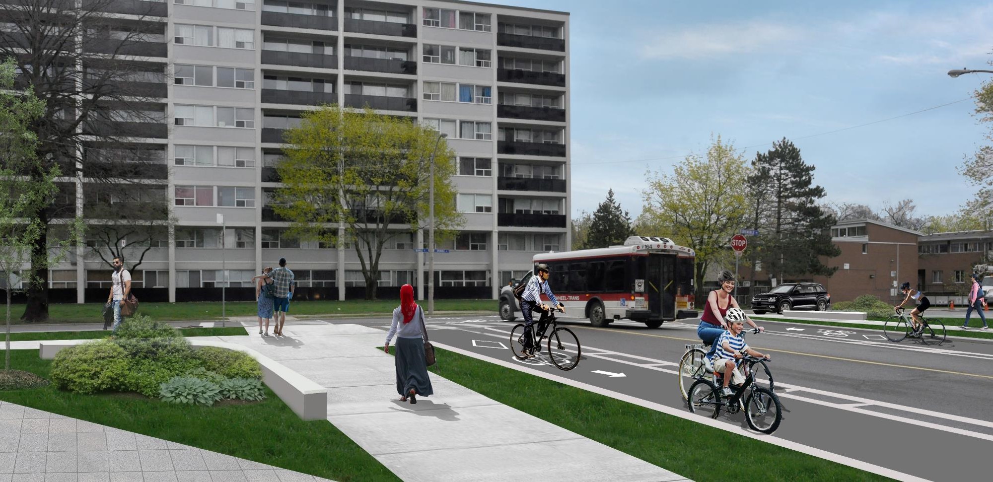
Much needed intersection design improvements are coming to Flemington Park.
View attachment 188413
View attachment 188414
"Rendering of potential Vision Zero improvements at Deauville Lane and Grenoble Drive. The right-turn lanes will be replaced by trees, plantings and places to sit. People walking and cycling will have shorter distances to cross the street."
View attachment 188415
"Rendering of potential Vision Zero improvements at Deauville Lane and St. Dennis Drive. The right-turn lane will be replaced with corner safety islands to slow turning vehicles and separate motor vehicles from people on foot and bike. People walking and cycling will have shorter distances to cross the street."
Additional info here:
Deauville Intersection Improvements
Starting August 7, the intersection at Deauville Lane and Grenoble Drive will be closed to vehicle traffic. Designated crossing areas for pedestrians and people cycling will be provided. See the Construction Update Notice in the News & Updates tab. The City of Toronto is planning to...
IIRC there was some pretty explicit council instruction to install some last year - a direct motion requiring them. They exist in Ottawa so Transportation Services doesn't have the "HTA doesn't permit it" backstop to fall on..omg the corner safety islands -- I didn't know the City's Transportation department even knows what those are (though I'll be pleasantly shocked if they wind up actually implementing them).
Interesting that the first location is in Flemingdon Park of all locations though.
In Beijing, Chennai and Fortaleza, the rate of fatalities from road crashes is 20-27.2 deaths per 100,000 residents. What do these cities have in common? They have traffic lanes wider than 3.6 meters (11.8 feet). A long-standing belief among transportation planners and engineers is that wider traffic lanes ensure safe and congestion-free traffic flow. Recent academic research, highlighted in Cities Safer by Design, a WRI Ross Center for Sustainable Cities publication, shows that wider lanes are more dangerous than narrower lanes. To further investigate how cities are stacking up against the existing evidence, the Health and Road Safety team of WRI Ross Center for Sustainable Cities decided to compare typical lane widths in selected global cities with reported traffic fatality rates.
How Wide Should a Traffic Lane Be?
WRI’s research shows that cities with travel lane widths from 2.8 to 3.25 meters (9.2 to 10.6 feet), such as Amsterdam, Copenhagen and Tokyo, have the lowest crash fatality rates per 100,000 residents. However, many cities, specifically in the developing world, have wider lanes and higher fatality rates.

New Delhi, Mumbai and São Paulo have wider lanes, ranging from 3.25 meters to 3.6 meters (10.6 to 11.8 feet), which leads to a fatality rate of 6.1-11.8 residents per 100,000, while Beijing, Chennai and Fortaleza have the highest fatality rate, 20-27.2 deaths per 100,000, with lane widths of 3.6 meters (11.8 feet) and higher.
But Why Are Wider Lanes Misinterpreted As Safer?
For decades, transport engineers and planners have considered wider lanes safer, as they provided higher maneuvering space within the lane and were said to help prevent sideswipes among cars. Yet, in an urban setting, this means cars may go faster, and, when cars go faster, the likelihood of crashes and injuries increases. For example, if a car is traveling at 30 km/h (18.6 mph), pedestrians have a 90 percent chance of survival, but, if the car is traveling at 50 km/h (31 mph), there is only a 15 percent chance the struck pedestrian will survive.

Narrower travel lanes, coupled with lower speed limits, can foster a greater sense of awareness among drivers. Narrower lanes also ensure shorter crossing distances for pedestrians at intersections, which reduces the risk of an accident.
Do Wider Lanes Help to Reduce Congestion?
In 1963, Lewis Mumford said: “Increasing road width to reduce congestion is the same as loosening your belt to fight obesity.” In fact, increasing road space by having wider lanes doesn’t reduce congestion due to rebound effects. More road space results in generating more traffic. Research shows that 3 meter-wide lanes have 93 percent of the road capacity of 3.6 meter lanes—not a noticeable difference. In addition, if narrower lanes reduce speeds, this should not put great strain on vehicle movement. A recent study from Grenoble shows that private vehicles take only 18 seconds longer to travel a kilometer on a road with speed limit of 30km/h as compared to a road with a speed limit of 50km/hr. Moreover, signal delays at intersections create congestion—it rarely depends on mid-block traffic flows.
How Would Road Dieting Help?
Road dieting is a technique of narrowing lane widths to achieve sustainable and safer pedestrian and cyclist environments. If cities embrace narrower lanes, there are a range of possibilities for re-designing city streets to make them safer and more accommodating for pedestrians and cyclists.
But Why Aren’t 3 Meter Lanes the Norm?
Most cities in developed countries, like the United States, follow road design guidelines from standard-setting bodies like the American Association of State Highway and Transportation Officials’ A Policy on Geometric Design of Highways and Streets, commonly known as the Green Book, which actually allows lane widths to vary between 10-12 feet (3.0 to 3.6 meters). While the book provides a range, engineers tend to design streets with the maximum lane width, due to the ill-informed notion that wider lanes are safer and can help reduce congestion. Many cities in low- and middle-income countries have adopted this same approach, erring on the supposed side of caution.
Today, with new research showing the opposite of the status quo and a rising interest in cycling, walking and bus systems, it is time for cities to reassess how their own standards foster a safer and healthier city.
