Rather than having to reclaim the "Leiside Spur trail" for rail use, would it be possible to curve north to merge with the other line where it crosses the DVP here:
https://goo.gl/maps/RMR9PFP9KEv
Maybe that is what you are saying when you said "The other northern option would be to route off north at 1/2 mile bridge and back down to the Bala sub, while likely staying on a bridge until across Pottery Road.", but I don't know the locations of these different lines and bridges.
On the southern portion, new tracks would hug the DVP south of this point:
https://goo.gl/maps/Xboyw1mRup82
South of this point:
https://goo.gl/maps/qbeKDBunVT82 , the DVP would need to be shifted east by creating 2-3 new lanes, allowing for the new rail to be laid on the east side of the river
The construction staging would first have the new lanes built, then the highway shifted to allow for the new rail to be put in.
I don't know if this is part of the plan, but I've been looking closely at the renders and trying to piece together what it is.
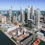
the following map is vegeta_skyline's from post #4920 at
http://urbantoronto.ca/forum/threads/go-transit-service-thread-including-extensions.4952/page-328, and the renders below are from the article in the original post.
View attachment 73325View attachment 73326 View attachment 73327