


sixrings
Senior Member
Option 1 or branch and do option 1/3.
|
|
|
The main question is where the west arm of the DRL should lead. Here’s an overview of the leading options:
...
3)Continue to Dundas Station. Connect with Line 2 and UPX. Extend NW to Junction, Stockyards, etc.
Routes that follow Queen then go to Dundas West are fine for connecting together the regional system, but they increase service on corridors that are fine-grained and are well served by streetcars, while ignoring the growing density on King, Front, and Dufferin. 2035 solutions for 1935 problems.
Routes that follow Queen then go to Dundas West are fine for connecting together the regional system, but they increase service on corridors that are fine-grained and are well served by streetcars, while ignoring the growing density on King, Front, and Dufferin. 2035 solutions for 1935 problems.
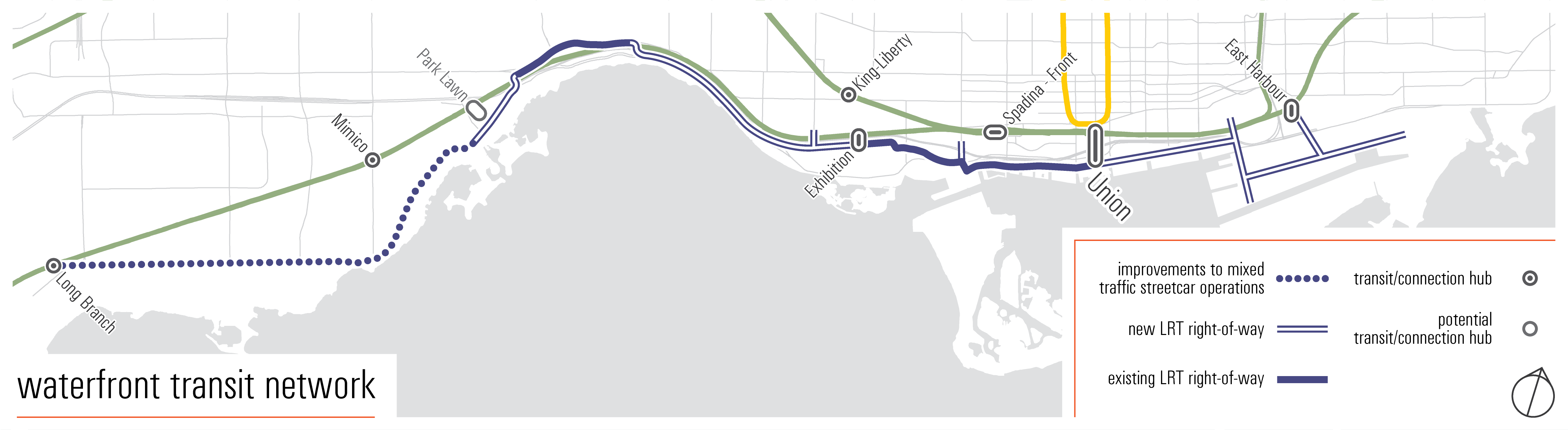
Would a King Streetcar ROW Extension be not enough?DRL west has to hit the Queen/King/Roncesvales/Queensway intersection. Perfect place for a sunnyside transit hub with lakeshore west GO, lakeshore west/queensway LRT, Queen streetcars, King streetcars and DRL converging together. There is also a streecar maintenance facility already owned by TTC that can be redevelopped into a station. There is a local destination with st Joseph's Hospital. All the transit traffic from humber bay shore, south etobicoke and the lakeshore west GO has to have the option to transfer to the DRL. I think going up dufferin would be a big mistake.
Yes, although realistically the Go/CN Corridor might make more sense than Roncy.The last western relief line route I've seen officially considered would go west on Queen/King, up through Roncesvalles and hit Bloor at Dundas (see pg 29 of linked report). Is this your third option?
http://www.metrolinx.com/en/docs/pdf/board_agenda/20150625/2015-06-25_Yonge_Relief_Network_Study.pdf
View attachment 171983
DRL west has to hit the Queen/King/Roncesvales/Queensway intersection. Perfect place for a sunnyside transit hub with lakeshore west GO, lakeshore west/queensway LRT, Queen streetcars, King streetcars and DRL converging together. There is also a streecar maintenance facility already owned by TTC that can be redevelopped into a station. There is a local destination with st Joseph's Hospital. All the transit traffic from humber bay shore, south etobicoke and the lakeshore west GO has to have the option to transfer to the DRL. I think going up dufferin would be a big mistake.
Brain dead.Isn't Smart Track dead?
It makes perfect sense, as it can emerge from underground to run on existing tracks *if* the entire Relief Line is part of Rapid Rail (formerly RER) as standard gauge track single deck EMU. It can then connect downtown to the distant regions all in one trip and completely by-passing (other than station interchange) the present subway. The TTC surface fleet would distribute passengers locally from stations. This could then be Rapid Rail to Bramalea one end, and York Region (Richmond Hill perhaps) the other. In doing so, it would greatly alleviate the groaning subway, and render massive improvement schemes (e.g: Bloor-Yonge) as redundant beyond tweaks and elevators, etc.Yes, although realistically the Go/CN Corridor might make more sense than Roncy.
So you’re saying the Relief Line should go from the north on the east to the south on the west, and another line should go from north on the west and south in the east?I don't think routing the line along the GO/CN corridor makes sense. It misses Liberty Village, the Exhibition grounds, the Dufferin Mall redevelopment, etc. in favour of a route that's already being served by not only Line 2, but also GO and the UPX.
The entire area between High Park and University doesn't need to all be served by the same metro line. A Sunnyside/Roncesvalles/King transit terminal would be a very beneficial for southern Etobicoke (and maybe even southeast Mississauga if there's a waterfront LRT extension into Port Credit). Extending the line due west instead of curving upwards would also allow for a direct link between West Queen/Humber Bay and the Don Mills corridor.
From my perspective, I don't believe the Relief Line will end up being standard gauge, if only for the ability to share facilities with Line 2. If this is the case then it would be better for Toronto's metros to fully diverge from the downtown. If necessary, another line can be drawn north-south to connect to the relief line, Line 2, and Line 5.
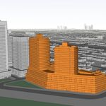
This new SmartTrack station on the Kitchener GO Rail Corridor will be a focal point for a dense urban neighbourhood that has developed over the past 15 years, providing local residents fast and frequent transit access to downtown Toronto. The station itself will bridge the divide between the north and south sides of the rail corridor, by completing missing links in the pedestrian and cycling networks. Pedestrians and cyclists will also be able to use these links to access the station itself. Enhanced connections to the existing Exhibition GO Station are also planned to provide an important link between SmartTrack and the Lakeshore West GO Rail Corridor.
- Pedestrian and cycling access to the station will be provided from both sides of the rail corridor through public realm enhancements and tunnel connections. Enhancements being explored include an extension of the planned West Toronto Railpath and a new overpass of the rail corridor (King Highline). It will also be important to have excellent connections between this station and the Exhibition GO Station.
- The station will have good linkages with surrounding roadways including King Street West and Sudbury Street.
- Connections are planned with local transit routes to provide good station access for transferring passengers, including the 504 King and 501 Queen streetcars.
- [...]