News   Nov 22, 2024
 398     1 
News   Nov 22, 2024
 828     4 
News   Nov 22, 2024
 2.1K     6 

Ontario Line Extension West of Ontario Place (Speculation)

Another thing I think we will need is an actual alternative to a Yonge Subway. I’m talking about a probably-deeper express subway aligned with Line 1 that stops only at Union, DRL, Bloor, Eglington, Shepard, Richmond Hill.

I've never heard of a new express pair of tracks being built under an existing subway, and assume that would be extremely expensive and very disruptive.

The best bet is to use the surface section of the Yonge line near Davisville to decouple the northern part of the line from the central section. The northern trains from Finch (or, Richmond Hill) would reach Davisville and then take a new limited-stop route to downtown, likely built under Bay Street. While the "original" Yonge subway would operate from Eglinton towards Union.
 
It makes me cringe to see people suggest the Queensway/Lakeshore as a potential routing. Line 2 is no where near capacity west of the Humber during rush. The 80 Queensway runs every ~20 mins during rush. Yes, Park Lawn needs additional transit connections.. The planned GO station will give them downtown bound trains every 15 mins. A waterfront LRT to the nearest DRL station will provide an additional connection that should provide significant improvement to the current situation.

Meanwhile south of Bloor in the west end of the Old City, you have:
-63 Ossington operating every 3 mins peak, 22,000 riders over ~7km = 3,142 riders per KM
-47 Lansdowne operating every 4 mins peak, 15,000 over ~10km = 1,500 riders per KM
-29 Dufferin, 44,000 over ~12km = 3,666 riders per km

A corridor 1.5km wide with 2014 ridership at 81,000 riders, with not one stop downtown.

It is important to remember that the Roncesvalles corridor is not a central corridor, it does not see the level of riders as the Lansdowne-Ossington corridor. Nor does it offer the opportunity to relieve all 4 streetcar routes midway into downtown. If you combine the number of riders currently using the Dufferin corridor, with the potential riders who will transfer from all 4 Streetcar routes (5 if the Line is extended to St. Clair), this line would be well used today, IMHO.

It's also important to remember, University south of Bloor is ~at capacity during peak. Line 5 and Line 7 will feed into University when they open in 2 and 4 years respectively. This is a problem that we should foresee.

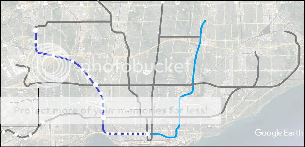
A Dufferin-Jane alignment could offer a long term solution to many of the problems we've collectively identified. This map includes GO lines, proposed GO stations as well as Line 5 and 7 in their entirety for context. The dark blue line is the DRL West. This is a longer version of the previous map I posted on Page 1.

View attachment 173714

I too feel that Dufferin is the best route for RL west. It would be located roughly half-way between the Spadina line and the Weston rail corridor which (hopefully) will see frequent service.

And, it would help de-crowd the Dufferin bus. There is no room for R.O.W. on Dufferin south of Eglinton, and that leaves few hopes to alleviate the crowding save for building underground transit.

I like your map, only a bit unsure about the north-most section. Should it go up Jane to Finch, or rather continue north-west to serve Rexdale (Albion Mall). Anyway, it will be very long time before this becomes a practical question.

I see the reasons for wishing to send RL West along Lakeshore and into the southern Etobicoke, but the Dufferin corridor appears to have greater immediate need.

Speaking of northbound routes other than Dufferin: Roncesvalles will be difficult to build as far as I know (conflicts with the war monument), while Parkdale should be easy to build, but it is away from the existing demand.
 
Pending construction of the Missing Link along the 407 corridor, I've always figured re-routing the Milton GO line under Queensway would be a better alternative to a TTC subway. That line could veer south to the Queensway after Dixie station and travel underground until the Humber River, re-emerging with the Lakeshore GO line until Union. GO combined with a Queensway LRT would be more than sufficient to serve that areas future transit requirements while also creating a better link between Union and central Mississauga. A short branch would even create a direct Square One - Union link as well.

That's an interesting idea, and it might not even have to wait for the 407 bypass.

I would consider a new mainline electric rail service built as follows:
- Tunneled from Mississauga's Square One to Sherway Gardens, and then to the Lakeshore West corridor somewhere west of Mimoco
- Surface / in the Lakeshore West corridor from Mimico to just east of the Exhibition station
- Tunneled through downtown under Wellington or King

Some or all of the Lakeshore West and East service could be re-routed through that new downtown tunnel, too, in order to relief Union.
 
Another thing I think we will need is an actual alternative to a Yonge Subway. I’m talking about a probably-deeper express subway aligned with Line 1 that stops only at Union, DRL, Bloor, Eglington, Shepard, Richmond Hill.
Absolutely necessary, even if not aligned with Line 1. It must *alleviate* Line 1 even if not proximous...and more! Done right, it would also alleviate Union Station if it loops through the core in a huge 'U' shape, using in part the presently proposed RL South. And it must connect right into the exurbs, and the way to do that is on extant mainline trackage, using standard gauge metro or RER type vehicles running on Metrolinx track. Agreed on wider spaced stations. Allow buses and LRT/streetcars to service the nearest station. Not everyone can have a 'local station'...but every neighbourhood can have one, especially where it intersects with other major transit infrastructure.
Parkside is an unique opportunity to afford builders a relatively cheap route between Queen and Bloor Streets though (cut-n-cover, optional if a Howard Park/Parkside Station midpoint is even needed).
Absolutely agreed on Parkside, but I see that as a streetcar link from the Queensway up to Keele Station...or short of that, an express bus, as described in the 'streetcar forum' from the Queensway/Parkside Dr underpass up to Keele. That could be instituted in a matter of a year or so for a very small cost. Queen Cars could turn at Roncy and do that stretch, the King Car could then do the Queensway stretch to the Humber Loop, with other semi-express connections up to the subway, like Windermere/Runnymede. Heavy rail isn't needed for that area, streetcar/bus could serve it just as well or better.
And there isn't much at Dundas and Dufferin to warrant serving with a metro, tbh.
Dufferin is a tough one, but no matter how that nut is cracked, it shouldn't be done with a Relief Line. Dufferin needs far too many local stops. I see surface LRT/streecar (with short stretches in tunnel) as being the solution. There should be a stop to service Dufferin/Queen, but the line should remain Northwest/East by utilizing the Georgetown Corridor by using the surface RER alignment to Bramalea that end, and Richmond Hill the other, tunnel existing between Parkdale and Don Mills/Leaside where it emerges to assume the present Richmond Hill line. Peak service double decker GO trains would continue to use the Don Valley into Union, the RER would run all day via the core loop up to Bramalea. This approach is used in many world cities, either as an RER or metro.
From a network perspective it makes total sense.
(In answer to @north-of-anything 's "The Finch West line can easily be extended to service the Woodbine area") "Network perspective" is absolutely what is needed. I term the Relief Line South, as presently conceived, as the "Pape Entitlement". It does virtually no "relief", and any it would do would be lost to new riders loading other parts of the present system. As to how Metrolinx got this so utterly wrong in the past is mind boggling. Munro discusses that in detail here:
FEBRUARY 5, 2019
Metrolinx Board Meeting: February 7, 2019 (Updated)
And like it or not, using the rail corridors as ROW north of Keele and St Clair far increases the likelihood of it getting built in somewhat immediacy versus 50-75 years from now.
This is a very important point! The *doability* of "Relief" gets bogged down by trying to do everything for everyone. People forget that buses/streetcar to/from heavy rail is the accepted way of life for the majority. We can't cater to select pockets and screw the rest. This is exactly the problem of the "Pape Entitlement". They get subsidized by the swathes of taxpayers in the exurbs while the latter get nothing. And extending the subway just makes everything worse for everyone. Leave the subway as-is (save for necessary tweaks and upkeep) and start building infrastructure to serve *everyone* with everyone's tax money. And that means the sprawling suburbs/exurbs.
Who's going to pay for subways to Maple Leaf, Falstaff, Exbury, Grandravine and Shoreham when we can't even get the traditional DRL funding guaranteed?
Absolutely!

Which brings me to the 'Upload". I see it being best that the upload goes *beyond* Queen's Park. I say let the Feds, via the Infrastructure Bank, assume federal control of the 'Relief Project' using Constitutional power vis-a-vis "For the General Advantage of Canada" (linked and discussed in finer detail in the 'Upload Forum') and then involve massive private investment in a consortium that may or may not include the City and/or Province to build this 'all in one go'...similar to the REM project in Montreal, Crossrail in London, Sydney Metro, in Oz, etc, etc.

This is way beyond Toronto's capability, and it's beyond Ontario's, especially with a 'low spend' QP regime.

Either we think Really Big on this, or we're left with dribs and drabs for the next half century. Again.

Relief Line South is pathetic by its irrelevance to the big picture. The only way to finance what needs to be done is to involve the private sector. That is the Ford mantra. Except it's way beyond him. I trust Private Enterprise to do it right. I don't trust Ford to.
 
Last edited:
That's an interesting idea, and it might not even have to wait for the 407 bypass.

I would consider a new mainline electric rail service built as follows:
- Tunneled from Mississauga's Square One to Sherway Gardens, and then to the Lakeshore West corridor somewhere west of Mimoco
- Surface / in the Lakeshore West corridor from Mimico to just east of the Exhibition station
- Tunneled through downtown under Wellington or King

Some or all of the Lakeshore West and East service could be re-routed through that new downtown tunnel, too, in order to relief Union.
This could be done as a spur to connect the RER as I describe above to the Lakeshore West to allow run-through to the core from the west instead of via Union.

Ditto to the east, if the present proposed route for Relief Line South is used for RER EMU: A link can be tunnelled to connect service eastbound onto the Lakeshore East line. Two points avail themselves for doing this link. The present TTC subway plan (still not cast in stone) would require a number of connecting tunnels, so doing it RER would not increase costs, but add massive flexibility to serving the entire GTHA through the core. The subway would stay intact, no more grandiose schemes to turn a Volkswagen into a Porsche. Just run the VW as it is and until it's completely worn out.
That's an interesting idea, and it might not even have to wait for the 407 bypass.
In the big picture, let alone the present, the Bypass or Link still has to happen. Once it does, it lends itself to all sorts of great options for RER, not least Summerhill Station and VIA HFR as well as RER off the Midtown corridor and down to Union Station.

One more reason for doing this project standard gauge. It will allow through-running in many ways.
 
Except we aren't going to build that so that isn't what is going to happen.
How Toronto of you.

Who exactly is going to build things the way you propose? Toronto? QP? Think again, and think outside the box. I don't know what it takes to wake up Torontonians.

Take a look at REM, just to start. No-one is building orthodox subways anymore. Some lines are being extended in a few places because they're stuck with a heritage choice. And that's it!
Why Won't New York City Build More Subways? - CityLab (by Jonathan English, btw, who's graced UT with some excellent articles on same)

Why don't cities build subways anymore? - Urban Planning

Why New York City Stopped Building Subways - Slashdot

etc, etc...

I say let Private Investment make the choice, built on a business case. It will be their money. Where else is the funding going to come from?

From J. English's City Lab article above:
[...]
Beyond: The high cost of forgotten history
Many other world cities also slowed their pace of subway construction in the early postwar years. They, too, succumbed to the appeal of the automobile, or struggled with debt and destruction accumulated during the Depression and Second World War. But by the 1960s, this had changed. London opened two new Underground lines in the 1960s and 1970s. Paris began its vast RER project to connect all of its commuter rail lines, linking the rapidly growing suburbs with the historic core.
[...]
https://www.citylab.com/transportation/2018/04/why-new-york-city-stopped-building-subways/557567/

London is no longer building new subways save for short extensions. They build what is in effect a 'UK RER': Crossrail.
Before the Tories upload Toronto’s subway, they should take a ride on London’s tube
ANALYSIS: Doug Ford’s government could learn a lot from London about operating a transit system, writes John Lorinc
Published on Oct 18, 2018
by John Lorinc
[...]
https://www.tvo.org/article/current...ubway-they-should-take-a-ride-on-londons-tube

the execution strategy for delivering London's Elizabeth line - Crossrail ...

https://learninglegacy.crossrail.co.uk/.../The-execution-strategy-for-delivering-Londo...

by W Tucker - ‎Cited by 5 - ‎Related articles
The new line, to be named the Elizabeth line when it opens through central London in 2018, is designed to increase the capacity of central London's rail transportation network by 10%, relievingcongestion at a number of existing London Underground stations and at two key Network Rail stations, Paddington and Liverpool
 
Last edited:


Here's an illustration of the alignment I mentioned earlier today. IMO, there's far more trip generators via the Highway 27 alignment (Weston Village, Woodbine Entertainment, Humber College/Etobicoke General Hosp.) than going up Jane, which also can be done for far less expense as it'd be elevated versus tunnel bore underneath Jane Street.

I think the future west end dilemma is another reason why a King St alignment should've been chosen over Queen. That's not to say a subway under Queen isn't necessary (I'd wager both lines will be necessary within 50 years time), but a King alignment would ideally hit Liberty Village GO RER station and swing north along Dufferin. A Dufferin route hits the outer, central core of the old city while also relieving the University line and the various surface routes you mentioned, specifically the Dufferin bus. I believe both subway routes would also allow for a combination of express vs localized routes, with one line containing fewer stops than the other.

A Queen subway would best be suited to traverse Queen entirely, from the Beaches in the east to Sunnyside/Roncesvalles in the west. The Sunnyside stop would ultimately be the Queen line's terminus for some time as any northern/western extensions would depend on development patterns within Etobicoke. Perhaps a northwestern alignment up Parkside-Keele and into Rexdale would be suitable within 75 years. The Sunnyside terminus would serve as a pretty important hub between GO, TTC subway and TTC surface routes.

Pending construction of the Missing Link along the 407 corridor, I've always figured re-routing the Milton GO line under Queensway would be a better alternative to a TTC subway. That line could veer south to the Queensway after Dixie station and travel underground until the Humber River, re-emerging with the Lakeshore GO line until Union. GO combined with a Queensway LRT would be more than sufficient to serve that areas future transit requirements while also creating a better link between Union and central Mississauga. A short branch would even create a direct Square One - Union link as well.
If FWLRT was not built, I would vote for the Albion Rd. Route. To get from roughly 401/Weston, to Islington Albion, would be 3.5km - too big of a gap (and 401/Weston is not a great location either. The possible stations along Jane do look better.
ttc.jpg Population Density
 
Last edited:
Another thing I think we will need is an actual alternative to a Yonge Subway. I’m talking about a probably-deeper express subway aligned with Line 1 that stops only at Union, DRL, Bloor, Eglington, Shepard, Richmond Hill.

This is half of why an RER Relief Line is so good. Joining the RH line north of Lawrence and running sub 5 minute frequencies to Richmond Hill GO produces, for all intents and purpose, the same thing as a Yonge express.
 
This is half of why an RER Relief Line is so good. Joining the RH line north of Lawrence and running sub 5 minute frequencies to Richmond Hill GO produces, for all intents and purpose, the same thing as a Yonge express.
That, and a whole lot more, for virtually the same cost as building a toy subway. Due to the non-standard nature of a lot of TTC subway stock, universal RER stock will actually be cheaper, and much more appealing to investors. On the basis of supplying their own stock, a large supplier could be very interested in being a major shareholder of a consortium.

Best I post examples of this, since most Torontonians haven't a clue as to how others are doing this:
1550032302407.png

A landmark in infrastructure funding. ... The difference is that Rapid Metro is India's first fully privately funded metro system. The project was financed by the Infrastructure Leasing and Financial Services (IL&FS) group, while the core rail systems for Rapid Metro were delivered by Siemens.Oct 1, 2015
On track to financial viability - Cities - Home - Siemens Global Website
https://www.siemens.com/customer-magazine/en/.../on-track-to-financial-viability.html

Why Tokyo's Privately Owned Rail Systems Work So Well - CityLab
https://www.citylab.com/transportation/2011/10/why...privately...rail-systems.../389/

Oct 31, 2011 - There are megacities, and then there's Tokyo. With a metro-wide population of 35 million, it's the undisputed king of megacities, comfortably ...

On track to financial viability - Cities - Home - Siemens Global Website
https://www.siemens.com/customer-magazine/en/.../on-track-to-financial-viability.htm...

Oct 1, 2015 - A landmark in infrastructure funding. ... The difference is that Rapid Metro is India's first fully privately funded metro system. The project was financed by the Infrastructure Leasing and Financial Services (IL&FS) group, while the core rail systems for Rapid Metro were delivered by Siemens.
[PDF]Innovative financing techniques: European urban rail ... - Polis Network
.pdf'].pdf'].pdf']https://www.polisnetwork.eu/uploads/Modules/.../Innovative_financing_tec[1].pdf

by A Deloukas - ‎2003 - ‎Cited by 3 - ‎Related articles
PROJECTS AND THE CASE OF ATHENS METRO EXTENSIONS. A. Deloukas, E. ... completion (e.g. through a privately placed long bond). A variant of this DBFT ..... Urban rail systems contain also a high level of complexity. This implies high ...
etc...

But beware! The Simpsons and the Monorail Episode still applies, and this is my massive concern with the Ford fiasco unfolding:
IL&FS Scam: Gurgaon’s Rapid Metro Was Based on Entirely Fraudulent Numbers

Sucheta Dalal
23 November 2018 8

The spanking world-class Rapid Metro, which became operational in Gurgaon (now Gurugram) in 2013, has certainly added lustre to the modern township built by DLF. But the project is based entirely on fraudulent and fabricated ridership claims, to get government sanctions, right of way for land use and other benefits.

The metro project was conceived by DLF, the realty giant, and mid-wifed by the scandal-hit Infrastructure Leasing & Financial Services (IL&FS). They are also the two biggest beneficiaries. India’s public sector banks (PSBs), as always, are stuck with the bad loans of this gold-plated project.

Here is how it unfolded. DLF originally proposed a 3.2km metro project between Sikanderpur and National Highway-8 (NH8) to the Haryana government in September 2007. It hired IL&FS to prepare the Detailed Project Report (DPR) as a consultant. This was submitted by DLF to the Harayana government's town and country planning department.

Metros, even elevated ones, are expensive showpiece projects and ought to be considered by smaller cities only when other modes of public transport are inadequate to meet growing transportation demand. But when you have a powerful corporate, captive government and pliant bureaucrats, all good sense is thrown to the wind. [...]
https://www.moneylife.in/article/il...sed-on-entirely-fraudulent-numbers/55792.html

Sound familitoid? Beware Doug Ford's follies! Ssssscarborooooo

Learn from other nations, like Oz, the UK, NZ, European nations, Japan, HK, etc, where the model wasn't perfect, but highly successful, bold and built!
 
Last edited:
My main concern is that the Relief Line West will most likely be just that, the western extension of the Relief Line. I'm operating under the assumption that the Relief Line will end up using TTC gauge, if only for compatibility with existing facilities (especially at Greenwood). If that's the case, I think duplicating the Kitchener corridor is a waste of space and money, and it would be much more crucial to hit areas to the south of Line 2, like St. Joseph's Hospital.

I think the Relief Line as a separate line along Don Mills is necessary as a counterpart to the University leg of Line 1, in the absence of a reliable north-south corridor between Yonge and Scarborough. I don't think it will be GO-style rail based on what I'm perceiving public opinion to be.

But if it somehow does become an RER tunnel of some kind, there's another possibility here - three prongs of rail service heading both west and east from downtown: Lakeshore in both directions, Kitchener and Barrie to the west, and Stouffville and Don Mills(?) to the east. From there, it might be possible to even transform Line 2 into an underground section of the current Milton GO line, which might make a Dundas West hub more plausible, and also maybe mitigate Bloor-Danforth's current "second banana" status.

I think a lot of things would need to go right for this to happen, though. I'm not saying my Queensway to Dixie extension is the ideal solution; I'm just naturally suspicious of the effectiveness of mass transit promises in the GTA.
 
But if it somehow does become an RER tunnel of some kind, there's another possibility here - three prongs of rail service heading both west and east from downtown: Lakeshore in both directions, Kitchener and Barrie to the west, and Stouffville and Don Mills(?) to the east. From there, it might be possible to even transform Line 2 into an underground section of the current Milton GO line, which might make a Dundas West hub more plausible
You're considering the bigger picture, which no matter what this turns out to be, will make it much more attractive for private investment, which like it or not, is going to be the life blood of this. Do it small, it won't show the return on investment necessary for investors to participate. Do it big, and the cost to yield ratio goes up proportionately, it'll be a lot more viable, for all concerned.
I'm just naturally suspicious of the effectiveness of mass transit promises in the GTA.
You have every reason to be.

Even seeing a large and attractive business case made with the Relief Line in entirety, it's going to have to cover a lot of other suggested needs to maximize return. I don't see many of the other projects coming close to the demand this will satisfy. Done right, it will save vast amounts for many of the other band-aid solutions.

Complementary to this, I see the Missing Link/Freight By-Pass as also having a much greater return than cost ratio and also done with private capital (I include Infrastructure Bank participation as 'private'). Unlocking the remaining freight lines in Toronto for RER and VIA HFR use will be the key to transform Toronto into what other world cities now have.
 
Some very solid ideas here. A few suggestions:

- There aren't enough stops. DRL west should have stop spacing similar to line 2. I would add stops at Bathurst and Queen, at Dundas and College with an underground connection to Dufferin Mall, and maybe one at Dufferin and Davenport (close to George Brown?).

- The line misses Parkdale and the important connection to multiple lines at Roncesvalles. How would you address this gap?

- Perhaps Dufferin should get its own subway line while the DRL serves Parkdale, Roncy, the massive coming density hub at Dundas West, the Junction, the Stockyards, then veering north-west to Mount Dennis, Weston, and up Jane into North York as you proposed.

- Taking DRL along the Queensway is insane overbuilding. A surface LRT ROW west from Humber Loop to Sherway is the solution there.

Westbound from Trinity-Bellwoods/Bathurst the line can dip south to King for an Interchange station (GO) located at Liberty Village, before heading north on Dufferin for a station in Parkdale at Dufferin and Queen.

I don't think it's too close to University. I view it as actually having less coverage than if it went farther west.

If going up Dufferin, the last station would be (1) Ossington or Shaw and Queen, and then the big 90 degree curve would begin. The next station would be (2) Dundas/Dufferin. Next would be (3) Bloor/Dufferin. North of Dufferin, you could have (4) Dupont, (5) St. Clair, (6) Rogers, (7) Eglinton, (8) Lawrence, and (9) Yorkdale West. There are no real routes that lead towards the northwest.

Parkdale could be served by a Dufferin alignment as I described above. Swansea, even if chosen as a route (South Kingsway) probably wouldn't warrant any stops between Bloor and Queensway.

Parkside is an unique opportunity to afford builders a relatively cheap route between Queen and Bloor Streets though (cut-n-cover, optional if a Howard Park/Parkside Station midpoint is even needed).

And there isn't much at Dundas and Dufferin to warrant serving with a metro, tbh. In either direction from that intersection you almost immediately encounter single family home dwellings. The 63, 29 and 47 would all be served via the Queen-Parkside alignment too and more destinations align with Queen or points south than they do with Dundas regardless.

Having the DRL depart the east-west alignment too quickly shortchanges everyone immediately west of the departure, namely Parkdale and Swansea. To Roncesvalles means three stops through Parkdale, maximizing coverage and serves St Joe's. I'd even go as far to say a Roncesvalles/Sunnyside GO Station could be built in this area to integrate nicely with the Lakeshore GO corridor and subway. Integration between the Kitchener Line and the DRL could still occur at St Clair, Eglinton, and/or Lawrence.

It's interesting that you state there is nothing at Dundas/College/Dufferin but suggest a routing up Parkside Drive. A Parkside Drive routing does not support the needs of the Old City of Toronto. A connection from the DRL to Lakeshore at Roncesvalles would not follow the travel patterns of the area. Sure, it would allow a couple suburban riders to hop on the subway, or provide service for a few suburban bound city dwellers. But at the cost of ~100,000 riders in the Lansdowne-Ossignton corridor?

Remember, it's possible to allow for connections to GO routes in places that are more practical such as Liberty Village. For instance, Exhibition GO and the Proposed Liberty Village GO are less than 500m apart. Can a DRL station bridge the gap, or are they too far apart? If they are too far apart, which line would be better served with this connection?

I too feel that Dufferin is the best route for RL west. It would be located roughly half-way between the Spadina line and the Weston rail corridor which (hopefully) will see frequent service.

And, it would help de-crowd the Dufferin bus. There is no room for R.O.W. on Dufferin south of Eglinton, and that leaves few hopes to alleviate the crowding save for building underground transit.

I like your map, only a bit unsure about the north-most section. Should it go up Jane to Finch, or rather continue north-west to serve Rexdale (Albion Mall). Anyway, it will be very long time before this becomes a practical question.

I see the reasons for wishing to send RL West along Lakeshore and into the southern Etobicoke, but the Dufferin corridor appears to have greater immediate need.

Speaking of northbound routes other than Dufferin: Roncesvalles will be difficult to build as far as I know (conflicts with the war monument), while Parkdale should be easy to build, but it is away from the existing demand.

I agree about the routing through North York. Perhaps Rexdale would be a better terminus, of course with a stop somewhere on Jane along the way.

Within the inner city, IMO, the routing should be as such:

Bathurst-Queen (511)
King-Dufferin (Liberty GO, 504)
Queen-Dufferin/Parkdale (501)
College/Dundas-Dufferin (506, 505)
Bloor-Dufferin (Line 2)
Dupont-Dufferin
St Clair-Dufferin (512)
Keele-Eglinton (Line 5)
 
The West RL doesn't need to be the same line. Here's what I propose:

1) Terminate DRL at Sunnyside. Make a hub to connect with GO as well as Lakeshore/Queensway/Roncesvalles/king streetcars (or LRT).

2) both lakeshore west and Kitchener lines can be upgraded to RER type service, providing relief to both corridors.

3) Dufferin should get it's own underground LRT like Eglinton, with LRT stop spacing. It can terminate at Eglinton, or continue above ground.
 
Which locations on Dufferin are subway accessible? Nothing comes to mind, except the vicinity of Dufferin station on Bloor, and in the near future, vicinity of the Eglinton & Dufferin station.

Well if relief line west is built to Roncesvale then Queen / Dufferin and King / Dufferin will be subway accessible. Then Bloor / Dufferin is also subway accessible. Eglinton will have the LRT and everything north of Eglinton is close enough to the university line. That only really leaves Dufferin / St Clair that isn't walking distance from a subway station.
 
Westbound from Trinity-Bellwoods/Bathurst the line can dip south to King for an Interchange station (GO) located at Liberty Village, before heading north on Dufferin for a station in Parkdale at Dufferin and Queen.

Parkdale could be served by a Dufferin alignment as I described above. Swansea, even if chosen as a route (South Kingsway) probably wouldn't warrant any stops between Bloor and Queensway.

It's interesting that you state there is nothing at Dundas/College/Dufferin but suggest a routing up Parkside Drive. A Parkside Drive routing does not support the needs of the Old City of Toronto. A connection from the DRL to Lakeshore at Roncesvalles would not follow the travel patterns of the area. Sure, it would allow a couple suburban riders to hop on the subway, or provide service for a few suburban bound city dwellers. But at the cost of ~100,000 riders in the Lansdowne-Ossignton corridor?

You're missing the point. How are commuters in the Lansdowne corridor helped whatsoever via a Dufferin alignment? Staying on Queen till Roncesvalles could (and should result) in a station at Queen/Lansdowne/Jameson, providing not only direct relief for the 47 bus but for the thousands of low-income "priority neighbourhood" residents in the apartments just to the south along Jameson.

The reason Parkside is marketable is precisely because it doesn't need any intermediate stations between Queen and Bloor and can be trenched or cut-and-cover constructed parallel to the roadway at relative meagre expense ($175m/km ballpark). No other corridor, neither Roncy and especially not Dufferin can be built without TBM costing multibillions of dollars. Real tunneling would only need to occur between Bloor and St Clair, 2 kms versus 4.

Dipping the subway south again away from Queen is also not very wise. Like @steveintoronto said, people are trying to do way too many things with the one line. A straight direct run from Osgoode to St Joseph's then up the Keele and Weston-Galt is symmetrical and offers the most coverage (Parkdale, High Park, Junction, Silverthorn, Mount Dennis, Weston, Rexdale).

Remember, it's possible to allow for connections to GO routes in places that are more practical such as Liberty Village. For instance, Exhibition GO and the Proposed Liberty Village GO are less than 500m apart. Can a DRL station bridge the gap, or are they too far apart? If they are too far apart, which line would be better served with this connection?

I agree about the routing through North York. Perhaps Rexdale would be a better terminus, of course with a stop somewhere on Jane along the way.

So we are in agreeance then that Jane is the wrong corridor for the DRL to route? A diagonal line from Humber College to downtown meanwhile would be truly transformative and be the most bang for our bucks.
 

Back
Top