News   Jan 03, 2025
 655     1 
News   Jan 03, 2025
 784     0 
News   Jan 03, 2025
 1.3K     0 

Miscellany Toronto Photographs: Then and Now

Then and Now for April 9, 2013.


Then. Adelaide looking W from Simcoe today. Same date as yesterday - June 7, 1911.

There is more 'transportation excitement' today than yesterday - streetcar rails are being laid in this view.

The natty smoking bowler hatted gent is contemplating the beckoning future of railed street transport. Parallel Steel Ribbons; hulking electrified one eyed monsters athwart them, demolishing Time and Space; that is, until you get behind the stop and go mass of cars on Queen westbound from about, oh say, Sorauren, in the evening rush hour. :)
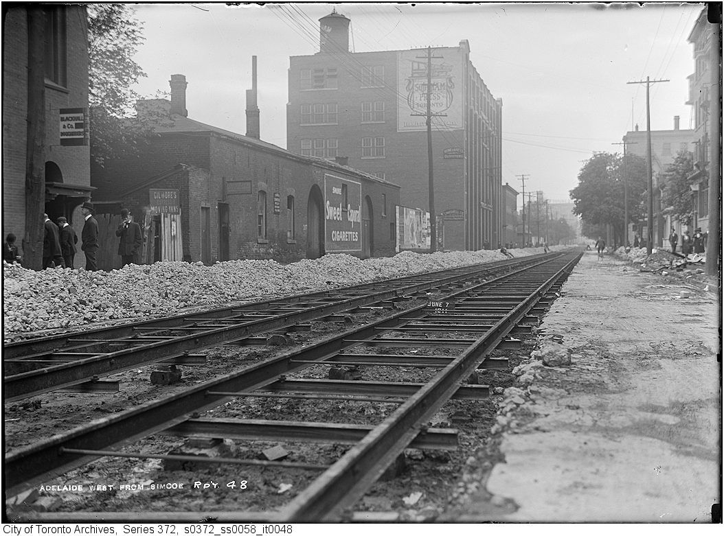
1051.jpg


Now. September 2012.

1052.jpg


In the right distance in the middle of the roadway of the Then picture, a cyclist can be seen. To his approximate right would have been 224 Adelaide W. It's a fast food place now but a tantalizing glimpse of the past can be seen above it.
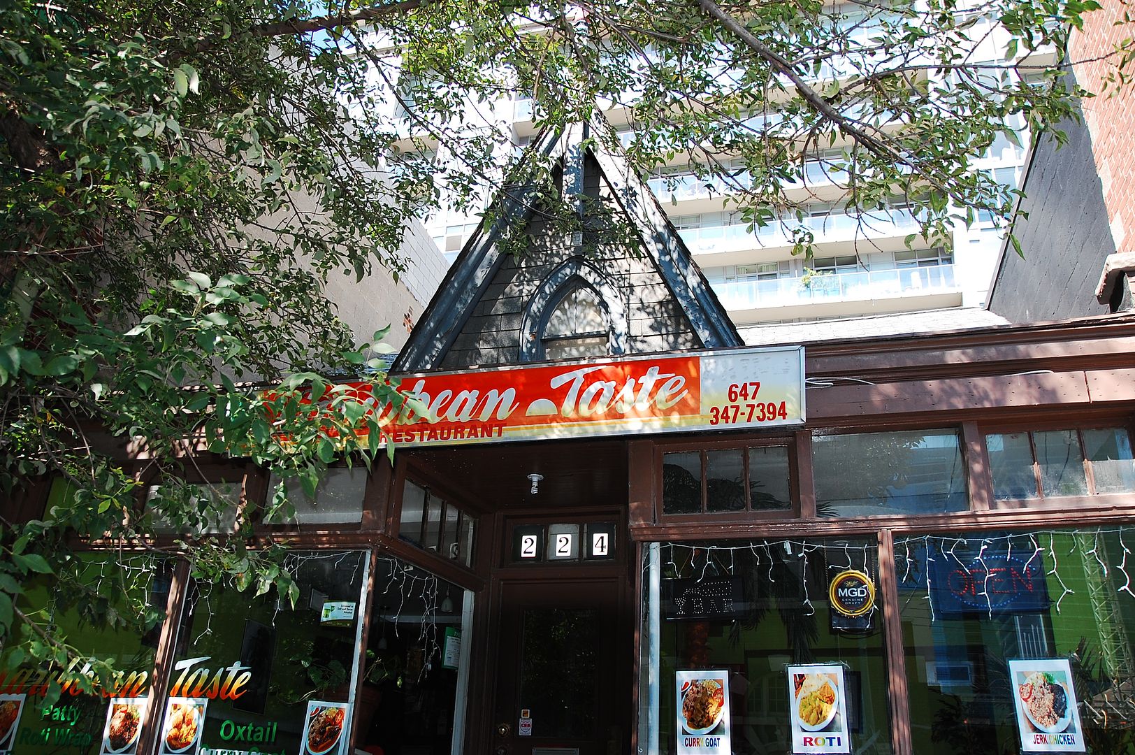

1052a.jpg
 
Last edited:
Then and Now for April 9, 2013.


Then. Adelaide looking W from Simcoe today. Same date as yesterday - June 7, 1911.

There is more 'transportation excitement' today than yesterday - streetcar rails are being laid in this view.

The natty smoking bowler hatted gent is contemplating the beckoning future of railed street transport. Parallel Steel Ribbons; hulking electrified one eyed monsters athwart them, demolishing Time and Space; that is, until you get behind the stop and go mass of cars on Queen westbound from about, oh say, Sorauren, in the evening rush hour. :)

1051.jpg

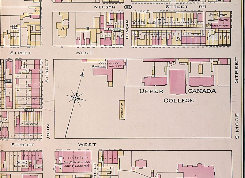
And....the building with the arches in the middle was part of the original Upper Canada College, pictured below looking east in1890:


pictures-r-2330.jpg


20121012-Salvation-UCC-Demo.jpg


1884:

bc6fe4d2-d82e-4874-9fcc-03b92e63d1d9.jpg


f1244_it03001-ucc-king-st-1908-12.jpg


dscn8862.jpg
 

Attachments

  • pictures-r-2330.jpg
    pictures-r-2330.jpg
    95.9 KB · Views: 1,178
  • 20121012-Salvation-UCC-Demo.jpg
    20121012-Salvation-UCC-Demo.jpg
    88.7 KB · Views: 1,282
  • f1244_it03001-ucc-king-st-1908-12.jpg
    f1244_it03001-ucc-king-st-1908-12.jpg
    94.5 KB · Views: 1,135
  • dscn8862.jpg
    dscn8862.jpg
    85.6 KB · Views: 1,084
Last edited:
The first three Drive - in Theatres (1951) within what is now The GTA:

AGINCOURT:
North East, 750 capacity, Park Drive - in Theatres Ltd.

Actually across the border in North York, JT, but the screen was visible from Agincourt :eek:


For Goldie, and other fans of aerial photos:

Aerial Photographs of Valley Lands (Toronto)
Downloadable in jpeg format. The overlays work better in Google Earth.
 
For Goldie, and other fans of aerial photos:

Aerial Photographs of Valley Lands (Toronto)
Downloadable in jpeg format. The overlays work better in Google Earth.

Anna, I must thank you for that wonderful link to 1937/42 aerial photos.

I was pleased to find these images:
1) the site that eventually became the IBM plant (now Celestica) at Don Mills & Eglinton
2) three of the remaining hangars at the old Leaside Airport.

aerial-siteofIBMDonMills193742-frommapsLibraryUofT_zpsdbbc9229.jpg


aerial-3remaininghangarsofLeasideAirport1937_zps17b85596.jpg
 
Anna, I must thank you for that wonderful link to 1937/42 aerial photos.

I was pleased to find these images:
1) the site that eventually became the IBM plant (now Celestica) at Don Mills & Eglinton
2) three of the remaining hangars at the old Leaside Airport.

I was hoping you would find some old abandoned aeroplane parts.:p

pictures-r-3411.jpg
 
Anna, I must thank you for that wonderful link to 1937/42 aerial photos.

I was pleased to find these images:
1) the site that eventually became the IBM plant (now Celestica) at Don Mills & Eglinton
2) three of the remaining hangars at the old Leaside Airport.

aerial-siteofIBMDonMills193742-frommapsLibraryUofT_zpsdbbc9229.jpg


aerial-3remaininghangarsofLeasideAirport1937_zps17b85596.jpg

Goldie, was it serendipity that you posted those two aerial images together? When I was looking for photos of Donlands Farm, I found out that there was an aviation meet there in 1911.

Aviation meet Donlands farm 1911.jpg


The farm was also known as R.J. Fleming's farm. This image looking south on Don Mills Rd is "sometime after 1925."

R.J. Fleming farm ca. 1925.jpg
 

Attachments

  • Aviation meet Donlands farm 1911.jpg
    Aviation meet Donlands farm 1911.jpg
    44.3 KB · Views: 1,283
  • R.J. Fleming farm ca. 1925.jpg
    R.J. Fleming farm ca. 1925.jpg
    47.5 KB · Views: 1,593
Goldie, was it serendipity that you posted those two aerial images together? When I was looking for photos of Donlands Farm, I found out that there was an aviation meet there in 1911.

View attachment 12150

The farm was also known as R.J. Fleming's farm. This image looking south on Don Mills Rd is "sometime after 1925."

View attachment 12151

I've always been confused regarding the location of Donlands Farm.
There was also a Donalda Farm in the same area.

I've seen reports of early air shows at Donlands airfield, Todmorded airfield and Leaside aerodrome.
I wonder if they were all at the same place (Leaside)?

I need a map that will identify those farms.

There was once a farmhouse on Don Mills Rd. - where Wynford is today.
Could that be the one in your last photo?
The road appears to slope-up to the RR crossing that was (still is) there.
 
Last edited:
I think Donlands airfield was simply the fields of Donlands farm, which was east of Don Mills Rd and north of Eglinton (across from the eventual IBM site) and, as you say, south of the RR crossing. According to Sauriol in Remembering the Don, Donlands was owned by the Taylors (the same Taylor family who had mills in the Don Valley at Todmorden and north?) The descriptions with the aviation meet photos on the city archives site mention "Donlands Farm, Todmorden Mills." Leaside airfield was south of Eglinton, at the top of the hill west of Leslie, around where Home Depot is now. I assume that in 1910 or 11, an airfield would be somewhere flat with good updraft (i.e., from the valley).

The only Donalda I know was a farm further north, east of Don Mills, north of Lawrence.
 
Goldie, was it serendipity that you posted those two aerial images together? When I was looking for photos of Donlands Farm, I found out that there was an aviation meet there in 1911.

The farm was also known as R.J. Fleming's farm. This image looking south on Don Mills Rd is "sometime after 1925."

attachment.php

I think Donlands airfield was simply the fields of Donlands farm, which was east of Don Mills Rd and north of Eglinton (across from the eventual IBM site) and, as you say, south of the RR crossing. According to Sauriol in Remembering the Don, Donlands was owned by the Taylors (the same Taylor family who had mills in the Don Valley at Todmorden and north?) The descriptions with the aviation meet photos on the city archives site mention "Donlands Farm, Todmorden Mills." Leaside airfield was south of Eglinton, at the top of the hill west of Leslie, around where Home Depot is now. I assume that in 1910 or 11, an airfield would be somewhere flat with good updraft (i.e., from the valley).

The only Donalda I know was a farm further north, east of Don Mills, north of Lawrence.

I thought that Fleming's farm was south of Eglinton = Flemingdon Park?


Donalda Farm
 

Attachments

  • Flemings:Donlands Farm.jpg
    Flemings:Donlands Farm.jpg
    31.9 KB · Views: 1,180
Last edited:
Yes, probably both sides, since there was no Eglinton Ave there then. And now I get it, that was the barn next to the railway tracks in Goldie's aerial.

Donlands.JPG
 

Attachments

  • Donlands.JPG
    Donlands.JPG
    77.1 KB · Views: 1,140
Yes, I just realized that Eglinton didn't go through. "Until the mid-1950s, Eglinton did not cross either of the valleys of the Don River. The road ended at Laird or Brentcliffe and resumed west of Victoria Park Avenue (then known as Dawes Road)."

Here's one of those fabulous aerials (I'll be up all night looking at them) showing the farm, including the barns south of the tracks, and the barn that's in the other photo (looking east from Don Mills Rd where the OSC is now), on the far right, top. Maybe a horse barn? is the oval a track?

Aerial Donlands Farm.jpg
 

Attachments

  • Aerial Donlands Farm.jpg
    Aerial Donlands Farm.jpg
    65.6 KB · Views: 1,190
Thanks nostalgic and Anna for all that useful info.

I now have a better 'lay-of-the-land' and recall my early days at that very farmhouse.
As a youth, my friends and I often went for hikes up Don Mills Rd. from our homes on Donlands Ave.
That would be during the late 1940s.
I recall that we once stopped at a water pump outside that farmhouse to fill our canteens.
That farm was still there when IBM built across the road in 1951/54.

Donlands2_zpsc5800781.jpg


The same farmhouse facing IBM when it built the northern portion of the plant in 1951. --------- I think I can see the water pump!

IBM1951_zps523cd967.jpg


And the same area in 1966 - looking across Wynford toward the RR bridge over Don Mills Rd.

DonMillsRRunderpassNofEglinton19664_zps76602b7d.jpg
 

Back
Top