News   Nov 22, 2024
 240     1 
News   Nov 22, 2024
 614     4 
News   Nov 22, 2024
 1.6K     5 

Miscellany Toronto Photographs: Then and Now

July 13 addition.


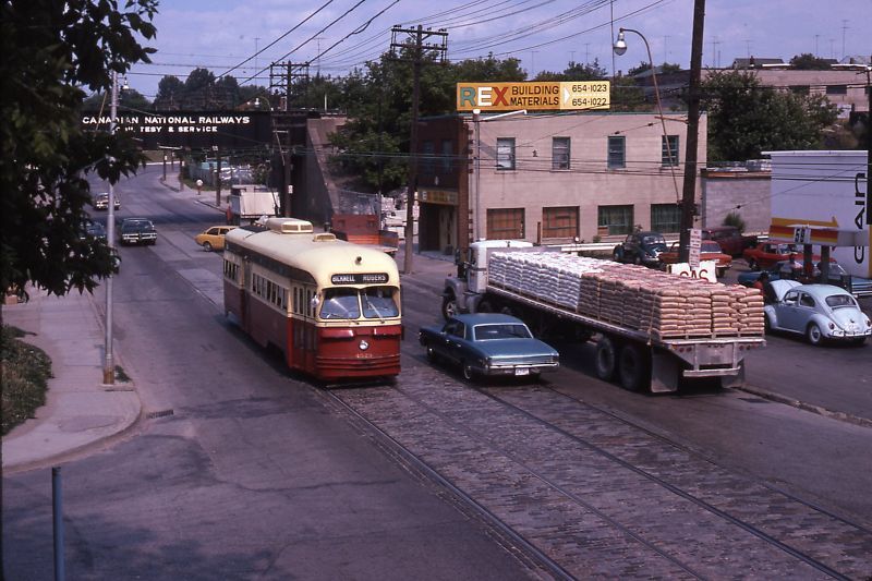
Then. 1974-ish??... Rogers Road at Blackthorne looking E. Picture kindly provided by ValsHere.


851974wonRogersatBlackthorn.jpg


Now. May 2011.


86.jpg

A little earlier, because the trolley bus that replaced the Rogers Rd streetcar started running on July 21, 1974.

Since this is a summer photo, and I don't think they've strung the additional wires for trolley buses, the latest this photo could be is the summer of 1973.
 
I am not sure if you are familiar with the website Transit Toronto http://transit.toronto.on.ca ? It has a plethora of old history and photographs of Toronto centered around Mass Transit. It is not the easiest site to navigate, but there are fantastic essays on the history of transit in Toronto. Many of these discussing urban planning for over the last century and a half. There are so many pages and hidden links that take you to whole other areas and topics. It takes hours just to grasp the size of the database.

I realize the Toronto Archives offers an almost never-ending supply of subjects for the Then and Now thread, but perhaps this site could help with some of the questions of the back-history often arising when an archive picture is posted.

Such a picture would be this great shot looking up Bay Street from Queen's Quay in 1953:

streetcar-4705-58.jpg

(image from Transit Toronto Peter Witts Streetcar section found here: http://transit.toronto.on.ca/streetcar/4501.shtml )
 
One surprising gem I stumbled upon is this alternative history "What If" essay written as if the Queen Street Subway had been built as originally planned. Absolutely fascinating!

Link to essay:
http://transit.toronto.on.ca/streetcar/4016.shtml

Proposed Toronto Queen Street Subway map:
subway-5101-04.gif

(Map courtesy Transit Toronto: Early Subway Proposals found here: http://transit.toronto.on.ca/subway/5101.shtml )

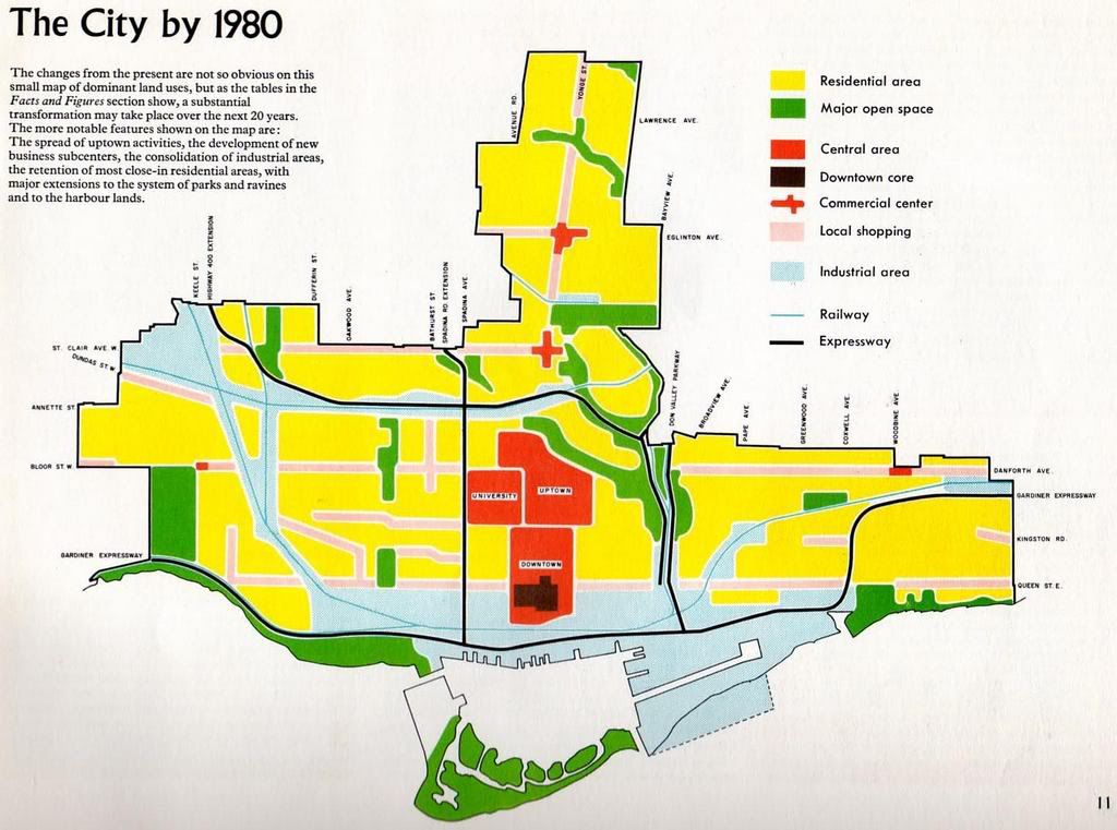
Traynor: Great find. I wonder if one of the reasons the Queen line was never built was the fact that the City at the time saw most of the land south of Queen evolving into a purely industrial district that could not support a subway line. The following map is from a 1959 report produced by the Planning Board called "The Changing City" showing the "future" Toronto in 1980:

2007-09-08-1349-58_edited.jpg


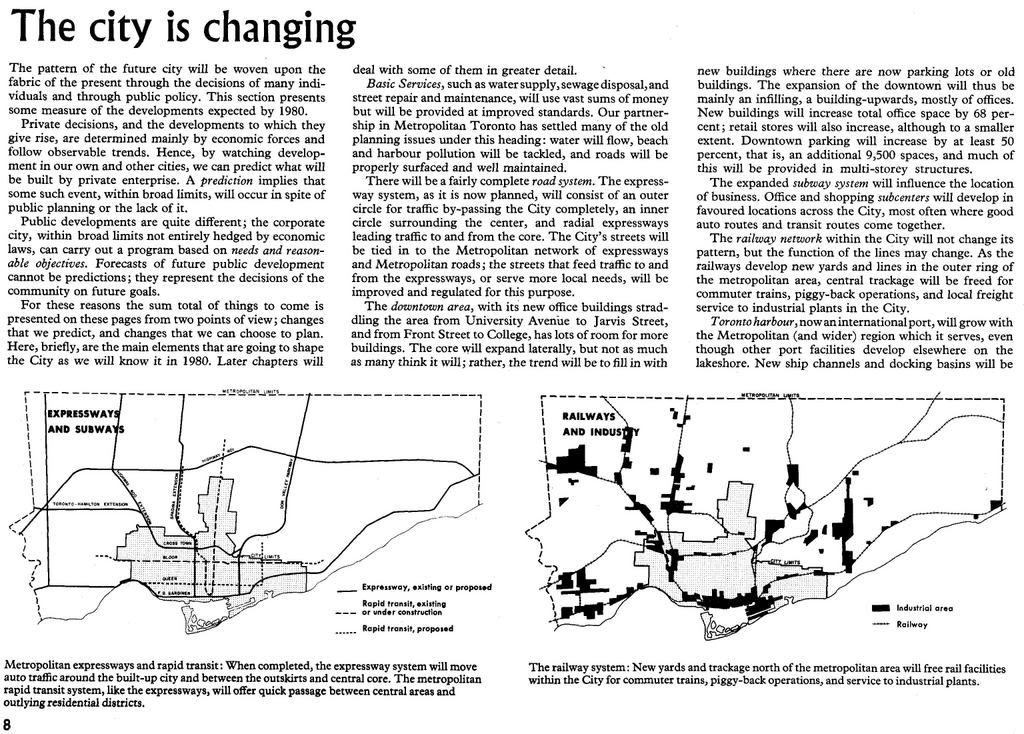
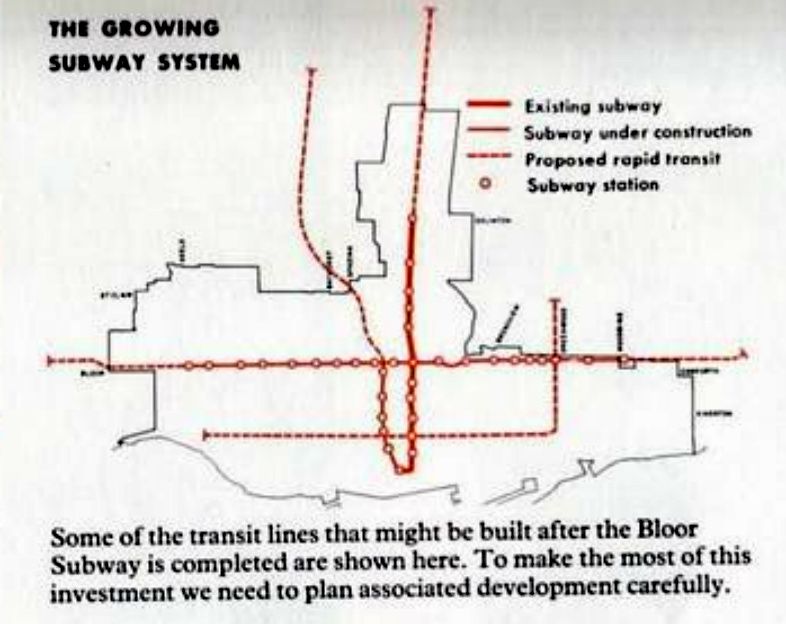
The subway lines show up on this map (along with the proposed expressways):

2007-09-08-1345-18_edited.jpg


2007-09-08-1358-20_edited-1.jpg
 
Last edited:
The reason they went with Bloor instead of Queen is complex and as controversial as any City decision ever is. At the time there were more people, businesses and communities located along the Queen line stretching from the Beach in the East to Mimico and Long Branch in the West, but the Bloor line won out, much to the dismay of business owners in those communities.

One of the deciding factors was the very fortuitous foresight of the designers of the Prince Edward Viaduct.

In terms of crossing the Don Valley, the TTC was fortunate to benefit from the foresight of a designer from the 1910s. Crossing the wide and deep Don Valley would have required an expensive bridge if it weren’t for Edmund Burke (architect) and Thomas Taylor (construction engineer) and their Prince Edward Viaduct. Spurred by the buzz around subway development in 1911, consulting engineers Jacob and Davies recommended to Burke and Thomas that a subway might run along Bloor Street in the future and the viaduct should have a provision for such a line. As a result, Thomas designed into the framework of his Bloor Street Bridge over the Don Valley a lower deck that could be used by subway trains crossing the valley.
(Excerpt from A History of Subways at Transit Toronto found here:
http://transit.toronto.on.ca/subway/5104.shtml )
 
Canary talk: This is from a 2007 posting elsewhere in UT.

Still cookin' at the Canary


www.thestar.com/article/179144

Still cookin' at the Canary

Proud old greasy spoon serves burgers and fries, with a slice of life on the side
Feb 08, 2007 04:30 AM
Bill Taylor
Feature Writer
The Canary roosts at the corner of Front and Cherry Sts. and waits for better times.

Not that life is bad. But the neighbourhood is a bit of a wasteland. It's only a stone's throw from the ritzy Distillery District but in a different world.

Still, the Canary Restaurant is all a-bustle at lunchtime with everyone from construction workers to white-collar LCBO office staff chowing down on basic, honest diner food. You want breakfast for lunch? Not a problem, says waiter Mary Polito. "The only difference is french fries instead of home fries."

The walls are a mix of canary yellow paint, fake brick and real wood. Chrome-backed chairs, Formica tables and a row of stools at the counter. Christmas lights and streamers; Maple Leafs and motorcycle pictures; autographed photos of celebrities; model police cars in the window; hanging planters with artificial plants. It's the sort of place where you go to the cash register to pay and get a genuine "thank you" for your tip. The sort of place where everyone quickly knows your name. Where, whether you're a downtown lawyer or a down-and-out, you'll be treated the same.

"There used to be a flophouse down the street," says Nick Vlahos, who runs the Canary with his brother Tommy. "We'd get them all – hookers, druggies, rubbies. But they were all pretty respectful. We'd help them out, feed them if they were broke. Sometimes you'd get a guy asking for money for food. I'd say, `The food's right here. I'll feed you.' And he'd say, `No, I'd rather have the money.' So you know what he really wants to buy."

"Mom's Special" is in crayon up on a mirror: Three eggs, two strips of bacon, two sausages, ham, a pancake, potatoes, toast and coffee; $8.95. Or perhaps you'd prefer the Vegetarian De-Lite: "One chilled celery stick, seasoned to your taste, along with one carrot stick, washed by hand. Served with a glass of chilled tap water (vintage year). Only $19.95 (seasonal)."

Vlahos put that on the menu "because people used to come in and want vegetarian stuff and get upset when we didn't have it. This is a greasy spoon! I thought, `I'll fix you up ...'"

It's a greasy spoon with a history, relocating from University Ave. and Dundas St. in 1963, with the original Canary sign coming with it. "It's always been in the family," says Vlahos, 48. "I've been working here since I was 13. We're open seven days a week so Tommy and I take alternate days cooking.

"I learned to cook from my dad, except he was very secretive about it. I did a lot of peeking around the corner. This was the industrial heart of the city back then; really thriving. We still get people who remember coming here as kids. We have a great breakfast and lunch business, mostly regulars."

He pauses to fill an order for fries to go, gravy on the side.

"What makes a good short-order cook? Taste-testing everything? Look at the size of me."

The 150-year-old building, with the restaurant as its centrepiece, has a lot of history, too. It first housed a school and then a hotel. Polito swears it's haunted. "There's a sort of vault in the back. I hear whimpering sometimes. The guys say I'm crazy but I know what I hear."

What Vlahos hears is the sound of a new boom in the neighbourhood. "There'll be some highrises going up. Better times are coming."

Next to a giant, plastic Budweiser bottle, a stuffed owl roosts at the end of the Canary's counter and waits.
These indy restaurants aren't threatened, they're extinct. We've lost in the last few months the last two in the downtown core: the City View Cafe in the Simpsons Tower and the Victoria Restaurant at Queen and Victoria. Now I get to sit at McDonalds or Timmys. :(
 
I am not sure if you are familiar with the website Transit Toronto http://transit.toronto.on.ca ? It has a plethora of old history and photographs of Toronto centered around Mass Transit. It is not the easiest site to navigate, but there are fantastic essays on the history of transit in Toronto. Many of these discussing urban planning for over the last century and a half. There are so many pages and hidden links that take you to whole other areas and topics. It takes hours just to grasp the size of the database.

I realize the Toronto Archives offers an almost never-ending supply of subjects for the Then and Now thread, but perhaps this site could help with some of the questions of the back-history often arising when an archive picture is posted.

Such a picture would be this great shot looking up Bay Street from Queen's Quay in 1953:

streetcar-4705-58.jpg

(image from Transit Toronto Peter Witts Streetcar section found here: http://transit.toronto.on.ca/streetcar/4501.shtml )

Quite an amazing resource. I'm surprised by the fact there isn't a forum there.
 
Traynor: Great find. I wonder if one of the reasons the Queen line was never built was the fact that the City at the time saw most of the land south of Queen evolving into a purely industrial district that could not support a subway line. The following map is from a 1959 report produced by the Planning Board called "The Changing City" showing the "future" Toronto in 1980:

2007-09-08-1345-18_edited.jpg

]

''...other port facilities [will] develop elsewhere on the lakeshore..." fascinating how wrong their forecast was about the expansion of Great Lakes freightage - doomed by high speed roads and trucks, air freight, and then, the final nail, the closure of much of the manufacturing (Inglis, Massey Ferguson) on our lakeshore proper.
 
The reason they went with Bloor instead of Queen is complex and as controversial as any City decision ever is. At the time there were more people, businesses and communities located along the Queen line stretching from the Beach in the East to Mimico and Long Branch in the West, but the Bloor line won out, much to the dismay of business owners in those communities.

One of the deciding factors was the very fortuitous foresight of the designers of the Prince Edward Viaduct.


(Excerpt from A History of Subways at Transit Toronto found here:
http://transit.toronto.on.ca/subway/5104.shtml )

This fact never ceases to amaze me. The subway ride across the Don Valley has to be one of the great subway experiences in the world.

I've noticed the subway trains have slowed down quite a bit for the crossing; does anyone know why?
 
Interesting how close Toronto's downtown came to getting butchered by highways ala Detroit. If the subway had been built on Queen we would have lost most of our historic buildings by now. I'm incredibly glad that didn't go through.
 
July 14 addition.


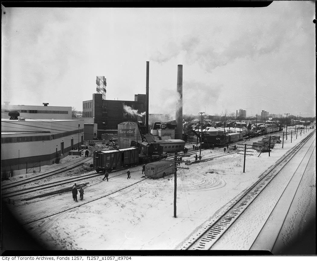
Then. Just for fun. Let's make this thread today a Train Wreck. :) "1.1.1970. Train wreck. Vicinity of Facelle plant Weston."


87TrainwreckvicinityofFacellePlantWeston111970.jpg


Now. April 2011. Sorry about the upper left hand corner; an advertising sign intrudes into the pic and I don't have Photoshop to get rid of it. Would like to get it and learn how to use it... one of my goals in the near future.

Anyways, not many changes over 40 years between the 2 pics. The tissue plant is still there, it's owned by Irving Paper now.

The rail siding is gone, that's nothing new; truck transportation is miles (ha :) ) more flexible and faster than rail ever was.


88.jpg
 

Back
Top