lenaitch
Senior Member
The first couple of pics add perspective to the 'cow catcher' on the front of the streetcar.
There is a really great overhead photo of it in John Bromley's "50 Years of Progressive Transit", from the Toronto Harbour Commission archives. May 1927.You can really sense, from a traveller's level, the temprary Bay St diversion (in order to construct the Union Station viaduct) in the former photo. (I'm more familiar with it from aerial/elevated views.)
So true. Unfortunately, the destruction of the historic core was so gradual, building by building, through demolition by neglect, modernist planning theories, changing tastes that looked at these buildings as "old-fashioned" and a shift of civic energy further north (notwithstanding that the Board of Trade building came down almost simultaneously with the construction of O'Keefe Centre). We could have had our Old Montreal or New York's SoHo if circumstances had been different.One begins to wonder what an incredible historic centre we could've had if that was all preserved, with the new core being built to the south and west (present day Southcore over to CityPlace). Of course pretty much no North American city escaped the mid-20th century unscathed, but the destruction continues today as we somehow accept facadism as preservation.
Yep, definitely a pie-in-the-sky/what-if exercise to imagine what could have been. Always blows me away how our 19th and early 20th century buildings were allowed to rot; that so many people didn't see their value, but that photo progression certainly sums it up.So true. Unfortunately, the destruction of the historic core was so gradual, building by building, through demolition by neglect, modernist planning theories, changing tastes that looked at these buildings as "old-fashioned" and a shift of civic energy further north (notwithstanding that the Board of Trade building came down almost simultaneously with the construction of O'Keefe Centre). We could have had our Old Montreal or New York's SoHo if circumstances had been different.
1900's: Front Street looking west towards Scott Street (the buildings on the right are presently Berczy Park). Note the building on the NE corner of Front and Scott. It is the same building in the next pic.
View attachment 443214
1960's: NE corner of Front and Scott, stripped of all its ornamentation, prior to demolition.
View attachment 443215
1960's: Aerial view.
View attachment 443216
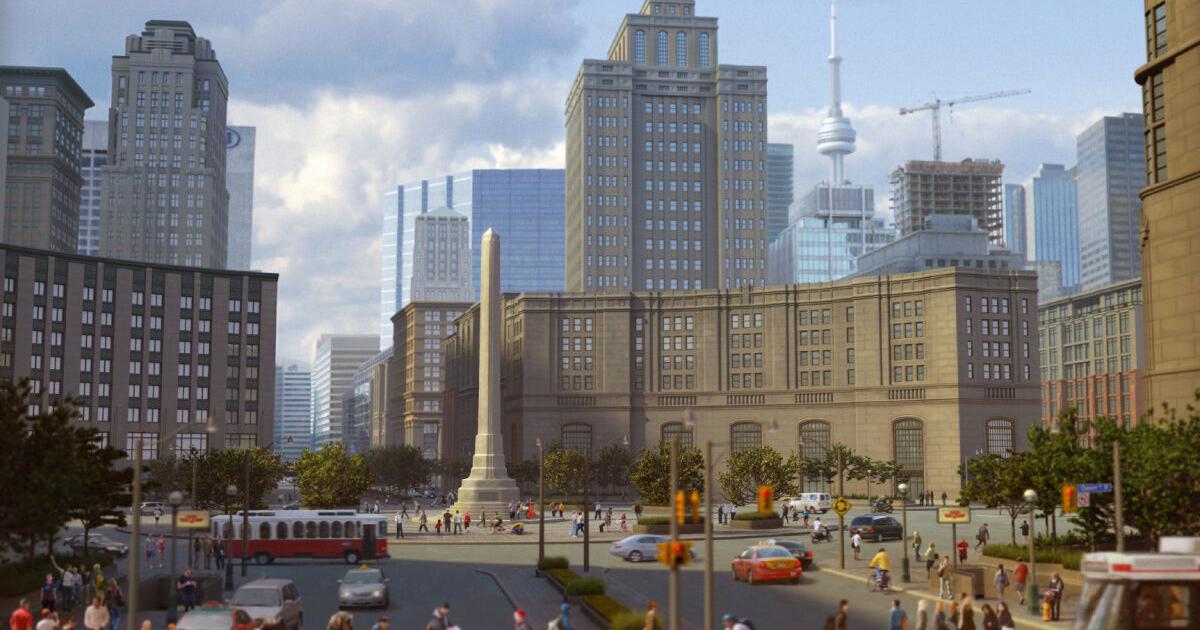
Here's an illustration that was done in 2014 seeing how Vimy Circle would have looked today if it had been built. Though inaccurate in a number of ways, it's a great illustration:Seeing anything related to the University extension just makes me go through the what-ifs for the grand Vimy Circle plans that never came to be.
View attachment 443746
Only thing close that we got was the Canada Life Bldg, which seems to be alluded to in that early illustration.

Ah yes, I came across that article; great visualization indeed. That massive walks and garden plan, and Toronto museum sure would be nice as well.Here's an illustration that was done in 2014 seeing how Vimy Circle would have looked today if it had been built. Though inaccurate in a number of ways, it's a great illustration:
View attachment 443761

The five greatest ideas Toronto never built
From a 1929 scheme to give the downtown a Parisian flair to the first lieutenant governor’s intention to keep the waterfront for the public, here are five ideas that would have changed Toronto.www.thestar.com
One begins to wonder what an incredible historic centre we could've had if that was all preserved, with the new core being built to the south and west (present day Southcore over to CityPlace). Of course pretty much no North American city escaped the mid-20th century unscathed, but the destruction continues today as we somehow accept facadism as preservation.
Alright, let's invent a time machine and make it happen lol. Interestingly that vision would've made Simcoe's Walks and Gardens project more feasible as well; had the waterfront not been resigned to largely industrial uses that 30 acre plan might have been possible.I think the ideal plan in the mid to late 19th century from a metropolitan city-building perspective would have been to preserve the old core and put the railway lines closer to Bloor Street. A new core would have then emerged around the railway corridor on Bloor Street, which would have evolved into the modern skyscraper CBD and kept the old town intact.
The notion of infilling the lake to accommodate the railways and industry south of Front Street downtown would have been rejected in favour of concentrating industry in the Port Lands area (which would have had its own railway connections) and around the railway corridors north of the old core. The preserved old core right at the water's edge on Front Street would have been quite beautiful and valuable (similar to Montreal's Old Town).
But alas, few people in the 19th century envisioned the kind of metropolitan city that would emerge here just 100-150 years later. There was generally no planning done for a city of this size back then in terms of district preservation, future commercial expansion, public spaces, and road allowances.


