News   Apr 16, 2024
 281     0 
News   Apr 16, 2024
 714     3 
News   Apr 16, 2024
 485     3 

Lost Road: Indian Line Road

I remember crossing the bridge by the dam - back in the day it was a single lane with a set of lights to alternate between allowing northbound and southbound traffic to cross.

I also remember swimming in the reservoir in the days before Wild Water Kingdom came along. And fishing at the base of the dam.

Wow, that must have been something. As for me, I'm trying to remember if I ever actually travelled up Indian Line from the 427 before the highway was extended. I think I did but I'm not sure. I remember at Christmas time, 1981, we were taking the 401 to visit relatives and my dad took us up that huge ramp to the 427 northbound... it must have been by accident because the 427 really didn't go anywhere at the time. I remember being awed and a little frightened by the height of the ramp, and that Trouble by Lindsey Buckingham was playing on the radio. Kind of a singular moment. What we did after that — get off at Airport Road, Finch, or go all the way to Albion — I can't recall.

I remember too that I had a buddy who used to like to just get out and drive around on the weekends just for the hell of it and to listen to music. We did a lot of exploring and we had a friend in Malton, so I distinctly remember the light at Morningstar Drive where we used to turn left across southbound 427 traffic. That still amazes me. But if we ever made it to the Indian Line bridge and exit, I don't recall.
 
There was also another light a few km's south of Morning Star at the 409 where southbound travellers would have to cross northbound traffic to get on the 409.

I've heard about that. I must have seen it but I can't remember it.
 
What is this supposed to be? It just brings me to a view of the centre of Mississauga.

Hmm, yeah, me too... bird's eye view of North America's ugliest city hall. :)
 
I remember crossing the bridge by the dam - back in the day it was a single lane with a set of lights to alternate between allowing northbound and southbound traffic to cross.

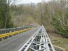
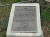
i read this thread with great interest having driven indian line alot and noticed that no one mentioned the single lane bridge over the humber river below the dam was a bailey bridge installed by the army engineers after hurricane hazel washed out the previous bridge in 1954. it was there until the mid 1980's. there were several bailey bridges installed at the same time in different locations and at least one still exists. take finch avenue e. west from sewels road. on the south/west side of the bridge is a plaque.
 

Attachments

  • IMG_2086.jpg
    IMG_2086.jpg
    97.6 KB · Views: 495
  • IMG_2088.jpg
    IMG_2088.jpg
    97.9 KB · Views: 476
Another extant Bailey bridge w/heritage status is the ped footbridge across the Lakeshore at the CNE, S of the windmill/Scadding Cabin.

Also, the one next Don Mills south of Overlea...
 
Another extant Bailey bridge w/heritage status is the ped footbridge across the Lakeshore at the CNE, S of the windmill/Scadding Cabin.

Also, the one next Don Mills south of Overlea...

thanks for the heads up adma. both of those are relegated to pedestrian traffic, you can still drive over the finch avenue bridge.
 
Kirkhams Road is blocked off as a result of that big August rainstorm a few years back. The bridge needs repairs but probably won't ever get them because there would be no justification for the cost.

Turns out they're intending to pull it down... deck, abutments, piers and all. I was out there recently and nature's done an impressive job of splitting the concrete and forcing new life through it in just five years.
 
Hey all. Thanks for the sweet memories, though you don't know me I was touched by your thread. Funny that I came across this when I was hoping to track my old home which was on Indan Line! I see these posts are old but thought I would write. I used to live on a farm on Indian Line, I guess north of where Morningstar Drive would be (if it reached Indian Line at the time). I lived on the farm at Humber River Eqestrians and next door there was another family home, then the Circle C Ranch. I used to swim with my horse in the river. If anyone reads this, I wonder if I might ask: could I possibly find the land my old home stood on, or even get near that part of the river which was south of the dam? I spent a lot of time walking Indian Line as a kid both ways, towards 50, Steeles and the other way back towards Malton. Thanks for the memories in any case.
 

Back
Top