News   Jan 03, 2025
 1.4K     1 
News   Jan 03, 2025
 1.5K     0 
News   Jan 03, 2025
 2.1K     0 

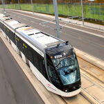
King Street (Streetcar Transit Priority)

On another point - one other issue with the pilot and with all "lets put out some planters" temporary schemes is GPS. Look at how that Uber blundered into the York ramp demolition - probably following GPS rather than paying attention to surroundings.

With older generation SD card systems relying on manual updates, I suspect much more of the same during the pilot.
This is a good point. It always frustrates me when drivers (probably tourists) try to make illegal left and right turns at Yonge/Shuter into the Eaton Centre. But I just realized that if I ask Google for driving directions to the Eaton Centre, it directs me down Yonge. I can't really blame them since it would be hard to figure out how to get onto Shuter to get into the Eaton Centre legally.
 
95% of people follow the rules here.

lol really? Almost every time I look out my window onto the Bloor-Yonge intersection, I see people not obeying the turn restrictions or running a red light.

Yes, really. If you see someone doing this every 10 minutes, that's still less than 0.5% of the traffic at Yonge & Bloor. Even in the 404 carpool lanes that I take every day, 9/10 cars are actually carpooling (or electric).

They can't install curbs because the streetcars still have to go through.

Curb lane only...?
 
Yes, really. 1 in 20, 1 in 50, even 1 in 100 (99%) seems like a lot more than it is. Even in the 404 carpool lanes that I take every day, 9/10 cars are actually carpooling (or electric)


Curb lane only...?
Ok, well even if only 1 in 20 don't follow the rules, that one person ends up creating a traffic mess for everyone else (which is probably why it seems like a lot more than it is).
 
95% of people follow the rules here
Not where I live. We regularly have a "no standing" area that is packed full of parked cars making the road impassable at times. Not to mention rolling stops, red light running (my daughter got t-boned by a red light runner the other day), illegal left turns, and I could go on.
 
lol really? Almost every time I look out my window onto the Bloor-Yonge intersection, I see people not obeying the turn restrictions or running a red light.
breaking/stretching rules is not unique to car drivers.....look at any controlled intersection at any light cycle at any point in the day and you will find pedestrians entering the intersection after the countdown begins (often long after)....this will only make King worse as car drivers get frustrated over a bunch of forced right turns that are impossible to make due to pedestrian flows....it is unworkable in our current situation.
 
breaking/stretching rules is not unique to car drivers.....look at any controlled intersection at any light cycle at any point in the day and you will find pedestrians entering the intersection after the countdown begins (often long after)....this will only make King worse as car drivers get frustrated over a bunch of forced right turns that are impossible to make due to pedestrian flows....it is unworkable in our current situation.
That's not quite comparable. And some of the lights are white for about 3 seconds, and then start counting down in the 20s ... and are still in the teens when you finish crossing. What do you think people will do?

It's very workable. It will be a nightmare for cars, and they'll know to stay away. Problem solved. Okay, I'm being flippant, but it's all about travel time - if it becomes very slow, then you don't drive that way. Which is why you don't see traffic jams on Colborne Street - because it doesn't get you anywhere; how is King going to be any different, other than name recognition?
 
This sounds like a convoluted mess by a City Hall that says "pedestrians and transit comes first" but forgets to mention that added onto that is "as long as it doesn't inconvenience drivers". Let the far left/right lanes operate anyway they want but just paint the middle lanes green for streetcar use only and be done with it.

This looks like the classic notion of trying to accommodate everyone and in return servicing no one.
Cities where built for people, not cars and time to get back to it using transit that can carry more people per hour than a car and remove the car from various corridors. Paris who is killing cars off and setting up zoning areas for deliveries, Toronto can do the same thing. Paris is not the only city doing this. At best, 20,000 cars = 25,000 riders vs. 65,000 transit riders.
 
That's not quite comparable. And some of the lights are white for about 3 seconds, and then start counting down in the 20s ... and are still in the teens when you finish crossing. What do you think people will do?

It's very workable. It will be a nightmare for cars, and they'll know to stay away. Problem solved. Okay, I'm being flippant, but it's all about travel time - if it becomes very slow, then you don't drive that way. Which is why you don't see traffic jams on Colborne Street - because it doesn't get you anywhere; how is King going to be any different, other than name recognition?
I really was just following on in the discussion if this is workable....it led to a discussion about cars breaking rules and then I pointed out cars are not the only ones that do.

I think having cars forced off of King via right turns sounds like a good idea....but if they end up never being able to get off of King via those right turns because the pedestrian blockage a couple of things could happen....1) you are right they may just avoid King altogether (but I have to ask if this is the goal why not just do it...instead of half assing it) or 2) they will find a way to "break the rules" (like you said in response to my pedestrian point....if the setup is unreasonable "what do you think people will do?") and perhaps find a way to stay on King and get in the way of the streetcars......it will all come down to enforcement....of some rule or another.
 
Cities where built for people, not cars and time to get back to it using transit that can carry more people per hour than a car and remove the car from various corridors. Paris who is killing cars off and setting up zoning areas for deliveries, Toronto can do the same thing. Paris is not the only city doing this. At best, 20,000 cars = 25,000 riders vs. 65,000 transit riders.
12 major cities that are starting to go car-free

Business Insider
Leanna Garfield
Feb. 2, 2017, 11:34 AM

In late 2016, Madrid's Mayor Manuela Carmena reiterated her plan to kick personal cars out of the city center.

On Spanish radio network Cadena Ser, she confirmed that Madrid's main avenue, the Gran Vía, will only allow access to bikes, buses, and taxis before she leaves office in May 2019. It's part of a larger effort to ban all diesel cars in Madrid by 2025.

But the Spanish city is not the only one getting ready to take the car-free plunge. Urban planners and policy makers around the world have started to brainstorm ways that cities can create more space for pedestrians and lower CO2 emissions from diesel.

Here are 12 cities leading the car-free movement: [...]
http://www.businessinsider.com/citi...#madrids-planned-ban-is-even-more-extensive-2

Vancouver is in the list. Toronto is so yesterday, and not in a good way...
 
Vancouver is doing a lot of things right but I don't know why it made the list. All those other cities listed are in some ways getting rid of cars by tolls or greatly limiting use and Vancouver has not been doing that but rather just taking a lane away on a few streets for bikes. A good step but not comparable to cities looking to ban cars. Point of fact Calgary does better in this regard than Vancouver. Calgary has a larger bike system and has two streets that cross the entire city that are mostly closed to traffic for their entire lengths............ the CTrain/transit-only route and the completely carless Stephen Avenue Mall.
 
Vancouver is doing a lot of things right but I don't know why it made the list.
Maybe accessing the link and reading might give you clue?
As Citylab notes, people in Vancouver take half of all trips by foot, bike, bus, or subway as of 2015. This is considerably more than any US city of comparable size, including Seattle (21%) and Philadelphia (27%), according to a 2015 United Nations report.

The city's car-free movement might have been spawned by urban design decisions, according to the nonprofit Streetfilms, which recently interviewed key planning officials. Efforts include turning part of a major avenue, called Granville Street, into a pedestrian mall in the 1970s and expanding the bike lane network in 2008.

The city also hosts a car-free day every June, when it bans cars from busy blocks and sets up a street festivals.
And if you clicked on the the third word in the quoted text above, you'd realize:
When it comes to nudging drivers out of cars, Vancouver ranks as North America’s biggest success story. Fully 10 percent of commutes to work are on bikes, far exceeding U.S. and Canadian cities of a comparable size. As of 2015, half of all trips within city limits are taken on foot, bike, or transit—a goal the city had hoped to reach by 2020. Ahead of schedule—and way ahead of its peers on this continent—Vancouver’s “active transit” success is the subject of a new short documentary by STREETFILMS. In interviews with key planning officials and advocates in attendance at a summer 2016 placemaking conference, filmmaker Clarence Eckerson traces the city’s remarkable urban trajectory and shows how Vancouver managed to avoid the planning pitfalls that claimed so many other towns over the past few decades.

It all began back in the late 1960s, says the city’s former chief planner (and urban-Twitter celeb) Brent Toderian, when residents rejected a proposed highway that would have torn up the dense urban core and separated it from its famous waterfront. Vancouver is still the only major North American city without a freeway running through it. The open waterfront became the location of the hugely successful Expo ‘86, which was themed around the future of transportation and featured the debut of the elevated SkyTrain, a swoopy automated light rail system. A new extension that opened in December allowed SkyTrain to reclaim its title as the world’s longest fully automated metro system in the world (besting the similarly driverless Dubai Metro). The system also helped pave the way for the dramatic transformation of Vancouver’s waterfront a couple of years later. Hundreds of new residences and offices were built, unified by pedestrian thoroughfares and the city’s seawall—which is “routinely ranked as the best public space in at least Canada,” says Toderian.

The 2010 Winter Olympics encouraged more car-to-pedestrian street conversations, and peppering the in-between years were lots of smart decision-making, such as turning a stretch of Granville Street into a pedestrian mall in the 1970s and the city’s 2008 strategic shift to support cycling as daily form of mobility rather than pure recreation. A mess of new protected bike lanes have pushed Vancouver’s active-transit infrastructure beyond the downtown core: “24 percent of our bike network is now considered [appropriate] for all ages and abilities,” says Dale Bracewell, the city’s manager of transportation planning. A $2 billion plan to expand TransLink, Vancouver’s mass transportation network, was approved last month by the mayor’s council, and stands to bring active transit options to parts of the city that haven’t had them before.

“As a user … I’ve got choices. And the best thing is not just to have available choices but delightful choices, every day,” says Toderian. “That’s been built up over decades—generations of city-making that are really now coming together.”
https://www.citylab.com/transportat...car-free-capital/509480/?utm_source=SFTwitter

You can lead a fool to water, but you can't make them think...
 
Last edited:
Vancouver is doing a lot of things right but I don't know why it made the list. All those other cities listed are in some ways getting rid of cars by tolls or greatly limiting use and Vancouver has not been doing that but rather just taking a lane away on a few streets for bikes. A good step but not comparable to cities looking to ban cars. Point of fact Calgary does better in this regard than Vancouver. Calgary has a larger bike system and has two streets that cross the entire city that are mostly closed to traffic for their entire lengths............ the CTrain/transit-only route and the completely carless Stephen Avenue Mall.
In terms of transit....

I disagree with Calgary's transit system. The 7th avenue transit mall is so yesterday. It's not something they are proud of. The trains are packed with plenty of red lights at every block. It can take 15-20 minutes to get past the core. Calgary's transit network sucks if you don't live near a C-Train station. They don't have any rail to the airport. Their bus network is setup to feed the C-Trains. If it breaks down, the entire quarter of the city's transit is screwed. They don't have any parallel bus service unlike here in TO we have a proper grid system. There bus routes go in loops. The city limit is as big as TO rotated vertically. To get from the north end to south end is like Etobicoke to Scarborough. Oh yeah, their service disruption announcements go on for hours after it cleared. Talk about backwards. No, they don't have a smart card system either. TTC is way better in terms of servicing the entire city and not being stuck on packed trains dwelling 30 seconds at every downtown stop in rush hour. Yes people do get left behind.

Vancouver is better off than Calgary. I'm not so impress with their skytrain capacity. It's packed within years of opening. They miscalculated their ridership and would need a major expensive overhaul at every station to support longer trains. They are also very proud that the newly opened Evergreen Line has 30,000 daily ridership while we call the 50,000 ridership Sheppard subway a white elephant. They did manage to separate the Expo line from the Millennium Line allowing trains to run closer together. Personally I think Vancouver is just wasting money on this so called Skytrain proprietary technology. They could have invested in a heavy rail with wider cars. The SkyTrains could only carries half the capacity of the Yonge line. Their zone system makes it more expensive to travel the same distance vs. Toronto or Calgary. At least they have affordable rapid transit to the airport unlike the pricey UPX that doesn't connect to the TTC. Vancouver's bike network works better cause their city is more dense than Toronto, Montreal or Calgary. They also invested years before TO.

There are things Toronto did right that Calgary and Vancouver isn't doing right. Simple stuff like a good overnight network and a 10-min max surface network are unheard of in Vancouver or Calgary. Only Montreal has a comparable network. TTC has a higher farebox ratio. Vancouver is just giving themselves a pat on the back while their lines carry far less riders than the TTC. Every city has it's own problem.
 
When it comes to nudging drivers out of cars, Vancouver ranks as North America’s biggest success story. Fully 10 percent of commutes to work are on bikes, far exceeding U.S. and Canadian cities of a comparable size. As of 2015, half of all trips within city limits are taken on foot, bike, or transit—a goal the city had hoped to reach by 2020.

That's the City of Vancouver. Not the Vancouver CMA or Metro Vancouver.

In the 2011 census, 46% of Toronto's employed population walked, biked or took public transit to work, and another 4.5% were a passenger in a carpool. Vancouver had statistically identical numbers - 46.8% and 3.6%. When you consider that Richmond, Burnaby and North Vancouver all have much lower percentages, Toronto is way ahead.

Look at the CMAs too - Toronto has 23.3% of commutes on public transit, 4.5% walking, 1.2% biking and 5.4% as passengers in a carpool. Vancouver has 19.7%, 6.2%, 1.8% and 4.9%. Definitely not any better than Toronto.
 
SteveX.............you talk of SkyTrain's low capacity and stating they should get rid of the proprietary technology {which it's not BTW} and switch to higher capacity standard 3rd rail. Well the line with, by far, the lowest capacity is the Canada Line which IS 3rd rail. The technology has nothing to do with capacity, it's 2 things...........frequency availability and station size. The Canada Line stations are puny at 40 meters and can only be extended to 50 meters. The ART SkyTrain stations on the other hand are all 75 meters and can be extended to 100 meters.

As for CTrain transit mall in downtown Calgary being "so yesterday" is NOT the point. The point was that Calgary was willing to cut off an entire road thru the downtown from cars to give transit 100% priority backed up with the pedestrian-only Stephen Avenue Mall. The article was about cities reclaiming their downtown streets for transit and pedestrians and technically Calgary has done more in that regard than any city in the country.

Also if CTrain's downtown transit-only route is "so yesterday" then god help what you think of Toronto's "bold" intiative of King Street to hurry along the streetcars and still not even getting streetcar-only lanes little alone and entire downtown road strictly for transit.
 

Back
Top