News   Jul 03, 2024
 130     0 
News   Jul 02, 2024
 876     0 
News   Jul 02, 2024
 2.4K     0 

GO Transit: Construction Projects (Metrolinx, various)

It is worth noting that building of the bridge will happen concurrently with the demolition of Market Village and construction of Remington Centre. It will be interesting to see how Steeles traffic turns out.
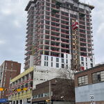
Remington Centre? Is that actually starting construction after all these years? :D
 
Stouffville Line double tracking update Thursday 18 January 2018:

Milliken Station looking north: I saw many people deliberately walk in front of moving GO trains while the lights were flashing. And even worse, they also walked directly behind the train while the lights were still flashing, which is a recipe for getting hit by a second train coming the other way. The low train speeds seem to give people a sense of safety, which is also presumably why people keep getting hit by streetcars.
38887364945_5b77912181_b.jpg

Even though it will be replaced soon I think the various cities in the GTA have horrible pedestrian warnings at crossings. The best that I have seen are actual arms that lower specifically for pedestrians/bikes. And they put fencing on either side so no one can squeeze around it.

At a minimum there should be bollards with warning signs so at least you have to make a conscious effort to get around them.

Adding the pedestrian arms are not difficult. And with the supposed zero-fatality goal for pedestrians it is something 100% in the City's control.
 
And with the supposed zero-fatality goal for pedestrians it is something 100% in the City's control.
Thumbs up for Reaper's original point and thumbs up for yours for the gist, but technically, it's completely in a domain the province administrates, but the Feds regulate, but cities are expected to contribute costs to.

Must run right now, but will quote from the Railway Crossings and Safety Acts later. Many sections of the Signals and Crossings Act (sic) call for shared costs.

Reaper's mention of "streetcars" in very relevant for the King Pilot Project, especially if/when speeds increase even further (my feeling is that they should, but pedestrian safety might/must require fencing, at least in sections near stations. Melbourne has had to seriously address this issue.
 
Its the railways that control the signals I believe. I remember an issue in Sudbury where a busy road that was used by trucks coming and going from mines only had bells and lights, but no crossing arm. The city for years asked for CN to install gates but CN would not budge until a couple years ago when the extension (which is expressway-ish with roundabouts and two interchanges) was approved. Phase 2 will see the road go over the tracks.
 
I mentioned this in the Metrolinx (Catch All) thread but there are several GO Construction-related projects so thought I'd post this here as well.

Looks like Metrolinx has created a specific "Projects Page" that's linked to from their homepage. Check it out here.
 
I mentioned this in the Metrolinx (Catch All) thread but there are several GO Construction-related projects so thought I'd post this here as well.

Looks like Metrolinx has created a specific "Projects Page" that's linked to from their homepage. Check it out here.

Some interesting notes here:

Milton: Either there are or will be 30% more trips, unclear as to which.

Kitchener: Breslau is now marked as a potential future station
kitchener-map.jpg


It also says various improvements on Kitchener and Lakeshore East have made or will make travel 20% shorter, also unclear as to which. Don't see similar claims on the other pages.
 
I mentioned this in the Metrolinx (Catch All) thread but there are several GO Construction-related projects so thought I'd post this here as well.

Looks like Metrolinx has created a specific "Projects Page" that's linked to from their homepage. Check it out here.

Much better organized than before, but still some projects have more detail than others. The same level of detail should be included for every project. Eg - no link to the Niagara EA documentation. And where's Bowmanville?

- Paul
 
Much better organized than before, but still some projects have more detail than others. The same level of detail should be included for every project. Eg - no link to the Niagara EA documentation. And where's Bowmanville?
I like the new style; easier for the average resident to browser.
I've sent an email to Anne Marie Aikens about the deficiencies.

There is REALLY nice "Projects" list for the Barrie line:
http://www.metrolinx.com/en/greaterregion/projects/barrie-go-expansion.aspx

But BLANK "Projects" the Lakeshore West line which is not true.
http://www.metrolinx.com/en/greaterregion/projects/lakeshorewest-go-expansion.aspx

I have seen dozens of links to Metrolinx documents of many ongoing projects along Lakeshore West, so hopefully they'll fill-in soon with missing links to existing documents. Information gotta be complete.

They probably had a publishing deadline and their web designer probably didn't have all the links, hopefully they expedite filling in the missing links.
 
Last edited:
Here's brand new Metrolinx images of each region:

upload_2018-1-24_20-4-32.png

Observation: DRL omitted -- it's post-2025 completion date


upload_2018-1-24_20-6-33.png


upload_2018-1-24_20-6-54.png


upload_2018-1-24_20-7-17.png


upload_2018-1-24_20-7-37.png


upload_2018-1-24_20-8-19.png


upload_2018-1-24_20-8-43.png


upload_2018-1-24_20-9-23.png


upload_2018-1-24_20-10-31.png
 

Attachments

  • upload_2018-1-24_20-4-32.png
    upload_2018-1-24_20-4-32.png
    1.1 MB · Views: 534
  • upload_2018-1-24_20-6-33.png
    upload_2018-1-24_20-6-33.png
    477.8 KB · Views: 350
  • upload_2018-1-24_20-6-54.png
    upload_2018-1-24_20-6-54.png
    1.4 MB · Views: 347
  • upload_2018-1-24_20-7-17.png
    upload_2018-1-24_20-7-17.png
    1.2 MB · Views: 403
  • upload_2018-1-24_20-7-37.png
    upload_2018-1-24_20-7-37.png
    806.4 KB · Views: 435
  • upload_2018-1-24_20-8-19.png
    upload_2018-1-24_20-8-19.png
    740.3 KB · Views: 352
  • upload_2018-1-24_20-8-43.png
    upload_2018-1-24_20-8-43.png
    586.1 KB · Views: 341
  • upload_2018-1-24_20-9-23.png
    upload_2018-1-24_20-9-23.png
    772.6 KB · Views: 329
  • upload_2018-1-24_20-10-31.png
    upload_2018-1-24_20-10-31.png
    168 KB · Views: 360
Most people here will know that the York map has a pretty big error: it shows the rapidway as continuing on Highway 7 rather than going down Bathurst and across Centre, which means that the Keele, Dufferin, Promenade, and Atkinson stops are all in the wrong location. The "Dufferin" stop on the map is where the Bathurst stop (currently under construction) actually is.
 
Poor Brampton, all they're going to see in the next 10 years is 3 LRT stations that just kiss their southern border. At least they've invested in their bus system to somewhat makeup for that fact.

Milton is another sad case in those maps.
 

Back
Top