|
|
|


You are using an out of date browser. It may not display this or other websites correctly.
You should upgrade or use an alternative browser.
You should upgrade or use an alternative browser.
Evocative Images of Lost Toronto
- Thread starter LowPolygon
- Start date

Ramako
Moderator
Does anyone have old pictures of 83 Yonge Street from the past? Potbelly Sandwich Shop is moving into the retail space.
Goldie
Senior Member
This is Waterloo, Ont., but still quite interesting, I thought.
A corduroy road is revealed in recent excavations.
Additional info at these CBC sites:
http://www.cbc.ca/beta/news/canada/...ng-street-in-waterloo-to-be-removed-1.3545309
http://www.cbc.ca/beta/news/canada/...-found-king-street-lrt-construction-1.3502375

A corduroy road is revealed in recent excavations.
Additional info at these CBC sites:
http://www.cbc.ca/beta/news/canada/...ng-street-in-waterloo-to-be-removed-1.3545309
http://www.cbc.ca/beta/news/canada/...-found-king-street-lrt-construction-1.3502375
Attachments

Last edited:
sonny
New Member
Read a lot about the 1929 > depression , absolutely heart breaking story's , and man's inhumanity to his fellow man,Most of these kids would be long gone by now, i just hope that the remainder of their lives were a little bit kinder.Students at Danforth Park Public School in 1935 - during the "Great Depression."
There's are unique lessons to be learned by anyone interested enough to research these sad times.
View attachment 73248
wolfewood
Active Member
^Definitely. One of my favourite books in undergrad was Katrina Srigley's Breadwinning Daughters, about women during the Depression. There's some great stories in there, including my favourite about a middle class woman attending U of T during the Depression. She tried to attend a physics class, only to find the professor and his male students had barricaded the door. The men then went on to scream, "Go away you little Victoria angels! Go back to Vic and enroll in the Household Economics course! We don't want you in math and physics!" Not quite what @Goldie was thinking of but its an absurd and amusing story that reminds me of how far we've come since then, not just economically.
Goldie
Senior Member

AlbertHWagstaff
Senior Member
Of transit interest this was just about the end for the old Can-Car Brill trolleys as the refurbishing and re-bodying program was getting close to finishing which is probably why the photographer was chasing it.
Attachments

Last edited:
gimbal
New Member
I think your friend is correct. It looks like Mt. Pleasant Rd (Northbound) at Dinnick Cres.
https://goo.gl/maps/Emh29cdhBDv
https://goo.gl/maps/Emh29cdhBDv
nostalgic
Active Member
View attachment 82025 Ok sleuths, this one has stumped me and a friend who checked the former trolley coach routes. Four lane street with grassy boulevards and substantial houses. I thought Annette around High Park but no. My friend thought Mt. Pleasant but couldn't place it. The scene is from January 1972 and the photographer also took shots along the Ossington route that day. No prize for this but I'd certainly appreciate any help with placing it. The side street has a NO HEAVY TRUCKS sign and that's the only signage visible in the pic. I figured the sharp eyes and memories in this forum would be able to locate it if anyone could. Thanks!
Of transit interest this was just about the end for the old Can-Car Brill trolleys as the refurbishing and re-bodying program was getting close to finishing which is probably why the photographer was chasing it.
I’m pretty sure it’s Mt. Pleasant Rd. looking north at Dinnick Cres.
AlbertHWagstaff
Senior Member
I’m pretty sure it’s Mt. Pleasant Rd. looking north at Dinnick Cres.
Thanks! That's it.
AlbertHWagstaff
Senior Member

AlbertHWagstaff
Senior Member
With the heat and humidity going strong, here's something to cool things down: the great storm of 1944. Not sure where this is although I have a couple of other pictures from the College & Bay area so I'm guessing it's further west on College St with the three-storey commercial buildings. If anyone can place it, please do.
Attachments

Goldie
Senior Member
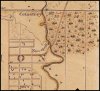
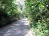
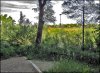
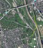
I've always been intrigued by the street (Winchester) that comes to an abrupt end at the Riverdale Farm (formerly the Toronto Zoo). The street once curved to the north as it went downhill into the Don Valley, crossing two rail lines and the Don River. It went N/E to meet Danforth at Broadview. The last few yards of Winchester, before it ended at Danforth, is now a northbound entrance to the Don Valley Parkway (Now named: Royal Dr.). Winchester St. was closed when the the Bayview Extension and DVP were given rights-of-way thru the valley.
The original route of Winchester is seen on maps as early as 1851.

Here is the road as it curved down into the valley alongside the Zoo.

And this is the same area today (closed and overgrown) as it abruptly ends at the Bayview Extension (photos thanks to Rudy (r937) and his exploratory talents).


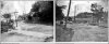
This is where the Bayview road is today - built upon an old belt-line right-of-way (photos c.1900).

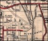
Map - 1916

Aerial today (thanks to Google)

Winchester Bridge over the Don River in 1909 and 1915.
1909

1915

The original route of Winchester is seen on maps as early as 1851.
Here is the road as it curved down into the valley alongside the Zoo.
And this is the same area today (closed and overgrown) as it abruptly ends at the Bayview Extension (photos thanks to Rudy (r937) and his exploratory talents).
This is where the Bayview road is today - built upon an old belt-line right-of-way (photos c.1900).
Map - 1916
Aerial today (thanks to Google)
Winchester Bridge over the Don River in 1909 and 1915.
1909
1915
Attachments
-
 map 1851.jpg139.6 KB · Views: 1,149
 -
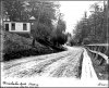 Winchester at zoo 1907.jpg627.6 KB · Views: 1,173
 -
 winchester-street-looking-east by r937.jpg271.4 KB · Views: 1,137
 -
 Winchester Dr. -end- by Rudy Limeback.jpg391.6 KB · Views: 1,127
 -
 Winchester St, c.1900.jpg533.1 KB · Views: 1,206
 -
 map-Winchester St. 1916.jpg589.7 KB · Views: 1,217
 -
 aerial - Winchester St. at Riverdale farm showing original route.jpg749.7 KB · Views: 1,111
 -
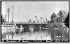 Winchester St. Bridge 1909.jpg526.5 KB · Views: 1,240
 -
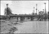 Winchester St bridge 1915.jpg447.7 KB · Views: 1,210


r937
Active Member
thanks for the mention, goldie ")
that yellow line you drew seems to cut right across the Don Branch rail line immediately after crossing the river... in fact, Winchester continued on the left (west) side of that rail line for a few dozen metres, and then went under it! (see my feeble MSPain drawing skills in attached sketch)
this Winchester Street subway looking west Toronto Archives pic shows the underpass looking west, which made me wonder what that bridge in the background is... playing around with Toronto Historic Maps, i think it's one of the bridges of the 1892-1894 Belt Line Railway, it still there in 1903 but gone by 1913
anyhow, that underpass is still there, as is the roadbed that ran on the west side of the rail line
in fact, the underpass, which is used by the Lower Don Bike Trail, is currently undergoing a rebuild to decrease its angle and improve the sight lines
Attachments

DSC
Superstar
Member Bio
- Joined
- Jan 13, 2008
- Messages
- 19,137
- Reaction score
- 26,767
- Location
- St Lawrence Market Area
Great pics - there was a long discussion of Winchester Street 'somewhere' on UT about 3 years ago. MAYBE in this thread, maybe by you? If the "Search" facility were better .....