Toronto Eglinton Line 5 Crosstown West Extension | ?m | ?s | Metrolinx

The Eglinton West line is supposed to be hilariously under capacity.

Even if it can't grab 30,000 pphd numbers with 90 second frequencies doesn't mean it'll need it.

It may end up needing more than the 15,000 that a surface LRT can provide, but I don't see a problem with the LRT being able to achieve 25,000 PPHD or so, which is plenty of capacity. That's equivalent to about a 2 minute frequency which will give more flexibility to slot in the less reliable surface trains into the network (though they may have to sit at Laird for a little bit to slot into the schedule), and would exceed the demand we see on the Bloor Danforth Line today.

It's easy to get lost in the capacity numbers and just project out infinite growth, but these things are more complex and the numbers people worry about on this board for capacity are often so insanely high and 3-4x projections. By the time the numbers could possibly be reached we are talking about another generation from now where new infrastructure can practically be implemented to reduce demand loads.
From link.

1642627402527.png

From Urban Toronto own map, showing the current development happening along Eglinton Avenue West. That's this year, there could be more in the coming years.
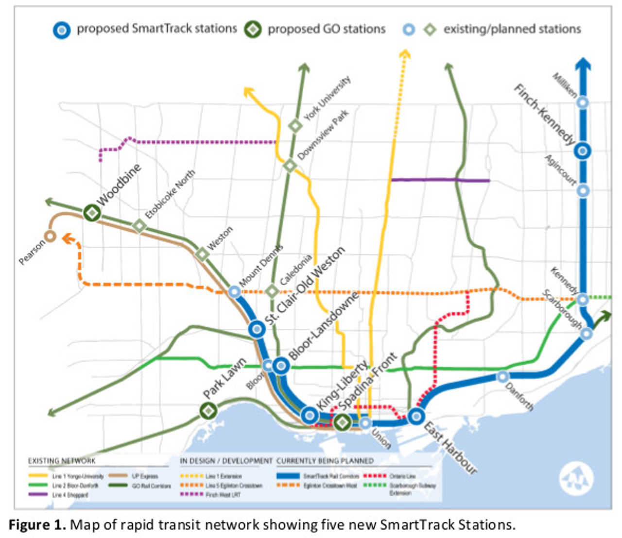
 
The statement is based on an assumption that there is enough latent demand (people currently driving during rush hour) to overwhelm the LRT capacity. The LRT maximum capacity is well within decades of transit growth on the line.

As many have pointed out, it will take years for travel patterns to change and keeping in mind the upcoming opening of the Ontario Line, it is a tough sell to state that a subway is required east of Don Mills.
1) Some trips are probably already being made by L2
2) Some people who were driving will switch
3) Those that were taken the Eglinton bus and some other EW buses will switch
4) Subway level service attracts new riders too

The section east of Don Mills will be fine. There is a lot of density planned out there but with 90m trains capable, even at 3-4 minute frequencies the line will be able to handle a huge amount of people.

It''s a short enough section between transfer points that it will struggle to fill up before people transfer off the line.

If the OL wasn't going to Eglinton I'd be a bit more concerned, but as it is shouldn't be a problem for at least 1-2 generations.
Surface LRT's rarely operate better than a 5 minute headway and 60m trains will be used from day one - and the length is deceiving they fit much less people per unit length than the similarly long Sheppard Trains

The Eglinton West line is supposed to be hilariously under capacity.

Even if it can't grab 30,000 pphd numbers with 90 second frequencies doesn't mean it'll need it.

It may end up needing more than the 15,000 that a surface LRT can provide, but I don't see a problem with the LRT being able to achieve 25,000 PPHD or so, which is plenty of capacity. That's equivalent to about a 2 minute frequency which will give more flexibility to slot in the less reliable surface trains into the network (though they may have to sit at Laird for a little bit to slot into the schedule), and would exceed the demand we see on the Bloor Danforth Line today.

It's easy to get lost in the capacity numbers and just project out infinite growth, but these things are more complex and the numbers people worry about on this board for capacity are often so insanely high and 3-4x projections. By the time the numbers could possibly be reached we are talking about another generation from now where new infrastructure can practically be implemented to reduce demand loads.
The LRT is designed to hit 15,000 at optimistic headways. The trains do not have subway door to pax ratios (only 3 doors per 30 meters, Toronto Rockets have 4 wider doors per 23 meter car) which limits headway.
 
Some riders may not want to transfer at Cedarvale or Eglinton to get downtown. With a proper GO/UPX and TTC fare integration, there would be several other stations that they may transfer to get to downtown.

44101-130395.jpg
From link.

They could transfer at Mt. Dennis, Caledonia, and later Science Centre Stations.
 
1) Some trips are probably already being made by L2
2) Some people who were driving will switch
3) Those that were taken the Eglinton bus and some other EW buses will switch
4) Subway level service attracts new riders too
1 - Yes. Connection for the OL removes any capacity issue.
2 - Agreed but I think latent demand is will be well within capacity. This is the main parameter for ridership increase. Connection for the OL removes any capacity issue.
3 - It's a bus route today and well within LRT capacity.
4 - Same as #2

Coming out of COVID + the new hybrid work model, ridership won't be "normal"until 2025 or 2026. Between 2026 - 2033 (at the latest for the OL), I don't see any reason for the Crosstown to be near capacity.
 
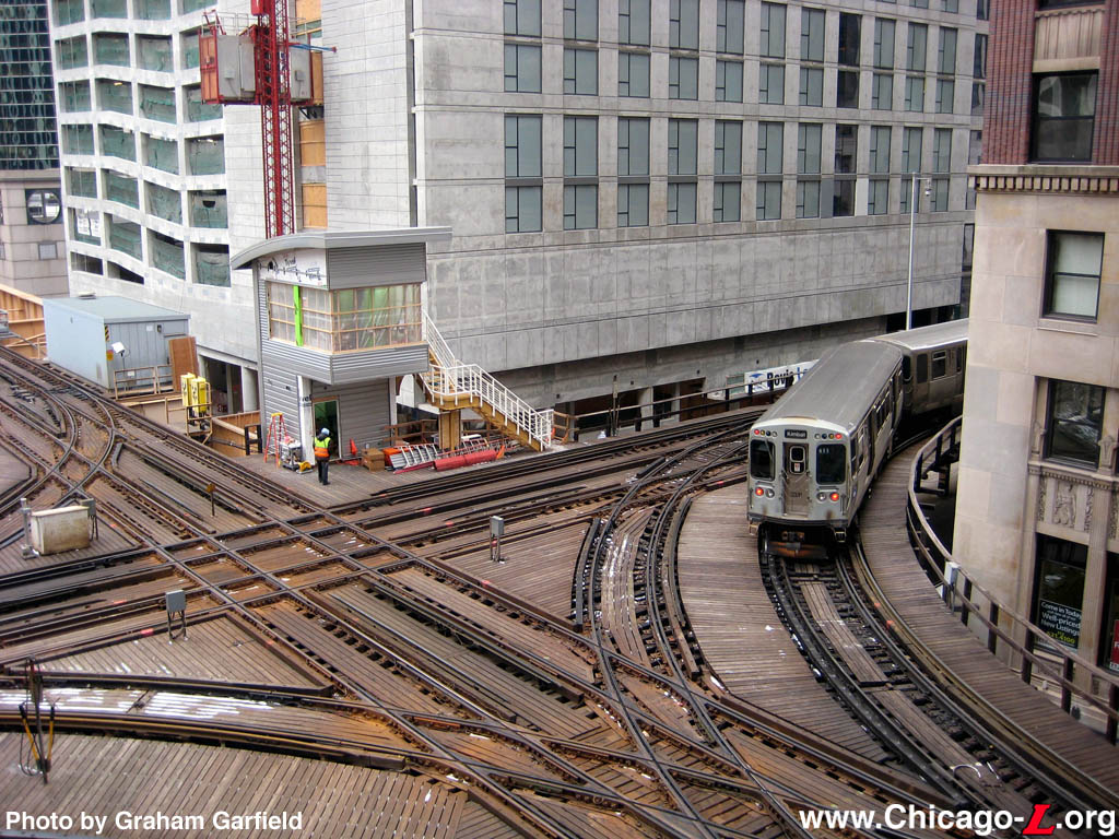
If the Jane and Eglinton interchange were ALMOST like the Chicago "L", likely they'll need only a southbound to eastbound and westbound to northbound track switches.

tower18p.jpg


However, the Eglinton platforms would likely be WEST of the intersection and the future Jane platforms would likely be SOUTH of the intersection.

Unless they go with a northbound to eastbound and westbound to southbound set of switches, then the Jane platforms could be on the NORTH side of the intersection.
 
At one time, there was no Eglinton Avenue West in the Township of Etobicoke. Instead, there was a Richview Sideroad.

From link.
1969135_611378445597775_1561473869_n.jpg

1970708_611378742264412_1272507497_n.jpg

1549463_611379392264347_760294676_n.jpg


Today, what remains is a "Richview Road", which dead ends before Eglinton Avenue West. There are plans to cut off the driveway from the high-rises at the northwest corner of Eglinton & Scarlett.

1643467156931.png

From link.

During construction of the exit portal for the LRT, they will also be narrowing Eglinton Avenue West to one lane in each direction. We should reconnect Richview Road (Richview Sideroad) to Eglinton Avenue West, maybe with traffic lights, and make it permanent. Maybe with bus stops there, since the high-rises have put lockable gates to prevent residents north of them from accessing the pedestrian bridge over Eglinton Avenue West.

BTW. The station at Royal York Road & Eglinton Avenue West could be named "Richview Sideroad" or something like that as a historical reference.
 
Last edited:
This is Richview Road (Richview Sideroad) today. Eglinton Avenue West used to be like this road before it was widened to a want-to-be expressway stroad.

1643483833778.png
From link.

Here, Richview Road dead-ends, but we can see that it could be reconnected with Eglinton Avenue West at this point, preferably with traffic lights and bus stops.
Untitled 3.jpg
From link.

There's a driveway into the Scarlett Heights Retirement Residence across the street at Eglinton. The traffic lights could provide access to them as well.
 
Last edited:
This is Richview Road (Richview Sideroad) today. Eglinton Avenue West used to be like this road before it was widened to a want-to-be expressway stroad.
Is Eglinton Avenue West really a stroad? There are very few driveways, I'd argue it serves its purpose as a road quite well. It doesn't pretend to be a street and most access to business and houses are off of side roads. The sidewalks and pedestrian paths are set back from the road to provide safety. Ideally the do some pedestrian and bike friendly intersection improvements during subway construction, but beyond that Eg West can remain a road to provide an E-W thoroughfare for traffic.
 
Is Eglinton Avenue West really a stroad? There are very few driveways, I'd argue it serves its purpose as a road quite well. It doesn't pretend to be a street and most access to business and houses are off of side roads. The sidewalks and pedestrian paths are set back from the road to provide safety. Ideally the do some pedestrian and bike friendly intersection improvements during subway construction, but beyond that Eg West can remain a road to provide an E-W thoroughfare for traffic.

It seems wasteful to put a subway under a road that prioritizes car traffic. People want to get off the subway and walk into a grocery store after work, to a nice cafe, restaurant or bar, or to a public space. They don't want to have to waste time taking a series of buses after taking the subway and then walking through a massive parking lot to get to a business so that it takes them twice or three times longer to get around. The people on the subway are "traffic" too.

To plan a subway under a street and then not encourage it to be pedestrian friendly with many businesses fronting onto it and residences in close proxity seems like clueless transit planning by people who always intend to drive for every task. Then, when people actually want subways in dense and pedestrian friendly areas, they're told there's no money or no one will ride it.

The money was already spent making driving cushy in the suburbs by taking transit off the street and placating the same NIMBYs who will also be opposing densification. The subway is more than just a tool to raise the property values of suburban homeowners with 3 cars in their driveways while keeping their private vehicle commutes as convenient as possible. It's a way of developing the city and discouraging car use. But it has to go hand-in-hand with the right land use, which means increased density and mixed-use zoning.
 
One of the first things I would change is the NO PARKING signs on Eglinton Avenue West in Etobicoke. Especially on the south side. It's a park, use it as a park. Even if people end up using their cars to get to the park on Eglinton Avenue West.

1643487421916.png
From link.

With construction, especially the stations, they will need parking spaces for the construction trucks, dump trucks, cement trucks, excavators and construction equipment, and the occasional personal vehicles of the construction workers. Better to turn the "NO PARKING" areas on Eglinton Avenue West over for construction parking. (Then leave it for parking afterwards.)
 
Last edited:

Back
Top