News   Jan 03, 2025
 1.3K     1 
News   Jan 03, 2025
 1.4K     0 
News   Jan 03, 2025
 1.9K     0 

407 Rail Freight Bypass/The Missing Link

One huge assumption on this map is that both CN and CP can fit in the existing 401 underpass. I don't think they can. This was why I drew an entirely new overpass in my map, which used the ROW associated with the CN spur north of the south Halton curve.

What 401 underpass? Any crossing of the 401 will be on the new alignment between CP and the 407 and CN at Bramalea.

Dan
Toronto, Ont.
 
What 401 underpass? Any crossing of the 401 will be on the new alignment between CP and the 407 and CN at Bramalea.

Dan
Toronto, Ont.


I think what DonValleyRainbow was referring to is the existing 401 bridge over the CN Halton Sub on the north end of Milton, pictured below, if the bypass was built north of the 401 using b) pictured below. Do I have that right DonValleyRainbow?

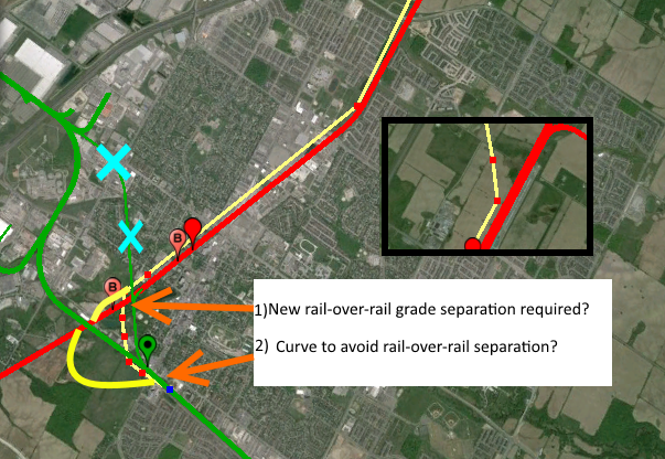
It looks like that bridge can only handle two tracks, so if CP were to use the 401 northern route, it may have to be expanded. So I guess it will be a cost comparison between expanding this bridge for route B) or a new track west of the Milton Station for the CN-CP connection for route A) and possibly a rail-over-rail grade separation.

2cU0Jle


2czrw7f
 
Why is the most obvious alignment being ignored? The original Hamilton and Northwestern (the skinny line with the orange arrow 1) indicated) used to have a chord to the then Credit Valley mainline. That RoW is still extant, albeit now parkland. If you check Google Earth, you can see there is not building on it. In fact, the original bridge still exists over the creek. If there's to be construction to re-establish the historical curve connection between the two, it's that much easier an engineering task to build a fly-over to twin it at the same time, using the same RoW. The angles are already opportune, why not use them?

The talk about doing a by-pass around Milton is just a no-go at this time, and makes little if any sense anyway. The challenge is to connect CN freight going north-south on the ex Hamilton Northwestern south of the CP main to go east-west east of the CN line south of the CP main. This is exactly what the IBI report addresses, albeit the exact details of the connection are not published. If freight is diverted as described, a flat junction is all that's needed on the present CN alignment, traffic will be almost non-existent on the northern leg of the line up to Georgetown. The only flyover needed is on the present CP (or adjacent to if CN runs parallel lines) intersection that would occur from western CN traffic on the CP alignment to the south on the present CN alignment down to Burlington.
 
Last edited:
Here is the historical chord from a kmz file overlay on Google Earth: (the overlay is over a very recent (last year) Google Satellite image. The RoW is there for the using, only loss is wilderness adjacent to a park)

upload_2016-9-12_22-51-48.png
upload_2016-9-12_23-8-2.png

The old chord is still extant:
upload_2016-9-12_23-9-28.png


Source for personal photos:

mike112358
and:
http://www.panoramio.com/photo/3190066

Photo details
  • Uploaded on July 8, 2007
  • © All Rights Reserved
    by gregorypleau
 

Attachments

  • upload_2016-9-12_22-51-48.png
    upload_2016-9-12_22-51-48.png
    2.3 MB · Views: 899
  • upload_2016-9-12_23-8-2.png
    upload_2016-9-12_23-8-2.png
    390.5 KB · Views: 803
  • upload_2016-9-12_23-9-28.png
    upload_2016-9-12_23-9-28.png
    351.1 KB · Views: 786
Last edited:
I think what DonValleyRainbow was referring to is the existing 401 bridge over the CN Halton Sub on the north end of Milton, pictured below, if the bypass was built north of the 401 using b) pictured below. Do I have that right DonValleyRainbow?

It looks like that bridge can only handle two tracks, so if CP were to use the 401 northern route, it may have to be expanded. So I guess it will be a cost comparison between expanding this bridge for route B) or a new track west of the Milton Station for the CN-CP connection for route A) and possibly a rail-over-rail grade separation.

2cU0Jle


2czrw7f

Yup, you got it. That fact would make an alignment south of the 401 a cost efficient option.
 
It isn't. That is basically the alignment that Aecom has chosen on the preliminary design drawings, but with a bit of massaging to get the speeds up.

Dan
Toronto, Ont.

One complication with the "obvious alignment" compared to a 401 or greenfield alignment is the need for a rail-rail grade separation between the new missing link corridor and CP Galt Sub.
 
It isn't. That is basically the alignment that Aecom has chosen on the preliminary design drawings, but with a bit of massaging to get the speeds up.

Dan
Toronto, Ont.
Indeed, but I mean to some of the posters. Paul and yourself have discussed the loss of some of the parkland to re-institute this, albeit with a twin leg, one of which would be a flyover, but not only is this obvious in an engineering sense, it might well be in a legal sense too in terms of being an extant RoW under the Transportation Act.

The loss of parkland, which looks incredibly serene, is unfortunate, but the RoW will save vast amounts of other green spaces and buildings being torn down.

I must admit, I was amazed when I dug out those pics of the track still extant, and it's certainly not the original Hamilton & North West, it's pretty heavy rail. I suspect that chord was used even after the diversion was built.

Edit to Add: Unless the view direction is mis-stated below, it appears there were two chords connecting the junction. In the event, that looks like The Escarpment in the background, and the train is travelling north, and one wonders what the track still extant in the photos posted previously is?:

7-milton-crossing-june-1959-rjs.jpg

The Milton, Ont. crossing, looking towards Milton. June 1959. The transfer track between the CNR and the CPR had already been removed, but the roadbed is still visible beside the train. Robert J. Sandusky photo.
 
Last edited:
One complication with the "obvious alignment" compared to a 401 or greenfield alignment is the need for a rail-rail grade separation between the new missing link corridor and CP Galt Sub.

Are you thinking that the CN tracks would be separated from the CP ones?

Because if you are, you're wrong. They'll all be shared.

Dan
Toronto, Ont.
 
Are you thinking that the CN tracks would be separated from the CP ones?

Because if you are, you're wrong. They'll all be shared.

Dan
Toronto, Ont.

Do you think they may want to build a rail-over-rail or rail-under-rail grade separation to provide the option (see the yellow lines) of trains going from the north side of the tracks to southbound as I've shown in this picture? This would reduce conflicts with CP trains continuing westbound and GO trains to Cambridge. I take your point that the tracks between Meadowvale and Milton would be shared between CP/CN/GO. I realize it's pretty early in the process so this is all speculation.

2cmKsGQ
 
Do you think they may want to build a rail-over-rail or rail-under-rail grade separation to provide the option (see the yellow lines) of trains going from the north side of the tracks to southbound as I've shown in this picture? This would reduce conflicts with CP trains continuing westbound and GO trains to Cambridge. I take your point that the tracks between Meadowvale and Milton would be shared between CP/CN/GO. I realize it's pretty early in the process so this is all speculation.

I don't know if that's what they've got planned to be honest. It does make a lot of sense as doing so would likely help deal with the level crossing at Martin St. It would also put CP on the south side of the corridor, which would then make some sense for how they have currently drawn the connections with the Mactier Sub.

But I haven't seen the detail diagrams for this particular part of the alignment yet, so I just don't know.

Dan
Toronto, Ont.

Just to fully facilitate this discussion of the need for a rail-rail grade separation, potential conflict are (assuming CP would continue along CN Halton and York subs to eastern Toronto):
  • CP
    • South: the intermodal yard on the south side of the Galt, east of Milton
    • South: industrial spur customers on the Galt sub southeast of the 401/407 interchange.
    • North+South: The MacTier sub
    • South: Toronto Yard
    • North: Belleville sub
    • North: Havelock sub
  • CN
    • North: spurs on the west end of Milton
    • South: Halton sub to Burlington
    • North+South: industrial customers along the Halton and Weston subs
    • South: Industrial spurstowards Pearson, south of Halwest
    • South: Industrial spurs along Halton sub, east of Halwest
    • North: Brampton Intermodal Terminal
    • North: MacMillan Yard
    • North: Bala sub
 
I don't know if that's what they've got planned to be honest. It does make a lot of sense as doing so would likely help deal with the level crossing at Martin St. It would also put CP on the south side of the corridor, which would then make some sense for how they have currently drawn the connections with the Mactier Sub.

But I haven't seen the detail diagrams for this particular part of the alignment yet, so I just don't know.

Dan
Toronto, Ont.

Thanks as always Dan. I've spent so much doing map options for the Milton and Meadowvale section that I haven't had a chance to look at the CP Mactier-CN York Sub interchange and the potential options. I've drawn the below image to show in yellow tracks reaching the south side and in blue tracks reaching the blue side, with rail separations needed on the east and west. These are just conceptual and I have no idea if the curves I've drawn could work.

This location looks to be one of the most complicated and expensive areas of the Missing Link/bypass because of the grade difference, the Humber River, existing buildings, and the 407. It would be fun to watch it constructed though!

2cb5RBF
 
Another topic: CP

From the Junction Triangle Rail Committee neighbourhood community Facebook group.... see Kevin's reply in the comments at the bottom.

It appears CP might be trying to get an eventual "in" the Bypass!

Arch enemies, but apparently not on this matter?

image.jpeg
 

Attachments

  • image.jpeg
    image.jpeg
    400.8 KB · Views: 579
Last edited:
In case it has been overlooked, CN and CP have co-operated a number of times before:
From the IBI Report:
[...]
5.6.4
Encouraging Coproduction by the Two Major Freight Railways
Over the last couple of decades the two major railways have improved their efficiency by joint
use of trackage, called “coproduction” in the railway industry.
The first major implementation of
this was in the Fraser Canyon area of British Columbia.
Both CN and CP have single track lines
from Kamloops to Vancouver.
A double track railway provides much greater capacity than the
sum of two single lines and offers faster transit times.
CN and CP made an agreement whereby
the CN line is used by westbound trains and the CP by eastbound trains between Vancouver
and Kamloops.
Such coproduction agreements are in place in other parts of Canada including
between Parry Sound and Sudbury.
The new connections envisaged in this report would
also
prepare the way for coproduction to be
extended from Toronto to Sudbury on the transcontinental lines of the two railways
and perhaps
eventually eastward to Montreal.
[...]
https://www.milton.ca/MeetingDocume.../ENG-020-15 The Missing Link Final Report.pdf
 

Back
Top