


jcam
Active Member
We can now have GO, the Northlander, the Eastlander, then maybe the Southwestlander.It alleges that the government's intend ia to dump legacy VIA on the provinces.
|
|
|
We can now have GO, the Northlander, the Eastlander, then maybe the Southwestlander.It alleges that the government's intend ia to dump legacy VIA on the provinces.
But wouldn't using the lakeshore route; i.e. CN Kingston sub, etc., either in whole or part, be challenged by ROW capacity and ownership? Shoehorning at least two dedicated high speed tracks, stations, infrastructure, stations, etc. would seem to be no mean feat. If not 'the corridor', the closer you get to the lake, the higher the land cost (in general).

 en.consultation.altotrain.ca
Corridor mapping now live.
Shaping the Canada of tomorrow with high-speed rail
The train we need Alto’s aim is to build the country’s first high-speed rail network that will run at speeds of 300 km/h or more to efficiently connect major cities in the Toronto–Québec City corridor. Fast, reliable and frequent: Alto will reinvent the way we travel
Interesting from the perspective of the most recent discussion that the Ontario study area still seems to include Peterborough, then provides two corridor options towards Ottawa. There's a lot of geology and other factors involved and it would be interesting to know what the logic of two potential corridors are. The Frontenac Arch ('Canadian Shield') is only marginally narrower to the south and its not like there are any communities they trying to hit (or avoid).
 en.consultation.altotrain.ca
Good grief, that southern alignment. Imagine coming that close to Kingston and not stopping there.
350 km/h operational top speeds on ballasted track would be a world record. Also I am pretty sure ballast flies and hits the undercarriage too much above 320 km/h. There is also a big aversion to scope creep on this thread, not that the opinions of forum dwellers should take precedence over Alto staff and consultants.The Alto high-speed rail network: Designed for performance, with safety in mind
1. High-speed rail components High-speed rail has proved itself worldwide, including in France, Japan and Spain. These networks are known for being efficient, safe and for improving connectivity between cities. Alto draws on these models by considering Canadian
They mention a minimum curve radius of 7km. In China that is good enough for 350 km/h.
They're using ballast but maybe that was expected for the lower capital cost.
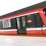
No text, but maybe noteworthy that these are single level trains unlike bilevel as suggested by Mr. Schabas
They could call the station Kingston North, like the HSR stations on the outskirts of town that are common in China. Could spur development north of Kingston.Good grief, that southern alignment. Imagine coming that close to Kingston and not stopping there.
On the plus side, the city would instantly become a major producer of salt.
")