Toronto Lower Don Lands Redevelopment | ?m | ?s | Waterfront Toronto

Yikes that is really high. I wonder where it goes when it overflows? I didn't think the flood zones would be needed after some normal spring rains.

What's weird is that looks higher than the Keating Channel behind it which is lake height. But this should be lake height too since it's now connected to Lake Ontario at the south end. I wonder if its somehow trapping water. It is open to the lake on the south end.
Isn't it connected to the spillway/wetland that is a continuation of the riverbed going south to the Ship Channel?
 
  • Like
Reactions: max
Love how this rendering from just a year ago shows double orange and double lemon bridges. 😆

Screenshot 2024-04-20 at 8.36.38 AM.png
 
Yikes that is really high. I wonder where it goes when it overflows? I didn't think the flood zones would be needed after some normal spring rains.

What's weird is that looks higher than the Keating Channel behind it which is lake height. But this should be lake height too since it's now connected to Lake Ontario at the south end. I wonder if its somehow trapping water. It is open to the lake on the south end.
According to the Weather Channel, we haven't had "normal" spring rains - it's been very wet. 7th rainiest on record!

1713621421834.png
 
Rode through the area this afternoon. It is still really high. Basically just barely spilling over the top into the surrounding area a little bit.

I gotta think some of that is that despite the southern plug being partially removed it's not able to drain into Lake Ontario properly the way it will when it's fully opened at both ends (maybe some will also spill into Keating Channel?)

Otherwise we are going to see LOTS of flood events.
The 'spillway' going south into the Ship Channel is there to deal with high water events, this is to avoid 'flood events' and if water goes south into it, it should really not be called one.
 
Are Sakura Cherry trees native or invasive?
...probably Northern Light-sensei will likely have a more detailed answer for this. But I reckon since they're not growing everywhere, I am going to wager a "no" on that.
 

May 2: Villiers Island Density Study In Person Drop In​

af2756fe-9fcb-4c13-b28a-542b89969bbb.png

Learn more about the plans for ‘Villiers Island’ and the future opportunities for public input.​

Port Lands Flood Protection opens 240 hectares of underused post-industrial land for development near downtown. That work will be completed by the end of 2024, with new parks and greenspaces opening in 2025. ‘Villiers Island’ is the planned community that will develop on the new island created by the rerouted Don River as part of Port Lands Flood Protection. This island is almost entirely public lands, and presents an opportunity to build new housing, including affordable housing.
The City of Toronto, CreateTO and Waterfront Toronto were tasked with finding ways to increase density to deliver more housing. Including affordable housing, without compromising the vision set by the Villiers Island Precinct Plan and Port Lands Planning Framework for a sustainable, complete community.
A public meeting in June 2023 presented possible approaches to increasing density on the island. The Density Study is now complete, and the project team is reporting back with the proposed approach to updating massing (or buildings) set by the Villiers Island Precinct Plan.
957d23ee-ceee-42c3-97e9-8ed8e882f2d8.png

Meeting Details


At a virtual public meeting in March 2024, we shared the recommended approach to increasing housing, including affordable housing on the new island, that resulted from a Density Study. In this meeting, team members from the City of Toronto, CreateTO and Waterfront Toronto presented the next steps for ‘Villiers Island’, including future opportunities for public input. This presentation was followed by a Q+A .
To follow up this virtual presentation, we are hosting an in- person drop in on Thursday, May 2 at 251 Queens Quay East from 7:00 p.m. - 8:30 p.m.
Details presented in the meeting will be on display and project staff will be available to answer questions.
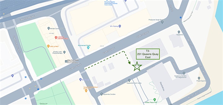
Please note that the front door is at the side of the building per the map below.
https%3A%2F%2Fcdn.evbuc.com%2Fimages%2F746074659%2F125288548375%2F1%2Foriginal.20240417-185129

How to get there:
By bike: The building is located off the Martin Goodman Trail. There is bike parking on either side of the building.
By transit: Take the 19 or 72 bus to Dockside Drive (George Brown College), then walk east to 251 Queens Quay East.
By car: Turn on to Merchant’s Wharf from Queens Quay East, then turn left on Edgewater Drive where you will see the entrance to the building’s paid underground parking.
Register to receive a reminder for this meeting, and other related information. Registration is not required to attend. A summary from the March 26 and May 2 meetings will be available after the drop in. Please let us know about any accessibility accommodations. If you have any questions, please email info@waterfrontoronto.ca.
 

Back
Top