News   Mar 28, 2024
 1.4K     3 
News   Mar 28, 2024
 687     2 
News   Mar 28, 2024
 942     0 

Ottawa Transit Developments

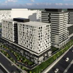
Pragmatically, kEiThZ has the more politically realistic 25-year masterplan here. (Bank St subway obviously being a ~2040ish thing when density warrants, including a mixed-use Billings Bridge multi-skyscraper complex development plan, as well as general slow eventual densifications along Bank).

It might not be the dream of a beautiful Bourdeaux-style LRT along the canal, but it is realistic in the longer term.

projeton33.jpg

(Credit: Systra)

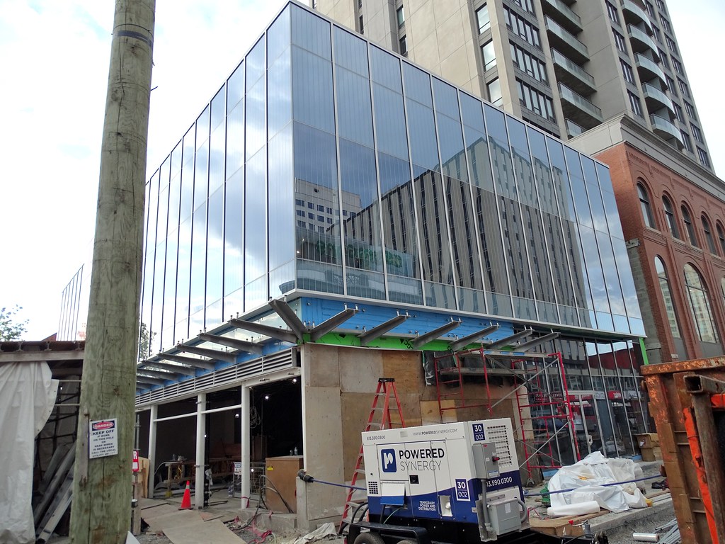
Once Ottawa gets addicted to LRTs -- and I expect they will after Phase 2 -- the pressures against densification along Bank Street will slowly dissolve if people realize we can get a Bank Street Subway in exchange for permitting major densification along the Bank St axis. It won't be a Bourdeux masterpiece, but it is far easier easier politically than a Rideau Canal LRT.

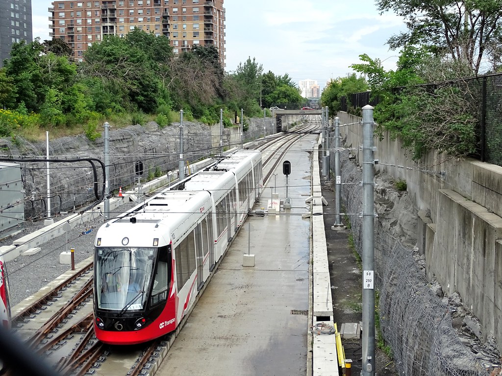
If I was a betting person, I'd first politically bet on a Bank Street subway over the drreamy/preferred Bordeaux-style Rideau Canal LRT by 2040s+
 
Last edited:
I'm not proposing routing via the Canal because it's the best corridor for densification, I'm proposing it because a) it's the path of least resistance, and b) it's significantly less expensive than tunnelling from Billings Bridge. With this proposal, you'd only need to tunnel from Pretoria to Queen, not from Billings Bridge to Queen. The former is about a third of the length of the latter. Also, this proposal hits Carleton, which is a huge trip generator. In addition, I think most of the densification along the Bank corridor will occur north of the Queensway, not south of it.

I definitely do see the merits in a subway directly underneath Bank St, I just think a tunnel that long won't fly in Ottawa, even in the 2040s. Don't forget, even after the 2031 network is complete, there are still secondary lines like the Orleans South line to be built.
 
It certainly would be significantly less expensive. I fear it won't be politically easy though.

Let's look at politically easier land-value capture. Think about this for a second.

I agree most densifications will happen north of Queensway. But clusters do occur. Look at what happened in Toronto's York region. Eglinton+Yonge. Liberty Village. Etc. That will happen to Ottawa within 50 years when Ottawa goes full on LRT. Look at the 60 storey tower now approved at Bayview, for example -- skyline shattering for Ottawa and practically declares a brand new densification node.

That's going to happen at a bunch of other places too. My prediction by year, 2100 is a Billings Bridge superdensification cluster and a South Key superdensification cluster. I think a Canal LRT is arguably more contentious (for many factors, not just NCC and rich tenants near canal) than a theoretical Billings Bridge superdensification cluster Yonge-Eglinton style.

Even if not 2040, then Billings Bridge superdensification by ~2100 -- there should be less suburb resistance there (by then), it's a major rapid transit station (that could someday become an interchange station between two LRTs -- the converted Transitway + Bank Street subway).

Yes, I predict far sooner than 2100, but I merely say 2100 -- for convenience's sake -- because that's practically guaranteed to happen if LRT is extended to Billings Bridge. Who knows, it might be a token cluster of six or seven 20-storey, but could be a expanded cluster of dozens of buildings much taller than that especially if it expands eastwards to take over the old Data Centre areas and other parking-lot officeparks. There's incredible densification-node potential that will just literally explode at the intersection of any two LRTs (e.g. the intersection of a Bank Street Subway and the existing Transitway-converted-to-LRT) -- an area, combined, larger than the Byward Market, by parking-lot surface area in the vincinty -- without removing grass -- but with more densifiable potential with fewer surrounding suburbanites/rich tenants to resist development. There's more asphalt room to densify at Billings Bridge than the low-density area whereere the 60 storey building is at Bayview literally0 adjacent to rowhomes, so a tall-tower-style cluster at Yonge-Eglinton may also happen at Billings in half a century or less.

There's plenty of room for two or three major densification clusters to start incubating south of Queensway within 25 years. For example, just at Billings Bridge alone, that big surface lot (nearly the size of Byward Market -- but when combined with Data Centre parking lot too, surface as big as Byward Market in total size) -- all this practically go underground with the land-capture value of a major two-LRT interchange station connecting there. The mall won't stop, it'll just slowly convert into a CBD in a Yonge-Eglinton style manner, thanks to Ottawa's equivalent of an axis subway ala Yonge subway.

Mathematically calculating area in Google Maps -- I notice -- conveniently, all that nearby asphalt the size of Byward Market in surface area, has protected for a potential future densification node at the intersection of two future LRTs. Obviously, it doesn't happen this decade, but over a few decades -- this incredible land value justifies the more-expensive Bank Street subway (LRT tech) as being the political easier solution in the next 25 years (or pessimistically, next 50 years).

Not saying, I do prefer a Rideau Canal LRT. I agree on that too. Cheaper. Prettier. But I have less hope on that happening, given what I know of the barriers against it happening along the canal -- pie in the sky if we can get past the resistance, IMHO...

But I think it's politically easier to spend extra money. To do Phase 1, Phase 2, and Phase 3 to give enough LRT to Ottawa to make population start demanding an expensive Bank Street subway (LRT tech) while still resisting a Canal LRT. Culturally, Rideau Canal LRT isn't going to as easily happen as a Billings superdensification node Yonge-Eglinton-style.

There's a lot more unlockable land-value capture -- to tempt governments -- along Bank Street than along the canal, to the point where it's cheaper political capital on the more-expensive Bank Street subway.

Just see Toronto's crazy Scarborough Subway extension -- and one argues even a Bank Street subway (LRT tech) makes way, way more sense (~2040s+), far better land-value unlock (dollar for dollar), far better long-term taxpayer return, and transit-benefits, than that 1-stop abomination of spend that Toronto seems to be resigned to.

I've seen this clustering pattern happen that a gradual/eventual Billings Bridge superdensification cluster is pretty much a shoo-in prediction if there ever ends up being an intersection of two LRTs at Billings. Then again, maybe not.
 
Last edited:
You raise some very good points about the Billings cluster. Like I said, I'm not opposed to a Bank St Subway by any means, I just think that the sticker shock of it would never get it off the ground. Even if we could do a Bloor-Danforth style cut-and-cover right behind the street-fronting buildings, we're still looking at a $3-4 billion project to go from Billings to Downtown. Yes, I think that using the Canal would result in lower ridership and a lower potential for densification, but if that price tag can be cut in half, it may make the difference.

As for other conversions and serving Billings, if the Trillium Line north of Mooney's Bay does get routed straight towards downtown (via either Bank or the Canal), what I'd like to see is a U-shaped line using the current Trillium Line from Mooney's Bay to Bayview, and a conversion of the SE Transitway from Heron to Hurdman. It would basically act as a bypass of downtown, and would connect to the Carling LRT, Carleton University, Billings Bridge, the Hospital sector, and Hurdman. Given that it would be using a combination of existing track and/or existing transit ROW, it could be done relatively inexpensively.
 
Sorry, but other systems do throw good money at low ridership line for high order.

Transferring is a fact of life, as single seat rides does not fit everyone trip needs, as well taking longer to do it.

I should had made a video of the transit at "Bay" Bus Stop off peak, to show why an LRT is need.

I am not surprise to see this, as it was my assessment based on what I was seeing first hand for the first time that the line wouldn't see service until 2019, regardless doing 7/24 work.

I am about a day or so from having photos on line for the line.

Alstom is behind schedule to have all cars for service in Nov, if the line does start.

Ottawa's light rail transit delayed once again
unfortunate.
 
There is no chance of running LRT along the Canal as that is controlled by the National Capital Commission who almost blocked Phase 2 of the LRT in a far less scenic/touristy area and is the type of organization that would take 5 years to determine the colour of the sky.
 
There is no chance of running LRT along the Canal as that is controlled by the National Capital Commission who almost blocked Phase 2 of the LRT in a far less scenic/touristy area and is the type of organization that would take 5 years to determine the colour of the sky.

This is the same NCC that:
If there was ever a useless public agency that should be dissolved with extreme prejudice, it's the NCC.
 
This is the same NCC that:
If there was ever a useless public agency that should be dissolved with extreme prejudice, it's the NCC.
Blame the NCC for the failure to rebuild Lebreton Flats for over 50 years, but they are not responsible for the other issues that you describe. Those were political decisions made by the federal government to implement the Greber Plan.
 
There is no chance of running LRT along the Canal as that is controlled by the National Capital Commission who almost blocked Phase 2 of the LRT in a far less scenic/touristy area and is the type of organization that would take 5 years to determine the colour of the sky.
Correct. There is no way that we will place LRT along the Rideau Canal with the idea of intensifying the corridor. This will destroy the charm of the area. It may be more expensive to tunnel under Bank Street, but there is no need to build another indirect route from the south end. We already have two. If another is to be built, it needs to be a straight line and service planned growth nodes (Billings Bridge and South Keys in particular) and encourage intensification in general along the corridor that is already a business district.
 
Even completely without NCC -- and their boosters and detractors -- being Ottawa born and spending lots of time along the canal -- there will be far more population resistance against a Canal LRT than against a Billings superdensification plan.

At least in the Phase 2 completed era. The stupendously expensive cost will keep that a paper plan for probably 25-50 years but then suddenly happen once cost-justified to a population now used to LRT.
 
Blame the NCC for the failure to rebuild Lebreton Flats for over 50 years, but they are not responsible for the other issues that you describe. Those were political decisions made by the federal government to implement the Greber Plan.

The NCC (well, its precurser the FDC) is who commissioned Greber in the first place. Implementation of the plan was the NCC's raison d'être.

Saying that these were decisions made "by the federal government" ignores the fact that this is the federal agency appointed by the federal government for a purpose (urban planning) that shouldn't be in its purview. Without the NCC, the federal government wouldn't have had the means or desire to propose things like leveling downtown Ottawa to create a boulevard or expropriate historic buildings and let them fall into disrepair until they need to be demolished.

But I guess, if we dissolve the NCC then who would shut down all the dangerous lemonade stands?

I am sorry but your interpretation of Ottawa history is wrong. It was Prime Minister MacKenzie King who brought in Jacques Greber. Obviously, Greber worked with the Federal District Commission in developing the Greber Plan, but MacKenzie King had a personal interest, and ultimately, the federal government approved the plan. It was Greber and MacKenzie King who were the driving force behind the plan, not the bureaucrats. What has happened with Lebreton Flats is more about NCC bureaucratic bungling. Both MacKenzie King and Sir Wilfrid Laurier adopted Ottawa as their permanent home and both set out to improve the appearance of the city.
 
Last edited:
Aug 14
Finally got around doing the photos for the LRT and uploading them. They all can be found at https://www.flickr.com/photos/drum118/albums/72157671163886277 and buses at https://www.flickr.com/photos/drum118/sets/72157601486925620/

From my point of view, Oct would be about the earliest the 3 stations I saw first hand would be finish and no time table for the ones in the downtown area since I couldn't see them, other than a few unfinished entrance.

If the O line is to go north in the future, all the paths and trails would have to be lower to get under the track.

Real odd seeing rail in the once BRT ROW. If it wasn't for the rain, would had gotten more photos. I would also have to leave the other haft some where, since she not a fan of me taking photos or spending time in one place.
44004111124_29edc62564_b.jpg

44672535412_8d0433ca3d_b.jpg

42912597690_a66b742def_b.jpg

44004147934_d2f534fd0b_b.jpg

43813182825_36f0cc64a6_b.jpg

43813168205_28df9e3f7f_b.jpg

44004150534_2b9d108135_b.jpg

43813192175_c89edf242c_b.jpg

44672612602_3a6b2baed0_b.jpg

44721721521_a16ac4b3e2_b.jpg

44672627332_a8612ff3f7_b.jpg
 
From my point of view, Oct would be about the earliest the 3 stations I saw first hand would be finish and no time table for the ones in the downtown area since I couldn't see them, other than a few unfinished entrance.

If the stations are functional by the end of November, I'd be pretty happy. My money is on February for the start of service. At this point they might as well eat the delay a bit and burn down some of the minor deficiencies list as well.
 

Back
Top