News   Apr 19, 2024
 592     0 
News   Apr 19, 2024
 618     2 
News   Apr 19, 2024
 1K     3 

King Street (Streetcar Transit Priority)

OK, then perhaps you can provide a reference for that? I get the distinct impression that I've seen a lot more pedestrian/transit malls across Europe and down the US than you have, but feel free to prove me wrong. There's a very good reason Melbourne and other cities ban bicycle riding on their transit malls.

Reference please.
Well Zach, pardon it having to be me to point out to you that King Street during rush hour is hardly representative of "Open Streets".

And yes, of course I have. Have you ever worn clean underwear?

You might be right about the first part.

As for King vs Open Streets, well, we're talking about a most car-free zone... I don't think it will be as dissimilar as you make it sound. The only difference will be streetcars, which are not exactly unpredictable machines.
 
As for King vs Open Streets, well, we're talking about a most car-free zone... I don't think it will be as dissimilar as you make it sound. The only difference will be streetcars, which are not exactly unpredictable machines.
I see....Sundays are just like any other day of the week for some...

I suggest you view the Melbourne Transit Mall vids, one is linked above.

Here's another:
 
Last edited:
On Queen I think the detractors are the institutional spaces. City Hall and Osgoode both turn their backs on Queen St (with a mini-Gardiner walkway barrier and a fence respectively). Eaton Center tries to keep people indoors with the 2nd floor and underground walkway to the Bay. And then St Mike's is also not very friendly. When I walk along Queen I do not feel it's that busy in the financial district.

Assuming it goes from Bathurst to Jarvis Queen is ideal from Bathurst to University. Then there is a void of pedestrian potential the rest of the way east.

King St does have similar institutional. Metro Hall, TIFF and Roy Thompson Hall all all there. But they also have the financial district whose landlords and employers would most likely put on events outdoors if there was additional room. Just look at the "food truck" event all summer at 150 York. There are also very few commercial vehicle requirements in the commercial district. Most if not all of the parking garages have access via another street.

King W also has lots of foot traffic (more on a weekday night than Queen W...Queen W has more on the weekends). It also has some great restaurants and bars that with patio expansions will make the street look even more busy.

Overall I beleive the key difference is east of University (and even more so east of Yonge). King through the entire strip will have pedestrian traffic where Queen has some stretches which are not as busy.

Plus of course the capacity issues....King has so much demand already plus there is a huge pent-up demand in Liberty Village for a viable streetcar line to get downtown.

Are you 100% sure about this? City staffers have repeatedly stated during The Process that a Queen subway would be best positioned to support activities outside regular business hours because City Hall + Eaton Centre or bust. ('cause King is all offices, nobody hangs out there after) It's debateable whether reserved lanes are needed east of Yonge because there's hardly any traffic on either street.

But you people bring up good points. If the idea of a transit mall is to make a downtown street nicer to walk, Queen is a 1000x better candidate than King because it has traditional storefronts and big variety of retail, live music venues, and food places. Looking at Google maps there looks to be a laneway running behind a big portion of the street so theoretically you could do deliveries there. What are you going to do on King where huge office buildings, high rise condos, and institutions like George Brown take up entire blocks with huge building frontages. (Is there an equivalent laneway for deliveries?) We already got large setbacks from Bay to John down on King (and would have been more had planning not thrown a wrench into the spokes of M+G) an extra 10 feet won't make a difference for "events". If you really cared about street events, Queen west has a huge space from Spadina to Soho built in.

However if the purpose of the transit mall is to move lots of people quickly from condo to offices at LV/Spadina/Parliament/CBD and vice versa point-to-point (and on King that clearly is its purpose) then it should be an interim measure until it can be replaced by rapid transit that is future proofed for the highest density commercial corridor in the city not on a subway. Agglomeration is only going to make it worse until we find out streetcars can't hack it.
 
@steveintoronto

Have you ever biked during Open Streets?

Pedestrians and cyclists and a million other street uses can mix very well. You just can't bike like you're in the Tour de France. You bike deliberately and make eye contact with other people using the street. It's really not difficult. Frankly, it's rather pleasant.

If you need a super highway, use Richmond/Adelaide. King won't be high speed for any mode, except for hopefully, transit. (Relative high speed compared to current conditions, but still, not exactly high speed).


Oh, so cyclists would have to pay attention to the road just like a motorist at a busy intersection who has to watch out for cyclists zooming by on both sides and pedestrians? Unacceptable /s

What about a configuration similar to Roncesvalles where you have bump-outs for Transit stops with a bike lane going around them? Have the pedestrian sidewalk elevated above the Bike/Transit lanes to distinguish the areas but not prohibit cross-movement?
 
Last edited:
Oh, so cyclists would have to pay attention to the road just like a motorist at a busy intersection who has to watch out for cyclists zooming by on both sides and pedestrians? Unacceptable /s

What about a configuration similar to Roncesvalles where you have bump-outs for Transit stops with a bike lane going around them? Have the pedestrian sidewalk elevated above the Bike/Transit lanes to distinguish the areas but not prohibit cross-movement?
Yup, as a serial cyclist, I agree completely. What's good for the goose is good for the gander. As a pedestrian, I wouldn't want cyclists thinking it's 'business as usual' in a transit or pedestrian mall. Zach's post revolved around my claim of (gist) "pedestrians and cyclists are incompatible", and I stand-by that claim, as there just won't be the space to allow either cars or bikes to have safe passage for everyone concerned. (And Melbourne's transit mall bans cyclists) I even have concerns, as stated, for pedestrians and streetcars since it is a *transit* mall, not a pedestrian one, being promoted. In other words, emphasis must be on getting the streetcars flowing as fast as possible, and that probably means barriers of some sort to separate the unthinking pedestrians from the streetcars.

That latter point is a failing I see in the Melbourne model, as the vids show (Ironically, I was watching the linked one and more last night to study it further) and they crawl through the Bourke St transit mall section with all-way flashers on, and *still* have to consistently beep at pedestrians to get out of the way. Unfortunately, barriers are not going to be popular with merchants or pedestrians, so this is a point that requires far more discussion. The barrier could be 'green' as is done in sections of Paris. The beauty of Andrew's (Gweed's) suggestion a few weeks back is keeping cyclists separated from streetcars and pedestrians, but as good as it is, the amount of room available on King just doesn't appear conducive.

Roncesvalles is immediately south of me, I use it all the time as pedestrian (mostly with dog) or in clement weather, to cycle. It works, with caveats, but it is a compromise from so many angles, and is *safer* for cyclists, but not so for pedestrians, many of whom wander onto the delineated cycling lane. Many cyclists not only fail to make way for them (whether they're in the right/wrong or not, pedestrians must have RoW), but zoom through the crosswalks barely missing schoolchildren and mothers with babies. Many cyclists do not help 'the cause'. Thus for King, I repeat "either a dedicated bike lane, or none at all"....and pragmatism dictates the latter.
Have the pedestrian sidewalk elevated above the Bike/Transit lanes to distinguish the areas but not prohibit cross-movement?
That would clearly delineate pedestrian from cyclist (for most, anyway) but the problem will still be cyclists zooming past open streetcar doors.
-----------------------------

Something I'd like to add is that instead of 'either/or' for King v. Queen, and this has been raised by other posters prior, it would do well to consider 'both together' in some manner or other, either bi-directionally (one direction on one, other direction on other) or one express, the other local for streetcars, and/or in central sections, one become completely pedestrians with the streetcar flow detouring on the other (most like Queen completely pedestrian in core, and King handling both K and Q streetcars via, say Bathurst and Victoria. Once Queen is reattained, the Q streetcar runs local, and the King cars run express.

Any proposal is a compromise of many factors, but the best compromise might be by including both K and Q in a scheme together.
 
Last edited:

So from the article, these are the proposals:

Option 1 - "Alternating Loops”: A single lane of one-way car traffic, to facilitate local access to driveways and deliveries, but with the direction alternating each block, preventing through traffic. Cars and trucks would also be forbidden from making left turns. The two centre lanes would be reserved for streetcars only. And the sidewalk on one side of the street would extend out to cover one existing lane, featuring customized “public realm” improvements (seating, marketplace tables, patios or performance spaces, for example) for each block.

Option 2 - “Transit Promenade”: This would see the sidewalk extended into the road on both sides for public realm improvements, while allowing local, right-turn-only car access in both directions — cars would be forbidden to drive straight through at intersections, forcing right turns at the end of each block. Cars would share the streetcar lanes except at the edges of blocks, where they would move into right-turn lanes. This option allows somewhat more room for creative pedestrian spaces while still limiting obstructions of streetcars from left turns and traffic volume, but could, the presentation notes say, still cause transit delays due to the shared use of the streetcar lanes.

Option 3 - “Separated Lanes”
: Less enthusiastically presented by Keesmaat and Gray, which offers no enlargement of public realm pedestrian space. Instead, it dedicates the centre lanes to streetcars, and gives the remaining one lane in each direction to car and truck traffic, forbidding left turns and stopping, but allowing through traffic. Staff notes suggest this option would still facilitate faster streetcar movement while offering no change in “public life” elements. Keesmaat notes this option may also wind up more frustrating for motorists who expect to be able to drive through along the street, but get held up for deliveries, cab pickups, or fender benders in the only lane available to them.
 
Many thanks for link Drum, but article appears to have been dropped by TorStar's server, or unavailable for some reason. I will post in full until it returns, and then delete this post if it does:
King St. plans still leave room for cars: Keenan


None of the proposals for improving transit flow on King St. involve excluding cars.

king-and-blue-jays-way.j.size.custom.crop.1086x658.jpg

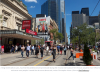
On Monday, three proposals for pilot programs for the King St. transit corridor will be presented at a meeting. (Richard Lautens / Toronto Star) | Edward KeenanColumnist
Fri., Feb. 10, 2017
Anyone who was gearing up for a fight over a car-free King St. can stand down.

The Star was given an advance look at the long-awaited proposals under consideration for the pilot project.

When the options are publicly presented at a meeting Monday night, all will include space on the road for automobiles. Perhaps controversially, none of the proposals will include bike lanes. Two of the three proposals give more space to pedestrians and public realm improvements such as seating or patios. And all are intended, first and foremost, to “move people” by giving priority on the road to streetcars, according to Toronto general manager of transportation Barbara Gray and chief planner Jennifer Keesmaat.

“Transit first is the frame around which we’re going to lead this decision,” Gray says.

“The objective is to create a transit priority corridor. The objective isn’t to create a car-free corridor,’” Keesmaat says. “It’s about being transformational, improving streetcar operations, and innovative placemaking.”

City staff members will present three options to the public for consideration a meeting at Metro Hall on Monday evening at 6:30, the start of a public consultation process during which proposals will be evaluated and refined over the next few months. A final recommendation will be voted on by city council in July, and if approved, will launch on the street for a pilot project period this fall.

The pilot area runs along the downtown length of King St. from Bathurst in the west to Parliament or Jarvis in the east — an area selected because it is where streetcars encounter the most delay right now, and because it offers many “parallel routes” as options for cars and cyclists to travel on.

Of the three options, Keesmaat says, “Two I think we would argue do a very, very good job, and we’re going to be recommending. The third is a less ambitious option,” put forward in case the “public appetite” for change proves lower than the project’s designers hope.

The first option recommended by planning and transportation staff is labelled “Alternating Loops.” It would allow a single lane of one-way car traffic, to facilitate local access to driveways and deliveries, but with the direction alternating each block, preventing through traffic. Cars and trucks would also be forbidden from making left turns. The two centre lanes would be reserved for streetcars only. And the sidewalk on one side of the street would extend out to cover one existing lane, featuring customized “public realm” improvements (seating, marketplace tables, patios or performance spaces, for example) for each block.

The second recommended option is called “Transit Promenade.” This would see the sidewalk extended into the road on both sides for public realm improvements, while allowing local, right-turn-only car access in both directions — cars would be forbidden to drive straight through at intersections, forcing right turns at the end of each block. Cars would share the streetcar lanes except at the edges of blocks, where they would move into right-turn lanes. This option allows somewhat more room for creative pedestrian spaces while still limiting obstructions of streetcars from left turns and traffic volume, but could, the presentation notes say, still cause transit delays due to the shared use of the streetcar lanes.

The third option, less enthusiastically presented by Keesmaat and Gray, is “Separated Lanes” which offers no enlargement of public realm pedestrian space. Instead, it dedicates the centre lanes to streetcars, and gives the remaining one lane in each direction to car and truck traffic, forbidding left turns and stopping, but allowing through traffic. Staff notes suggest this option would still facilitate faster streetcar movement while offering no change in “public life” elements. Keesmaat notes this option may also wind up more frustrating for motorists who expect to be able to drive through along the street, but get held up for deliveries, cab pickups, or fender benders in the only lane available to them.

In all three cases, the TTC will be running new, larger streetcars for the duration of the pilot in order to allow for more reliable service and more passengers, and transportation services will be giving streetcars priority at traffic lights.

Detailed statistics about the changes in streetcar performance, business and pedestrian volume, and traffic volumes in the larger area around the pilot site will be tracked to measure success or failure.

Councillor Joe Cressy, who represents one of the main downtown stretches the pilot will cover, is enthusiastic about the launch. “The fact is, King St. is congested today, and it is going to get worse. Unless we rethink our streets, we will fail.” He says he believes there’s pretty wide acknowledgement from the public, from local businesses and from politicians that the current way the street operates is frustrating for motorists, transit users and pedestrians and that the pilot project is a test of a potential way out of it.

“Speed is important,” he says of the fall launch. “When pilots fail, it’s because we treat them as a permanent change,” he says, study and designing and debating them in endless detail before starting. “We have to be quick, adjustable and flexible.”

Today, the 504 King streetcar line is the TTC’s third-most travelled route — carrying more passengers each day than the Sheppard subway line, and more than the Scarborough RT — despite being notoriously slow and unreliable during rush hour. Many (including me) have suggested that even while the city debates multi-billion-dollar, decades-long transit construction projects, speeding up the operation of the 504 could provide a cheap way to ease pressure on the overcrowded Yonge subway line by providing reliable alternate routes into the downtown core.

“This is a quick win, it’s low-hanging fruit that can significantly improve quality of life in the financial district and in one of the fastest-growing areas of the country,” Keesmaat says. “We’re signalling that we’re not stuck in our ways, that we can adapt, that we can mature how we use our infrastructure. It’s a really exciting step.”
Google cache @ https://webcache.googleusercontent.....html+&cd=2&hl=en&ct=clnk&gl=ca&client=ubuntu
 
My immediate (might change) impression as best? Option 1. It satisfies the needs of business (albeit some will scream in protest and demand Option 2), and yet *dedicates with no compromise* the basic need of this exercise: Streetcar clearway.

As soon as that is compromised, as in Option 2, we're back to where we started. The question I have is how are those streetcar lanes to be protected? And how are businesses with no vehicular access on their block (vehicle lane other side) going to react to this, and/or barred pedestrian access from the other side except at signalled crossings?

As a snide personal reaction, I find 'planner talk' worse than computer nerds at parties talking 'bits and bytes':
[Keesmaat says. “It’s about being transformational, improving streetcar operations, and innovative placemaking.”] I like Keesmaat, a lot, for all her posing and pretty petulance, but she can't help but use words like "placemaking", "wayfinding" and the litany of the lingo planners love to use to impress the hoi-polloi as to how special they are...

I became allergic to the lingo from prior bouts of attending planning meetings in an earlier life...

Edit to Add: Reading back as to what Keesmaat is on record as saying, the lingo leaves a litany of language alliteration:

Keesmaat - :
[...]The “King Street Visioning Study,” recently commissioned and formally kicking off in a few weeks, aims to “develop a transformational vision for King Street and generate design ideas to improve streetcar operations, enhance the identity of this significant street and its neighbourhoods and promote walking through significant, innovative place-making initiatives and improvements to the public realm.” [...]
https://www.thestar.com/news/gta/20...-redesign-king-street-and-quickly-keenan.html

So just what does the term "place-making" mean? It's only a few decades old, and like computer nerdist, the jargon also referred to as 'computerese', the meaning is nebulous...at best. Like "awesome", it means different things to different people.
[...]When PPS surveyed people about what Placemaking means to them, we found that it is a crucial and deeply-valued process for those who feel intimately connected to the places in their lives. Placemaking shows people just how powerful their collective vision can be. It helps them to re-imagine everyday spaces, and to see anew the potential of parks, downtowns, waterfronts, plazas, neighborhoods, streets, markets, campuses and public buildings.

Placemaking is not a new idea. Although PPS began consistently using the term “Placemaking” in the mid-1990s to describe our approach, some of the thinking behind Placemaking gained traction in the 1960s, when PPS mentors like Jane Jacobs and William H. Whyte introduced groundbreaking ideas about designing cities for people, not just cars and shopping centers. Their work focuses on the social and cultural importance of lively neighborhoods and inviting public spaces: Jacobs encouraged everyday citizens to take ownership of streets through the now-famous idea of “eyes on the street,” while Holly Whyte outlined key elements for creating vibrant social life in public spaces. Applying the wisdom of these (and other) urban pioneers, since 1975 PPS has gradually developed a comprehensive Placemaking approach.[...]
https://www.pps.org/reference/what_is_placemaking/

Speaking of nerds....this is written for them to explain to themselves their own sense of self-importance in a language no-one but nerds could understand. Medical doctors long ago realized the need to speak in 'plain language' to those who needed most to understand the message.

Just thank God these people didn't go into engineering, bad enough that computerese has corrupted many of the established terms and definitions of electronics and engineering altogether. Process that with a 'driver' input...

Btw: Googling the term "placemaking" (speaking of computerese!) shows many conflicting definitions. To which I say "awesome".
 
Last edited:
  • Like
Reactions: BMO
I received a letter informing me of a public meeting about the King Street Pilot Study. The more people in support of this that show up, the better.

Monday, February 13
6:30pm - 9pm
Metro Hall room 308/309
 
I received a letter informing me of a public meeting about the King Street Pilot Study. The more people in support of this that show up, the better.

Monday, February 13
6:30pm - 9pm
Metro Hall room 308/309
Do you have a link for that? Unless it's different from the one discussed a week or so prior, it doesn't allow for public input, only from defined recognized organizations. The public 'participation' is passive from what I understand.

Here is the ostensible invite:
upload_2017-2-11_10-23-3.png

http://www1.toronto.ca/City Of Toronto/City Planning/Transportation Planning/King St Visioning Study/Consultation/King Street Public Meeting - Flyer_Final.pdf

Edit to Add:
Digging to find more details on this meeting, even searching back in this thread, mention of the nature of the meeting is absent, but found this pic at one of the better if not best recent articles on the proposal:

upload_2017-2-11_12-11-57.png


There's a serious conflict as presented. How are the streetcars going to move any faster through this situation than at present? This is exactly the situation with the Bourke Mall in Melbourne, where the trams have to put on emergency flashers and crawl through at slow speed. The Youtube vids show many pedestrians having close misses with trams.

Here is the article the pic is from:
Hume with a ViewFebruary 7, 2017
King Street awaits the royal treatment, but not until the cars are gone
by Christopher Hume
[...]
Despite the doubts, the King Street plan is one whose time has come. Already the street is closed to vehicular traffic every September for the two-week run of the Toronto International Film Festival. Not only does the city survive, it thrives. What is lost in driver convenience is more than gained in enhanced access for everyone else.

TIFF also reveals just how democratic such a move really would be. After nearly a century, the hegemony of the car has reached the end of the line. Though automobiles have taken us as far as they can, Toronto city council is dominated by suburbanites for whom the car is king, even on King. Bridging the cultural divide will be hard for these councillors. As we learned recently when Ontario Premier Kathleen Wynne caved to pressure from her cabinet and caucus and killed Toronto city council-approved road tolls, the suburbs are the tail that wags the dog. The change might only come with a shift in generation.
http://torontostoreys.com/2017/02/king-street-awaits-the-royal-treatment-but-not-until-cars-deposed/

This is the very same TIFF imposition that caused extreme rancour for many commuters and others downtown. I'm all for a transit mall, but ironically, "transit" includes those creatures termed "streetcars". A pedestrian mall excluding them isn't on the table, nor should it be. (edit: Unless some form of acceptable by-pass can be configured for the streetcars. "Democracy" must include the wishes of those passengers on transit, and they far outnumber TIFF patrons)
 

Attachments

  • upload_2017-2-11_10-23-3.png
    upload_2017-2-11_10-23-3.png
    128.1 KB · Views: 456
  • upload_2017-2-11_12-11-57.png
    upload_2017-2-11_12-11-57.png
    779.1 KB · Views: 373
Last edited:
Ed Keenan at the Toronto Star reports that three options are on the table. The first is very similar to a proposal in the early 2000s to provide partial auto access, with alternating blocks. Left turns and through traffic on King would be banned. Sidewalks would be widened on the opposite side of the block. The second option is a modified version of the first, with traffic sharing the streetcar lane, permitted only on single-block sections, but wider sidewalks on both sides.

The least ambitious of the three options creates a streetcar lane (which has been tried before) but with no pedestrian realm improvements, and through traffic permitted (just no left turns permitted).

https://www.thestar.com/news/gta/2017/02/13/king-st-plans-still-leave-room-for-cars-keenan.html
 

Back
Top