News   Apr 18, 2024
 372     0 
News   Apr 17, 2024
 1.6K     0 
News   Apr 17, 2024
 427     0 

Weighted density of European and Australian cities

Memph

Active Member
Member Bio
Joined
Oct 8, 2010
Messages
664
Reaction score
138
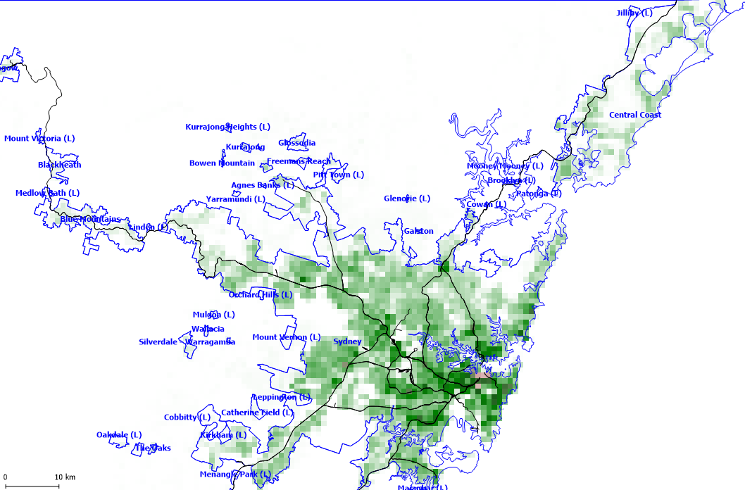
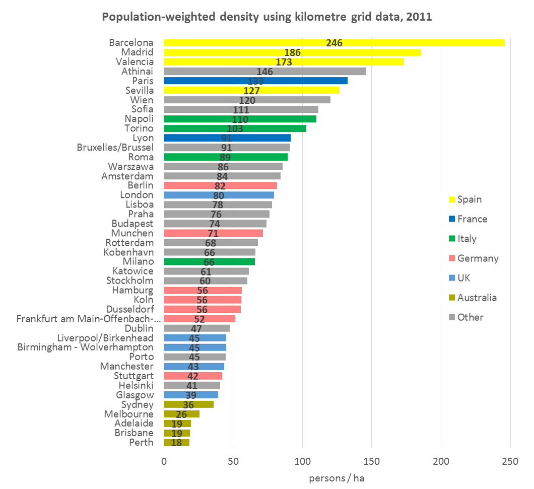
Here's a neat comparison of weighted density in European vs Australian cities. Their numbers match up to the ones I got for the few European cities I attempted to calculate the weighted densities of.
au-eu-population-weighted-density1.png

http://chartingtransport.com/2015/1...s-of-australian-and-european-cities/#comments

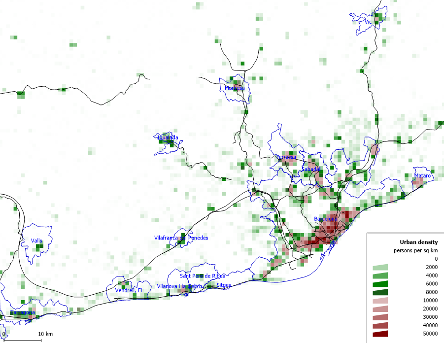
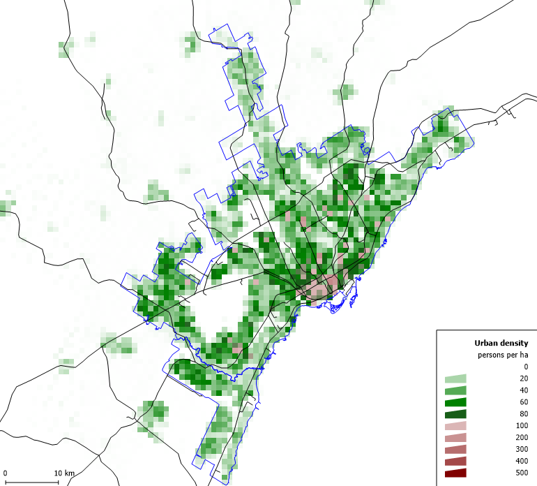
The densest European cities (pop 1m+) are Barcelona followed by Madrid, Valencia, Athens and Paris.

New York City would still rank near the top, probably somewhere a bit after Paris.

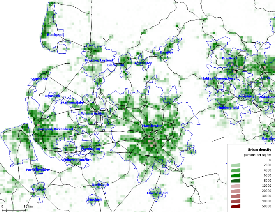
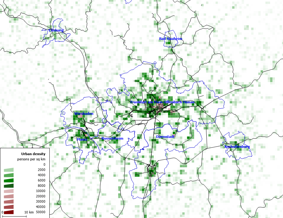
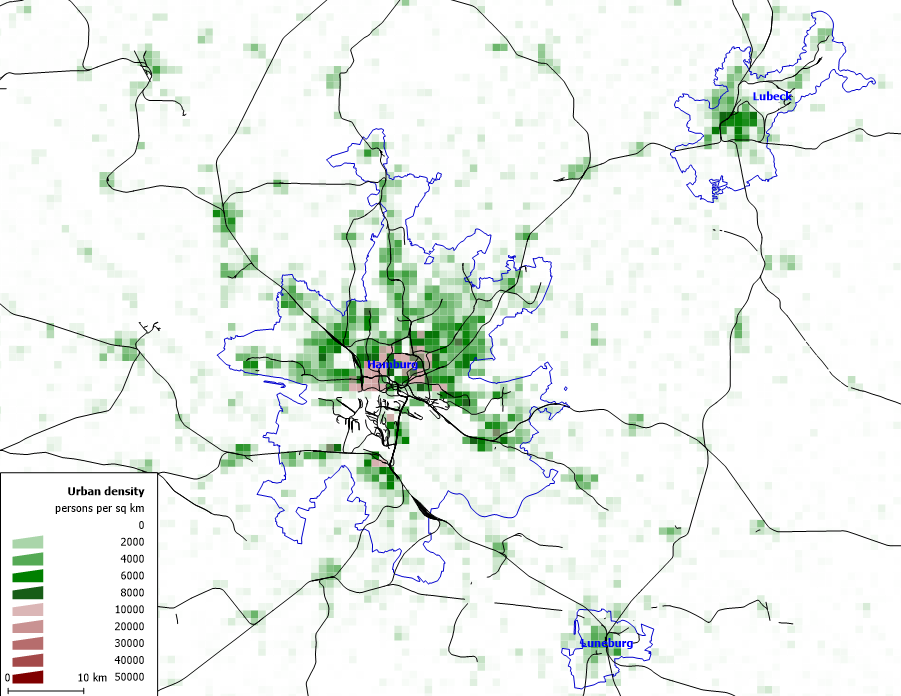
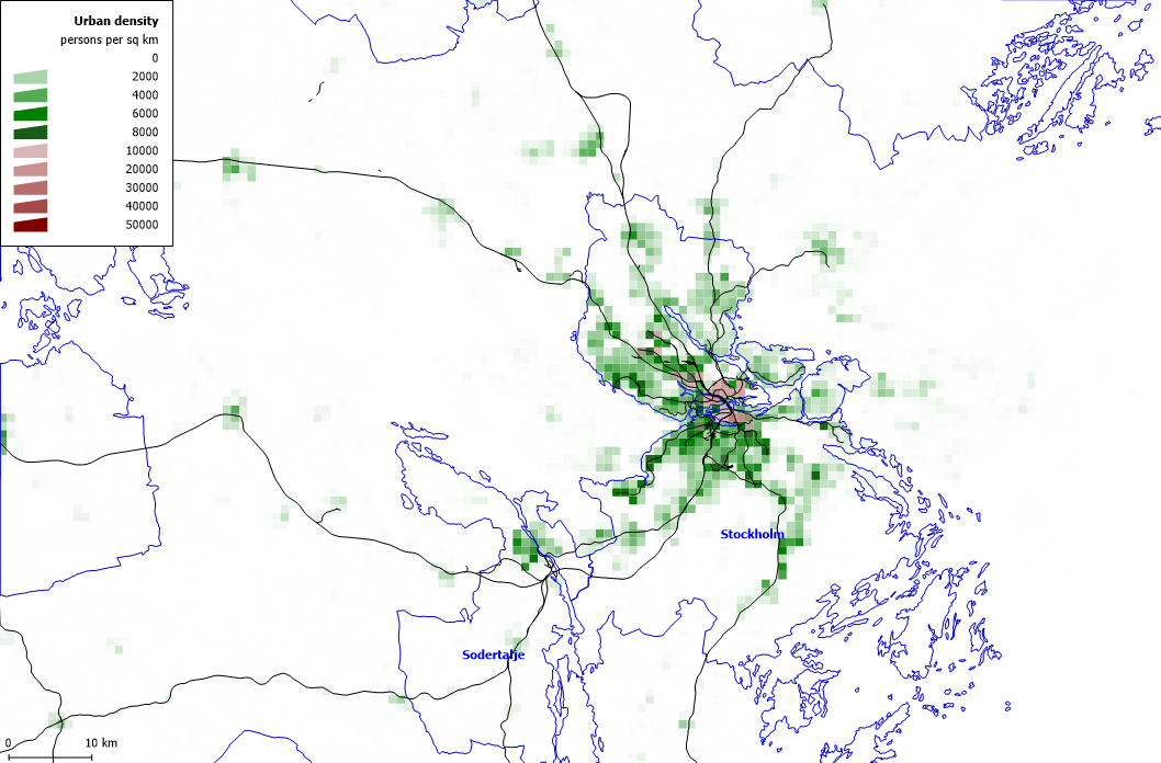
The next densest American/Canadian cities would be about comparable to the least dense European cities, mostly smaller cities in northern Europe (UK, Ireland, Sweden, Finland, Germany).

I measured weighted densities for Canadian cities, but with slightly different methodology. Toronto and Montreal would be around 50-55 pop/hectare, Vancouver around 45 pop/hectare, the next biggest Canadian cities around 25-30 pop/hectare and the smaller ones (ex Windsor, London, Saskatoon) around 15-20 pop/hectare.

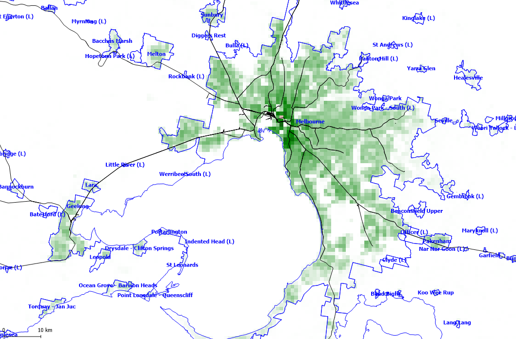
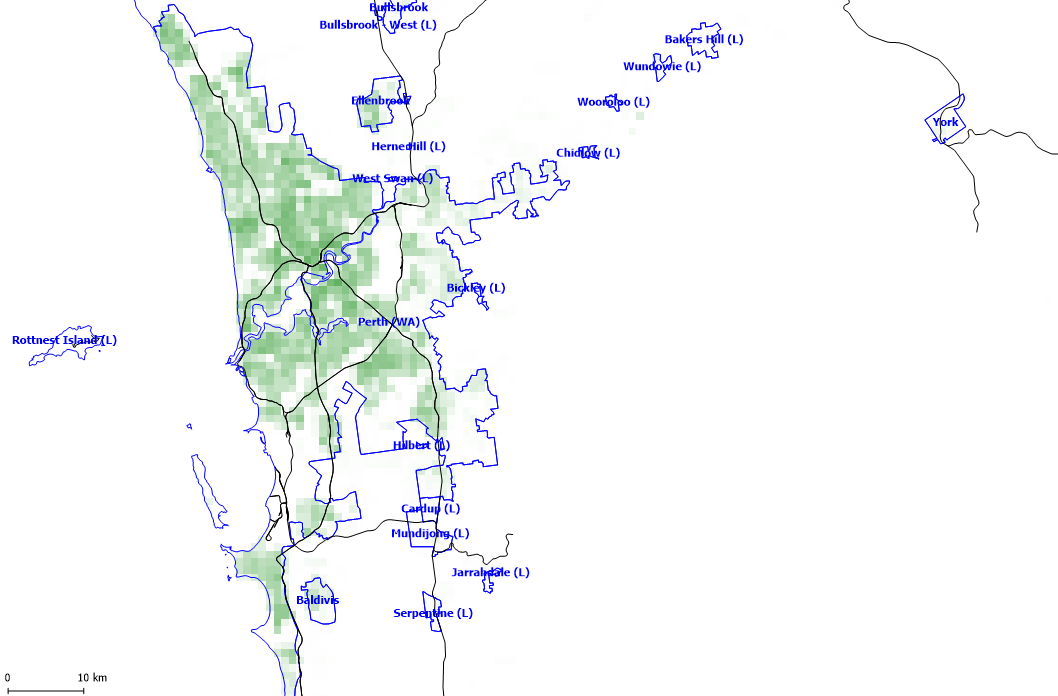
Australian cities are not especially dense. Compared to American cities, they are denser than the Southeast and many Midwestern and Great Lakes cities but no denser than Northeastern, Western/SW and South Florida. I'm pretty sure they're less "spiky" than NE cities too, but still have decently vibrant downtowns and transit use.
 
That's interesting. So, I suppose that the cities in the US, Canada and Australia still have a lot of overlap, being closer to one another in style of density than either are to Old World cities and form a grouping that is still on the "less dense" side of (developed?) cities worldwide, even if the world cities span a wide range of densities.
 
The blog post has now been updated to include Canadian and New Zealand cities. The Canadian ones were about the density I expected.

You can compare Barcelona, the densest European urban area at 24,600/km2 weighted density. Not just the core but many of the suburbs and satellite towns are fairly dense.
barcelona.png


To Toronto at 5,500/km2, where even the downtown is significantly less dense (at least in terms of residential density) than much of Barcelona and is more comparable to the density of Barcelona's satellite towns.
toronto.png


Mid-sized northern European cities like Stockholm, Dublin, Manchester, Birmingham, Helsinki and German cities like Frankfurt or Hamburg seem to be relatively similar to Toronto as well, although London and Berlin are significantly denser.

Birmingham and Liverpool, both at 4,500/km2.
liverpool-manchester.png


Frankfurt at 5,200/km2.
frankfurt.png


Hamburg at 5,600/km2.
hamburg.png


Stockholm at 6,000/km2.
stockholm.png


It's the southern European cities that are really very dense, although some of the central European cities are significantly denser than Toronto too.

Australian cities do seem significantly less dense than the big Canadian cities and for the most part more comparable to smaller Canadian cities.

Melbourne at 2,600/km2.
melbourne-3.png


Perth at 1,800/km2.
perth-3.png


Only Sydney at 3,600/km2 comes in denser than Canada's mid-sized cities like Calgary and Ottawa.
sydney-3.png
 
Weighted density only makes sense if it's population plus jobs density. If it's just population, then mixed use neighbourhoods are penalized, which makes no sense. Truly dense neighbourhoods are mixed use.
 
Amazing work! I've always wondered about the density patterns of Canadian cities vs. our international peers. I'd be curious to see a few American cities for comparison -- SF, in particular.
 
SF is pretty similar to Montreal/Toronto, perhaps slightly less dense.

The details to depend a lot upon what you include. Officially, the San Francisco-Oakland urban area has a population of only about 3.3 million people, which is a rather small fraction of the Bay Area's overall population of 8m+. That's partly because the San Francisco-Oakland MSA is a lot smaller than the Bay Area, since it excludes San Jose/Santa Clara County, as well as the North Bay communities like Vallejo, Santa Rose and Napa. Urban area boundaries can't cross MSA boundaries, so even though there's continuous development from San Francisco to San Jose, they are considered separate urban areas. And then you have all the areas that are part of the SF-Oakland MSA but are separate urban areas due to geography, like Concord/Livermore and Pittsburg/Antioch.

The boundaries for Toronto are a bit tricky too - do you include Oshawa/Whitby, Burlington, Milton... Hamilton even? But that still makes less of a difference, we're talking about a range of about 5.1 million for just the StatsCan population centre, to 6.6 million for the whole GTHA. SF-Oakland is 3.3 million vs 6.1 million if you add San Jose, Concord-Livermore, Pittsburg-Antioch and Vallejo.

This is weighted at the level of the census tract, which are typically about a km2 in size but not always. They're for the urban areas/population centres although I've also included the SF-Oakland MSA.

New York: 12,151 /km2
Toronto: 5,735 /km2
San Francisco: 5,691 /km2
Montreal: 5,455 /km2
Los Angeles: 4,843 /km2
San Francisco: 4,689 /km2 (MSA)
Vancouver: 4,669 /km2
Chicago: 3,493 /km2
Boston: 3,150 /km2
Ottawa: 2,991 /km2
Hamilton: 2,990 /km2
Winnipeg: 2,951 /km2
Miami: 2,875 /km2
DC: 2,859 /km2
Calgary: 2,791 /km2
Quebec City: 2,610 /km2
Edmonton: 2,493 /km2
Phoenix: 1,821 /km2
Houston: 1,758 /km2
Atlanta: 933 /km2
 
This is really fascinating! Thanks for posting all this great data. Mind if I ask -- how did you calculate these values? Did you write some code to do it? And what are the inputs? Are they publicly available for Canadian cities?
 
The results are interesting. I had no idea that Toronto was so comparatively dense among North American cities -- denser than a whole bunch of cities that aren't New York. For some reason I've always visualized a city like San Francisco to be far more dense than Toronto, and never knew that Winnipeg was more dense than Washington DC, or that Edmonton was more than twice as dense than Atlanta!

For some reason, I visualize most of the US cities as much bigger and more dense than they are relative to Canadian ones.
 
Saw this post as part of research for a project. After getting some data from other sources, I expanded the list a bit to include more US and Canadian cities. I cross-checked and the data from the sources is comparable.

City Weighted Population Density (ppl/sq-mi) Per hectare Per acre
Barcelona 63,714 246 100
Madrid 48,174 186 75
Valencia 44,807 173 70
Athens 37,814 146 59
Paris 34,447 133 54
Seville 32,893 127 51
New York 31,471 122 49
Vienna 31,080 120 49
Naples 28,490 110 45
Turin 26,677 103 42
Lyon 23,569 91 37
Brussels 23,569 91 37
Rome 23,051 89 36
Warsaw 22,274 86 35
Amsterdam21,756 84 34
Berlin 21,238 82 33
London 20,720 80 32
Lisbon 20,202 78 32
Prague 19,684 76 31
Budapest 19,166 74 30
Munich 18,389 71 29
Rotterdam 17,612 68 28
Copenhagen17,094 66 27
Milan 17,094 66 27
Stockholm 15,540 60 24
San Francisco 14,740 57 23
Hamburg 14,504 56 23
Cologne 14,504 56 23
Dusseldorf 14,504 56 23
Toronto 14,245 55 22
Montreal 13,468 52 21
Frankfurt am Main13,468 52 21
Wellington 12,691 49 20
Los Angeles12,543 48 20
Dublin 12,173 47 19
Vancouver 12,173 47 19
Liverpool 11,655 45 18
Birmingham11,655 45 18
Porto 11,655 45 18
Manchester11,137 43 17
Stuttgart 10,878 42 17
Helsinki 10,619 41 17
Glasgow 10,101 39 16
Sydney 9,324 36 15
Chicago 9,047 35 14
San Jose 8,766 34 14
Ottawa 8,547 33 13
Philadelphia 8,457 33 13
Boston 8,158 31 13
Calgary 8,029 31 13
Auckland 7,770 30 12
Hamilton 7,744 30 12
Winnipeg 7,643 30 12
Miami 7,446 29 12
Washington, D.C. 7,405 29 12
Edmonton 7,252 28 11
San Diego 7,186 28 11
Baltimore 6,952 27 11
Quebec City 6,760 26 11
Melbourne 6,734 26 11
Milwaukee 5,830 23 9
Saskatoon 5,686 22 9
Halifax 5,472 21 9
Christchurch 5,439 21 8
Denver 5,231 20 8
Adelaide 4,921 19 8
Brisbane 4,921 19 8
Seattle 4,747 18 7
Phoenix 4,716 18 7
Perth 4,662 18 7
Dallas-Fort Worth 4,641 18 7
Houston 4,553 18 7
Riverside-San Bernardino 4,514 17 7
Portland 4,383 17 7
Atlanta 2,416 9 4
 
Toronto is not that dense compared to many other major cities. Once you get outside of downtown Toronto it gets less dense and once in the suburbs its really not dense at all.
 
All right, after a lot of research and calculations I finally got weighted density calculations for some Asian cities. There appear to be no weighted population density calculations for Asian urban areas that are easily available based on extensive web searching, so I had to go to the raw data and calculate them myself.

Note: these weighted densities are extremely high compared to the European and North American cities on this list, but the precinct level data affirms it -- these cities really have weighted population densities of 80-100+ thousand per square mile. As I have relatives in some of those cities, I've been there myself, and it is by far the densest urban area I've ever seen.

Weighted Population Densities

Macau -- 175,195 per square mile (67,643 per square km)
Hong Kong -- 159,217 per square mile (61,474 per square km)
Singapore -- 88,051 per square mile (34,074 per square km)

Each's non-weighted population densities (around 20,000-50,000 per square mile) is already on the high end for metropolises, but then over 2/3 of HK's land is undeveloped, same with Singapore to a lesser extent, and a big part of Macau, a large gambling town near Hong Kong, is taken up by large casinos and rural land.

For Singapore, I used population and land area data from the government's 300+ census sub-zones, each of which has a median land area of about 1.23 km^2. These are essentially the equivalent of census precincts in the United States. For Macau, I used data from the five parishes of Macau Peninsula (one has a population density of 324,500 ppl per square mile!), plus data on the other Macau areas of Taipa, Coloane, and the Cotai Strip. Detailed data on Hong Kong was harder to find (the land areas of the smallest administrative areas, Teritary Planning Units, is not publicly available), so I used population and land data from HK's 18 districts, removed uninhabited areas from the density calculations, and then adjusted roughly for population variations among the inhabited areas in each district.
 
This is really fascinating! Thanks for posting all this great data. Mind if I ask -- how did you calculate these values? Did you write some code to do it? And what are the inputs? Are they publicly available for Canadian cities?
Just using census tract data. The calculations are:

[census tract % of urban area population]*[census tract density]

and then add up the values for all the census tracts

The results are interesting. I had no idea that Toronto was so comparatively dense among North American cities -- denser than a whole bunch of cities that aren't New York. For some reason I've always visualized a city like San Francisco to be far more dense than Toronto, and never knew that Winnipeg was more dense than Washington DC, or that Edmonton was more than twice as dense than Atlanta!

For some reason, I visualize most of the US cities as much bigger and more dense than they are relative to Canadian ones.
San Francisco is very dense at the core, the pre-WWII neighbourhoods within a couple km of Downtown are denser than any Toronto equivalents, however San Francisco lacks Toronto's highrise density, both in the downtown and suburbs. The more outlying parts of San Francisco proper are more like the borough of York, same with much of Oakland. But then much of the suburbs are more like Etobicoke or Pickering.

The densest pre-WWII neighbourhoods of DC are denser than Winnipeg's, but DC also has lower density streetcar suburbs like Chevy Chase, moderate density newer suburbs but also a lot of very low density post-WWII suburbs. Winnipeg is mostly moderately high density urban core and moderately low density post-WWII suburbs (but less post-WWII development compared to DC).

Atlanta as well as other southeast cities are mostly ultra low density suburbs and leapfrog development. Even their cores are basically like Richmond Hill or Central Etobicoke in terms of density.
 
Last edited:
Toronto is more compact than Montreal? Yet, Montreal has a better bicycle network than Toronto.
I'm not sure if bicycle networks have that much to do with density. But anyways, Montreal's core is denser than Toronto's by and large, the difference is that the suburbs are less dense.

Here's a couple maps comparing the two. These aren't census tracts though, mostly they're 2-5 adjacent census tracts combined together (lets call them neighbourhoods), and it's not exactly the urban area either but just adjacent neighbourhoods that are over 200 people/km2 (although Hamilton's excluded).
eDNeAXD.jpg

F5rBSxV.png

Density in pop/km2

White = 200-1000
Gray = 1000-2000
Blue = 2000-3000
Green = 3000-4000
Yellow = 4000-5000
Yellow-Orange = 5000-6000
Orange = 6000-7000
Red = 7000-8000
Maroon = 8000-10000
Purple = 10000-15000
Black = 15000+
 
Last edited:
All right, after a lot of research and calculations I finally got weighted density calculations for some Asian cities. There appear to be no weighted population density calculations for Asian urban areas that are easily available based on extensive web searching, so I had to go to the raw data and calculate them myself.

Note: these weighted densities are extremely high compared to the European and North American cities on this list, but the precinct level data affirms it -- these cities really have weighted population densities of 80-100+ thousand per square mile. As I have relatives in some of those cities, I've been there myself, and it is by far the densest urban area I've ever seen.

Weighted Population Densities

Macau -- 175,195 per square mile (67,643 per square km)
Hong Kong -- 159,217 per square mile (61,474 per square km)
Singapore -- 88,051 per square mile (34,074 per square km)

Each's non-weighted population densities (around 20,000-50,000 per square mile) is already on the high end for metropolises, but then over 2/3 of HK's land is undeveloped, same with Singapore to a lesser extent, and a big part of Macau, a large gambling town near Hong Kong, is taken up by large casinos and rural land.

For Singapore, I used population and land area data from the government's 300+ census sub-zones, each of which has a median land area of about 1.23 km^2. These are essentially the equivalent of census precincts in the United States. For Macau, I used data from the five parishes of Macau Peninsula (one has a population density of 324,500 ppl per square mile!), plus data on the other Macau areas of Taipa, Coloane, and the Cotai Strip. Detailed data on Hong Kong was harder to find (the land areas of the smallest administrative areas, Teritary Planning Units, is not publicly available), so I used population and land data from HK's 18 districts, removed uninhabited areas from the density calculations, and then adjusted roughly for population variations among the inhabited areas in each district.
What's the average (or median) land area and population for each of the units of measurement for those cities? Their size can have a fairly big impact on the final values. For census tracts, they're usually about 4000 people each. However, I think for Toronto if you used dissemination areas (roughly equivalent to US block groups) of about 600 people each vs the larger ~20,000 person "neighbourhoods" from the map in my previous post, there would be an almost 2-fold density difference.
 

Back
Top