News   Mar 09, 2026
 1.4K     5 
News   Mar 09, 2026
 330     0 
News   Mar 09, 2026
 2K     7 

Toronto Eglinton Line 5 | ?m | ?s | Metrolinx | Arcadis

Catching up on the outcome of this week's Council meeting, I found an interesting amendment that was passed, but didn't get a lot of buzz in the media

http://app.toronto.ca/tmmis/viewAgendaItemHistory.do?item=2016.EX13.3

3 - Motion to Amend Item (Additional) moved by Councillor Stephen Holyday (Carried)
That City Council direct to the Chief Planner and Executive Director, City Planning to commence a comprehensive planning framework review for the Eglinton Avenue West corridor from Mount Dennis to the Etobicoke Creek to articulate the future of this linear tract and catchment area, along with an integrated approach to the community's long term vision, such review will:

a. build upon and extend the work of Eglinton Connects and the Mount Dennis Nodal Study, and better inform land use, transportation and transit planning with an aim to define specific future growth potential;

b. include, but not be limited to, Official Plan designations, zoning bylaws, Avenue overlays where they exist, a market feasibility study, nodal opportunities, roads, infrastructure and public realm associated with transit and transportation infrastructure investments, and an enhanced public communication and consultation process; and

c. incorporate Eglinton Avenue West itself, and significant points of potential such as plazas, apartment lands infill sites, and under-utilized sites within 750 metres of transit along the avenue.

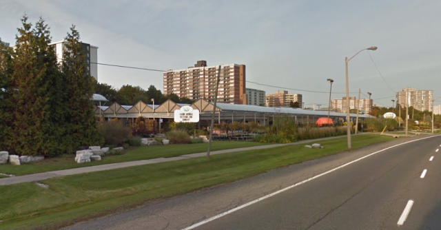
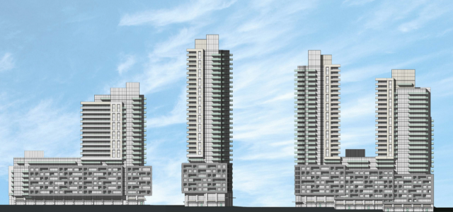
Looks like some of the complaints about how the Eglinton corridor had been sold out from under us got some attention with at least some councillors.

- Paul
 
There were suggestions that the Mulham stop (between Royal York Road and Scarlett Road), which would have served Plant World, be dropped.


However, there comes news (see link) of a possible five-tower development on the Plant World site.
14

20354-69442.png


See this link and link for more information.

20360-69437.png


20354-69443.png


What this means is that a light rail stop might be needed at Mulham to better serve the area, not just for the existing high and medium residences, but also the future residences (1,900 units for 4000 Eglinton Avenue West), or even more.

20354-69446.png
 
Last edited:
There were suggestions that the Mulham stop (between Royal York Road and Scarlett Road), which would have served Plant World, be dropped.
This is going to be above ground. I really don't see why we shouldn't have stops at Widdicombe, Wincott, Russel and Mulham. Dropping these stations is not going to make the trip much faster.
 
I really don't see why we shouldn't have stops at Widdicombe, Wincott, Russel and Mulham. Dropping these stations is not going to make the trip much faster.

This is a slippery slope. I do suspect that whatever traffic control and left-turn accommodation is designed will have more impact on speed than a couple more stops. All the more reason why we need to look at this on an integrated basis, and not in isolation.

There is no absolute threshold where we shrug and say "OK, it's a street car not an LRT" - but if that's what results, good luck getting taxpayer support for any further LRT lines in the city. We have to get this one (and Finch, and Hurontario, and Eglinton East) right.

- Paul
Yah, but this is not St. Clair streetcar stop intervals.

Including those above stops means stopping every 500m rather than 1km. Look at Google Maps. All those stops are also the only access points to the neighbourhoods to the north and south of Eglinton.
 
I thought the LA Metro LRT lines were pretty well done. They seemed more heavy on the grade separation than Toronto has planned.
 
All those stops are also the only access points to the neighbourhoods to the north and south of Eglinton.

I'm not optimistic that we will pull much ridership out of those curvy suburban streets, it's not very dense. Although it would be an interesting place to try some jitney-style local bus service. I saw some pretty funky little buses in Italy, many of them battery powered.

If Eglinton were being developed properly, to be a pedestrian-oriented livable street, there might be a need for those stops. The crappy town homes and the towers that you pointed out may go in at Plant World don't inspire that. People will get in their cars in the underground garage, and drive to the mall. The ridership will consist of people transferring to north-south routes at the main intersections.

- Paul
 
There's also the argument that people have no idea where Museum, Queen's Park, St Patrick, Osgoode and St Andrew stations are located. Even names like Old Mill, Christie, Chester, Donlands and Main Street aren't name after well known streets.
but chester is still a street as is christie, old mills, donlands, main street 0- it does not matter if they are not well known - they are obviously known to people living in the east end
 
but chester is still a street as is christie, old mills, donlands, main street 0- it does not matter if they are not well known - they are obviously known to people living in the east end
My point is people will get use to these Metrolinx names and it would sound less strange.
 
FYI.

From this link, the plans for a heavy rail Eglinton West subway included these stations:

Eglinton_West_Line.png


At minimum, the light rail stops, west of "York Centre" now Mt. Dennis, should have stops at the proposed stations.

Roughly equal to the intersections of old proposed "Richview Expressway.

Richview_Expwy..png
so basically the majority of the heavy rail was to be basically where above surface LRT stops are to be now in the west end
 
I thought the LA Metro LRT lines were pretty well done. They seemed more heavy on the grade separation than Toronto has planned.

Nice if the federal government (that the U.S. government for LA) helps pay for almost half the capital costs vs 1/3 for Toronto. See link.

Marking an historic vote of confidence in Metro Rail subway construction in Los Angeles, the L.A. County Metropolitan Transportation Authority (Metro) today joined federal, state and local elected officials to announce the receipt of a $1.25 billion Full Funding Grant Agreement (FFGA) from the Federal Transit Administration to help pay for the first nearly four-mile, $2.821 billion segment of the long-awaited Metro Purple Line Extension Project toward West Los Angeles.
 
My point is people will get use to these Metrolinx names and it would sound less strange.
i do not believe it. People will say get off at Cederville forgetting on the subway its eglinton west as an example. The names do need to be change so it reflects the cross street. If people are complaining that no one knows where Osgood or St patrick is then why do it with these new stops on the Crosstown. I do need to add for people working downtown they do as they go by the subway stops everyday
 
I think Cedarville is stupid because it should just be called Eglinton West station. It is the interchange station for Christ sake.

The others (minus Hakimi Lebovic, which will always be stupid) I think we will get used to over time.
 
Nice if the federal government (that the U.S. government for LA) helps pay for almost half the capital costs vs 1/3 for Toronto.
I don't think the federal government has ever paid for any of the capital costs in Toronto, until the recent Harper government did so on the Spadina extension.
 
  • Like
Reactions: rbt

Back
Top