News   May 14, 2024
 1.7K     1 
News   May 14, 2024
 1.4K     1 
News   May 14, 2024
 604     0 

Waterfront: General Topics

of course. Let's face it - Democracy is a horrible thing for cities. Imagine Paris if Haussmann wasn't given free-reign. I mean ya it sucked for the people it affected at the time, but that's such short-sightedness, and the city benefits exponentially today from those changes.

It's mostly a timescale problem, which is unfortunate. Consider the fact that much of the New York subway is over 100 years old, and the London Underground 140. Those up-front infrastructure investments have been paying off for a century+, and with reasonable maintenance (OK, a lot of maintenance, in London's case) will continue to do so indefinitely. Sadly, 4-year electoral terms and annual budgeting rarely reflect this...

This is what bugs me so much about Transit City, if I may go slightly off-topic. We are going to spend a huge amount of money to get infrastructure that's not very durable. It's highly unlikely that any future generations are going to look back and thank the Lord that Adam Giambrone and David Miller had the vision and foresight to put streetcars on Sheppard.

All this is to say that I hope we do things really, really right on the waterfront, and give the city a lasting positive legacy there.
 
Last edited:
This is what bugs me so much about Transit City, if I may go slightly off-topic. We are going to spend a huge amount of money to get infrastructure that's not very durable. It's highly unlikely that any future generations are going to look back and thank the Lord that Adam Giambrone and David Miller had the vision and foresight to put streetcars on Sheppard.

The funny thing is that there is something very authoritarian and undemocratic about how Giambrone, Miller and Steve Munro foisted Transit City upon us; how they cooked the books to make subways seem fantastically out of reach; how they deliberately ignored any transit mode choice other than LRT; how the routes seemed to arbitrarily be drawn on a map of the city like pen lines on a napkin; how the city conveniently expedited the environmental assessment review process in time for Transit City project to move forward.

It is the biggest transit scam in this city's history and a generation from now, when we are saddled with this $10 billion monument to collective mediocrity, Miller et. al will go down like Moses (Robert Moses, that is).
 
I really don't understand why transit city doesn't include the
Harbor front east compontent ... isn't that already in the planning?
 
I thought it was part of the planning and one of the reasons behind the Union Station streetcar platform reno. Maybe it just isn't part of transit city, like the Fort York/Bremner blvd ROW is excluded.

100,000 residents are supposed to live in this area without access to higher order public transit? That is outrageous and will only spur a car-dependent neighbourhood. Parts of Transit City can go forward but others options need to be amended or added.
 
Last edited:
I'm not sure where to put this, as there is no Harbourfront in the neighbourhood section. I saw this being built at Harbourfront the other day. Does anybody know what it is or what it will be used for?

DOWNTOWNEASTEND-April29-09032.jpg
 
I was going to post about it too. They went and dug up the lawn last week and that was in place merely days later. It was a very fast transformation. I tried going on the harbourfront centre website, but couldn't find anything about it. The only thing myself and my girlfriend could think of was a larger market area, but who knows.
 
I really don't understand why transit city doesn't include the
Harbor front east compontent ... isn't that already in the planning?
Apparently it is being build separately from Transit City.

The only thing I don't understand at all is the fact that Cherry St. will be using only the new streetcars on it because there aren't enough old ones for a new route.

What I think would be a great idea is for the new streetcars to be the same type as the Transit City cars, which have the capacity to turn around like subway trains, without a loop. Then we can start rebuilding our old streetcar lines to make them more modern, but the new cars will still be able to run on them even before the track changes have taken place. This would be a great first step to modernizing our Light Rail system and I think it would make the whole system a lot smoother.
 
I really don't understand why transit city doesn't include the
Harbor front east compontent ... isn't that already in the planning?

All transit on the Waterfront is been done under the Waterfront development.

The plan has been decided that transit will run on the south side of the Queens Quay from west of Spadina to a new Cherry street in the east.

Traffic will be 1 lane in each direction on the north side of transit with 150 parking spots at various spots in the westbound lane.

What you see on QQ will disappear starting the fall of 2010.

A new portal will replace the existing one as the new one will allow through service as well servicing Union Station from both direction.

LRT will be on Cherry St as well 3 other east-west lines in the portlands area.

Grass will be place between the tracks.

The Cental section/existing section has to be finish by fall of 2011 or spring 2012 to be ready for the War of 1812 events as well the arrival of the Tall Ships
 
Apparently it is being build separately from Transit City.

The only thing I don't understand at all is the fact that Cherry St. will be using only the new streetcars on it because there aren't enough old ones for a new route.

What I think would be a great idea is for the new streetcars to be the same type as the Transit City cars, which have the capacity to turn around like subway trains, without a loop. Then we can start rebuilding our old streetcar lines to make them more modern, but the new cars will still be able to run on them even before the track changes have taken place. This would be a great first step to modernizing our Light Rail system and I think it would make the whole system a lot smoother.

The New LRT's were supposed to be here now and will be on the rebuilt Queens Quay when transit is put back into service in 2011/12. The plan was to use the new LRT's to be the show case for the Waterfront selling point.

The exiting track replacement work was supposed to happen in 2008, but with the redisgn, it will start fall 2010.

There will be a loop just west of Cherry St until a new Cherry St underpass is built to allow connection to it as well the Lower Don (River City)
 
http://www.toronto.ca/waterfront/pdf/public_meeting_and_cag_final.pdf

I just noticed that the final Western Waterfront Master Plan Public Open House and Meeting met in February and I missed it. Since I noticed they're having meetings to discuss the plan for the western waterfront last fall I've been thinking I need to attend.

I totally approve of their plans to straighten Lake Shore to allow more space between the boulevard and the lake.

They also want to re-establish some beaches a bit further to the east and move parking to the inland side of Lakeshore.

The plans do include reference to the waterfront LRT which would extend the existing exhibition streetcar.

The main thing I feel strongly about, which they only hint at in the presentation, is the inclusion of retail (shops and restaurants). Introducing retail, I think, would bring Sunnyside back to its' pre-Gardiner Expressway roots as an entertainment area. It would be a way to turn the massive amount of automobile traffic through the area into an asset. Trying to move things around and plant trees to minimize the impact of cars seems to me a losing battle. But the area would have some appeal if there were throngs of people sitting on patios overlooking the boardwalk.
 
Looks like a really awesome plan. If they could turn the area into a sort of 'The Beach' west that would be awesome. I realize that Queen street is not so nearby, but with the inclusion of shops and retail perhaps that would be possible. I wonder if there is any space along lakeshore between it and the Gardiner to have any retail strip.
 
Toronto's beaches are now open for the summer, so I took a walk over to check them out. Not much change from last year. (this is the western beaches) The last one in the water, is a "rotten egg". lol

westwaterfront2june9091.jpg

By torontovibe, shot with DSC-N1 at 2009-06-11

WESTWATERFRONT2--June9-09205.jpg


TorontosWesternBeaches1.jpg


TORONTOSWESTERNBEACHES-ReadyForSumm.jpg
 
Last edited:
‘Worst waterfront in the world’ to be transformed by 2012

City planners won praise from area residents for a plan to transform the Downtown waterfront—once voted one of worst in the world—into one of the 10 best.

More than 300 Queen’s Quay neighbourhood residents liked what they heard at the presentation by Waterfront Toronto, the city and the Toronto Transit Commission. It was the latest round of consultation required for Queen’s Quay Revitalization and the East Bayfront Transit environmental assessments.

Chris Glaisek, vice president of planning and design for Waterfront Toronto, said the project will use the example of a past international Hall of Shame award given to the Toronto's waterfront and make it into a Hall of Fame location.

“There was a ranking done by the Project for Public Space, an international body that looks at cities all around the world,†said Glaisek. “They rate the best and worse in a whole lot of categories including waterfronts.

“Toronto's waterfront and photos were all of Queen’s Quay and was listed in the Hall of Shame as the Project for Public Space's 10 worse waterfronts in the world. We want that to change. We want this to be one of the 10 most beautiful.â€

There was little concern or argument as Queen’s Quay residents and area associations voiced their pleasure in being key participants in the development and design of Toronto's waterfront.

Work on one of the two preferred $350 million proposals is scheduled to begin in 2010, completed in 2012.

The final decision on the proposals will be made September 2009.

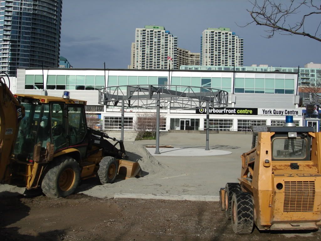
Construction will transform the eastbound traffic lanes into wide, tree-lined, pedestrian-friendly thoroughfares. Both plans will move all vehicle traffic north of the streetcar tracks. The more popular proposal is a 2-way traffic design while the other plan is for a 1-way west-bound lane. There will also be a succession of parking aisles on the north side for short-term parking. The TTC streetcar underground portal will be relocated from its current location on Queen’s Quay, east of Bay, to rest between Cooper St. and Freeland to complement pedestrian traffic.

A few concerns voiced by residents and business owners included having enough public washrooms in addition to bus lines having comfortable access to parking to bring in the much needed tourists that sustain many of the waterfront businesses.

However, most of those attending the meeting had high praise for the work Waterfront Toronto has put into the project as well as time taken in listening to the public. More than 40 consultation meetings have been held over the last 18 months.

“I have to compliment Waterfront Toronto on incredible public process and all the consultations that they've done,†stated Pam Mazza, representative from the Toronto Island Community Association, echoing many of the comments heard that night. “It's been splendid and we are all extremely excited about the proposals for Queens Quay. Thank you, Waterfront Toronto team—you've been fantastic.â€

http://thebulletin.ca/cbulletin/con...2137555725230571714&ctid=1000006&cnid=1002129
 

Back
Top