News   Apr 26, 2024
 1K     4 
News   Apr 26, 2024
 289     0 
News   Apr 26, 2024
 817     0 

TTC Cartography, Signage, and Wayfinding

The maps on the Rocket trains have the Allen Rd section align mostly correctly with Dufferin:

View attachment 43052

And the Vaughan extension already has the hardware in place. You can see that it will run diagonally, and roughly line up with Jane on the Bloor line:

View attachment 43053

Good. This is much better than the "stick-on" Downsview extension that they put on the late 1980s maps back in 1996. Those lingered until a new version was created just before the Sheppard line opened. It had the station names in the same colour as the lines, which made for some challenging reading, especially when they continued it when Sheppard opened. That version was quickly replaced by one with white letters.
 
Horrible.
subway01.gif
 

Attachments

  • subway01.gif
    subway01.gif
    70.9 KB · Views: 1,134
The maps on the Rocket trains have the Allen Rd section align mostly correctly with Dufferin:

View attachment 43052

And the Vaughan extension already has the hardware in place. You can see that it will run diagonally, and roughly line up with Jane on the Bloor line:

View attachment 43053

For Dufferin, can we say wishful thinking much? :p

Interesting about the Vaughan extension though I actually saw those spots ready to go on one of the first TRs I ever rode, two years ago, when the map was in a similarly incomplete state. Still, it boggles my mind why the TTC went with such a difficult-to-modify system for the TR map, where the existing map (+/- a few extra dots) is physically hard-wired in. The LCD screens which can update dynamically make so much more sense.
 
For Dufferin, can we say wishful thinking much? :p
How so?

They have the Allen Rd section diagrammatically represented as a vertical line (which is close enough to reality), and it is positioned slightly to the east of Dufferin on the Bloor line (which is also close enough to reality). In the realm of diagrammatic maps, it seems pretty reasonable.
 
Hasn't the current downtown boom only happened in the past decade or two?
Sure, but there have been other booms before it. Practically all of the skyscrapers downtown, including the bank towers, were built post-1965. Downtown is vastly larger and more populated than it was 50 years ago; it's barely the same place.

Besides, even if the current boom were the only growth in the last 50 years, it's pretty damning that it would take a decade or two to just start planning for subway expansion. The seeds for the current boom were planted in the 1990s; that's when planning for the DRL should have started.
 
Downtown has the same rapid transit system it had 50 years ago. That's just sad.

It is very sad. The Queen Subway was supposed to be next in line after the first leg of Yonge was completed in '54. Basically every project since came at the expense of this critical and strategically significant line. As well, almost every project came with the expectation that downtown surface ridership would stagnate, or somehow be offset by new growth well outside of downtown.

Let's Move (no Queen Subway/RL); MoveOntario2020 (no Queen Subway/RL); Transit City (no Queen Subway/RL); Big Move (an abridged afterthought "25-year plan" Queen Subway/RL at #48, to be built long after Vaughan ext, Yonge North, and Crosstown opened). Seemingly the only plan where we could've seen some action was Network 2011 three decades ago. But that was for ICTS, and it would've been built above the rail corridor and only skirted our financial district.

Whereas most major cities strengthen their CBD and invest in it, Toronto seems to be one of the few that tries to deprive/starve their core by diverting major infrastructure funding for the creation of new, suburban "Centres" across the city. And in recent years, allowing for Centres outside of the city (e.g VMC and soon RHC). Fortunately our population targets are exactly where anti-Old Toronto planners expected it'd be; unfortunately much of it is located nowhere they expected it'd be. And while the former boroughs and 905 get shiny new RT infrastructure; our thronging downtown that has defied the odds gets...I dunno, new homeless shelters, to add on to the multitude of shelters already crammed in there.
 
A big problem is you have idiotic politicians like Rob Ford who pit downtown against the suburbs so proposing anything downtown is seen as being unfair to the suburbs and nothing gets built.
 
How so?

They have the Allen Rd section diagrammatically represented as a vertical line (which is close enough to reality), and it is positioned slightly to the east of Dufferin on the Bloor line (which is also close enough to reality). In the realm of diagrammatic maps, it seems pretty reasonable.

I was making a joke in reference to the fairly commonly-accepted sentiment that the Spadina line would have been far more successful had it (and thus should have) been run up Dufferin rather than the median of Allen Road.
 
It is very sad. The Queen Subway was supposed to be next in line after the first leg of Yonge was completed in ’54. Basically every project since came at the expense of this critical and strategically significant line. As well, almost every project came with the expectation that downtown surface ridership would stagnate, or somehow be offset by new growth well outside of downtown.

Let’s Move (no Queen Subway/RL); MoveOntario2020 (no Queen Subway/RL); Transit City (no Queen Subway/RL); Big Move (an abridged afterthought ’25-year plan’ Queen Subway/RL at #48, to be built long after Vaughan ext, Yonge North, and Crosstown opened). Seemingly the only plan where we could’ve seen some action was Network 2011 three decades ago. But that was for ICTS, and it would’ve been built above the rail corridor and only skirted our financial district.

Whereas most major cities strengthen their CBD and invest in it, Toronto seems to be one of the few that tries to deprive/starve their core by diverting major infrastructure funding for the creation of new, suburban “Centres†across the city. And in recent years, allowing for Centres outside of the city (e.g VMC and soon RHC). Fortunately our population targets are exactly where anti-Old Toronto planners expected it’d be; unfortunately much of it is located nowhere they expected it’d be. And while the former boroughs and 905 get shiny new RT infrastructure; our thronging downtown that has defied the odds gets...I dunno, new homeless shelters, to add on to the multitude of shelters already crammed in there.

What makes it more bizarre was the that the old City seemed to be totally in favour of the creation of the suburban Metro cores and was dead set against the Queen Subway/RL and further densification of the core. It was like "our downtown is big enough now, and we like it that way, so go somewhere else like North York Centre or Scarborough Centre". Was this a holdover of an "anti-high density" mentality? Of course the transit planning was geared to that ... the Scarborough LRT, the Sheppard Subway connecting North York Centre to Scarborough, the Eglinton West subway. The City of Toronto planners seeme to be complicit in this scheme, not just some "anti-Toronto planners".
 
What makes it more bizarre was the that the old City seemed to be totally in favour of the creation of the suburban Metro cores and was dead set against the Queen Subway/RL and further densification of the core. It was like "our downtown is big enough now, and we like it that way, so go somewhere else like North York Centre or Scarborough Centre". Was this a holdover of an "anti-high density" mentality? Of course the transit planning was geared to that ... the Scarborough LRT, the Sheppard Subway connecting North York Centre to Scarborough, the Eglinton West subway. The City of Toronto planners seeme to be complicit in this scheme, not just some "anti-Toronto planners".

With the construction of the Yonge, University, and Bloor subways, as well as the Don Valley Parkway, a huge amount of transportation capacity was opened up to downtown. Through the '60s and '70s, it started seeing huge mega-developments that were razing huge swaths of downtown. The financial district was toppling its old buildings to build the new modernist (a.k.a. sterile) office buildings. The St. Lawrence and King west areas were flattened for parking lots. St. James Town and Regent Park bulldozed huge areas of low-rise housing in the name of towers in the park. The Eaton Centre "ruined" the active street life of Yonge St, and even New City Hall and Nathan Philips Square were built with great controversy, as the plan had been to demolish Old City Hall.

When that's the kind of development you see after a new subway comes to town, it's not hard to see why downtown actively fought against a Queen subway that would have opened up even more land to this kind of block-busting.

Development was not always as comparatively positive as it is today.
 
Last edited:
With the construction of the Yonge, University, and Bloor subways, as well as the Don Valley Parkway, a huge amount of transportation capacity was opened up to downtown. Through the '60s and '70s, it started seeing huge mega-developments that were razing huge swaths of downtown. The financial district was toppling its old buildings to build the new modernist (a.k.a. sterile) office buildings. The St. Lawrence and King west areas were flattened for parking lots. St. James Town and Regent Park bulldozed huge areas of low-rise housing in the name of towers in the park. The Eaton Centre "ruined" the active street life of Yonge St, and even New City Hall and Nathan Philips Square were built with great controversy, as the plan had been to demolish Old City Hall.

When that's the kind of development you see after a new subway comes to town, it's not hard to see why downtown actively fought against a Queen subway that would have opened up even more land to this kind of block-busting.

Development was not always as comparatively positive as it is today.

I suppose this is part of the reason why there was so much opposition to the DRL from downtown residents back in the 1980s.
 
What makes it more bizarre was the that the old City seemed to be totally in favour of the creation of the suburban Metro cores and was dead set against the Queen Subway/RL and further densification of the core. It was like "our downtown is big enough now, and we like it that way, so go somewhere else like North York Centre or Scarborough Centre". Was this a holdover of an "anti-high density" mentality? Of course the transit planning was geared to that ... the Scarborough LRT, the Sheppard Subway connecting North York Centre to Scarborough, the Eglinton West subway. The City of Toronto planners seeme to be complicit in this scheme, not just some "anti-Toronto planners".

That’s definitely true, particularly with Jack Layton et al. But the way I see it is that there’s always opposition to higher density at the local level – regardless of whether it’s downtown or, say, North York. There’s generally a unanimous consensus amongst people to not want condos popping up in their backyards, or new traffic clogging up their streets.

It’s true there was organized resistance to downtown development at some points in our history. But the Queen Subway should’ve still been recognized/prioritized - despite intermittent opposition, or the preposterous notion that high density growth in the core would somehow cease. The line is too important from a network perspective. As well, our planners should’ve foreseen that opposition to high density didn’t and couldn’t do much to stop the growth. They also should’ve acknowledged that mass transit is about more than just making tall buildings sprout from the ground.

The way the Metro government was organized, the TTC, and the current Megacity - downtown had/has little representation. The suburban voice is the dominant one in this city. And just as our planners should’ve seen past local level opposition to high-density growth, they also should’ve seen past political grandstanding for suburban pet projects. Or at the very least done a better job acknowledging that some of the logic behind suburban CBD “Centres†can be flawed/unreliable, and that using scarce/finite capital on the most expensive transit option may not be sensible.

As well, political underrepresentation shouldn’t really make all that much difference for a crucial line like a Queen Subway. Sure, residents along the surface routes through the core probably complained to their councillors about the cattle car conditions and slow service of the streetcars. But seemingly the majority of existing surface transit riders (and potential new subway riders) through the core are non-local commuters. That’s not really a local councillor’s jurisdiction to deal with. And even if it was supposed to be their purview, the amount of non-transportation issues specific to downtown that were arguably more pressing to them would’ve rendered something like a monumental and daunting new subway line somewhat of a non-priority backburner problem. Yes, councillors like Adam Vaughan and Pam McConnell could’ve used their office budgets to study a subway on their own – which they then could’ve presented to the other 43 members of Council or TTC board. But that wouldn't have made sense. Our planners should’ve understood there wasn’t enough political pull for the Queen Subway/RL to become a “priority†from a very small group of downtown councillors.

So, yeah. I guess it’s improper for me to lay the blame at “anti-Old Toronto plannersâ€. Clearly politics and politicians (from both Old Toronto and the suburbs) infiltrated and dictated planning direction, transportation infrastructure spending, and TTC governance. And that for the most part things are generally backwards here. So I guess right, left, downtown, suburban...everyone is at least partially to blame *shakes fist in discontent*.
 
Re earlier discussion about this topic related to UPX and anticipation of the Pan Am games -

While at Pearson today I poked around to look at the signage. My POV was not so much geared to the average Torontonian, but whether a tired and frazzled air traveller who has never been to Toronto before can easily find the city bus. Here's my less than positive review:

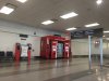
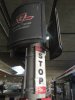
First of all, incoming travellers have to find the city bus platform. Here's the area around the doorway - the last heated/air conditioned/lighted point before leaving the building. You want the incoming traveller to breathe a sigh of relief and say "Whew...we made it". Does this cry "You have found the city bus!" ? At least you know you can buy a Coke and a sandwich so you won't starve if you are stranded without a bus!

This is where travellers most need good information, but there is no TTC route map, nor is there any mention of GO, BT, or Miway - other than the overhead sign, which displays only their corporate logo, which the traveller from afar won't recognize.

The TTC dispensers don't sell individual tokens - I sold a woman one out of pure sympathy. And the machines are not well marked, you wouldn't immediately conclude that you should stop and buy a token before heading out to the platforms. Why is there no "BUY CITY BUS TICKET HERE" sign?

Lastly, while all the TTC signage is regulation, the whole thing has no visual focus especially when placed next to that monstrous Coke machine. The first rule of graphics presentation is - consider your presentation within the wider context. The TTC signage should be larger than the Coke machine's.

IMG_0193.jpg


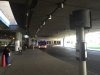
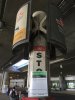
Now look at what travellers find when they go out onto the bus platform. It's very dark - my iPhone actually improved the scene over the naked eye. None of the signage is illuminated. The GTAA standard graphics for the specific service - BT in this case - has a tiny font. GO and TTC have larger signs - the white TTC sign is visible - but these only have the corporate logo, which means nothing to someone from afar. GTAA needs to get serious about helping the transit agencies say "Here we are!".

IMG_0196.jpg


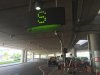
The designation of area S as the place you find Public Transit is dumb - it's actually down at the end of the platform, and it's really badly lit. Nowhere in the Airport Terminal did I find a sign that said "Looking for the public transit? Proceed to Area S". It's totally irrelevant. Why was it installed?

IMG_0195.jpg


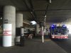
Looking closer at the TTC area, which has had the most thought and effort put into it - the route map is next to a garbage can, discouraging close up viewing. The map belongs back indoors, where people figure out their next step and buy their tickets and maybe ask for help...and where it's warm and quiet. The frazzled arrival doesn't need to be out here in the cold wind, trying to talk over the traffic and plane noise.

IMG_0197.jpg


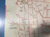
Note that the route map is filthy. And unlit. Most importantly, there is no "YOU ARE HERE" dot on the map. A lot of TTC route mappage on the system lacks this. To anyone navigating an unfamiliar city for the first time, this is the most important bit of information on a map. TTC signage policy should put one on every map they display.

As for the other properties, why do they have none of this? Anyone looking for BT or Miway needs all the same supporting information.

IMG_0199.jpg


It looks like TTC policy has prevailed with respect to the stop itself - it's the standard TTC logo for stop, and it's pretty self explanatory. A little clearer signage that points to the 192 Rocket - "BUS TO TORONTO SUBWAY" - would be better. How you explain the 52 Lawrence route, I don't know. I like large capital letters for signs, and the universal logos would help too. Again, that familiar TTC winged logo is great for us locals, but means nothing (yet) to the new visitor.

IMG_0198.jpg


My last complaint is the temporary route information that has been tied to the sign. This is standard TTC practice, but it blocks much of the sign. And it looks crappy. (At least they didn't use duct tape). TTC needs to revise their standard bus stop pole and sign to have a bracket or window specifically for holding temporary information cards - these do get used fairly often. In this case, the temporary information message is simply that service has been added during the Pan Am games. Who needs to know this?

Take a good look at this picture, and consider it as a traveller's first impression of our transit. We're gritty, and our system is tied together with string. Well, at least they are getting the unvarnished truth.

IMG_0200.jpg


PS - Yeah, I'm ranting a bit, but I hope you get my point. Wayfinding is not something we should leave to the graphic arts elite. It's not about fonts or rigid adherence to the corporate graphics standard. You can do just as well with common sense, and by standing back and look at things in context. I think TTC and the other agencies can do a lot better.

- Paul
 

Attachments

  • IMG_0193.jpg
    IMG_0193.jpg
    66.5 KB · Views: 542
  • IMG_0196.jpg
    IMG_0196.jpg
    69.4 KB · Views: 542
  • IMG_0197.jpg
    IMG_0197.jpg
    73.4 KB · Views: 555
  • IMG_0199.jpg
    IMG_0199.jpg
    74.9 KB · Views: 541
  • IMG_0198.jpg
    IMG_0198.jpg
    75.4 KB · Views: 549
  • IMG_0195.jpg
    IMG_0195.jpg
    69.3 KB · Views: 517
  • IMG_0200.jpg
    IMG_0200.jpg
    81.3 KB · Views: 523
Last edited:
Welcome to world class Toronto!

Beats the pants off Heathrow's bus connection setup for the local circulator and on par with the Q33/M60 stop at Laguardia, including the ticket machines hidden some distance from the stop itself. So yeah, if London and NY are world class, then Toronto is following in their footsteps.


Does nobody on this forum actually go to other cities and live like a local? Most are spectacular at a couple of things but the rest is cobbled together and often feels barely functional, just like Toronto. Even folks heading for the downtown Hostels will tend to take the UP Express (they continue to recommend the Airport Express bus; no mention of discount public transit from Airport on HIHostels.ca). So, the $30/night crowd isn't looking for TTC, and neither will 99% of the other tourists.

TTC service at the airport is for locals, and they know where it is because that's how they got to the airport in the first place. Navigation is horrible and should be improved, but it's also pretty typical for the severely discounted transportation option.

UPExpress signs are horrible from the baggage area, TTC isn't even wanted by people new to the city who have done zero research.
 
Last edited:

Back
Top