nfitz
Superstar
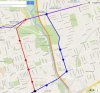
You've missed the most important factor. Your line does nothing to relieve Bloor-Yonge. It's not going to get get people to change from the Bloor line at Castle Frank. It doesn't improve travel times to downtown. And there's no natural ridership on that corridor (AM peak on the Parliament bus is about 3 buses an hour - less than 200 per hour).Well, I am the author of the website www.briangraff.com and actually posted it on Steve Munro's site as well... and one more thing, I am runing for Council in ward 32
let me explain the genesis and reasoning here... from several viewpoints
Sure it's cheaper than a DRL. However, with no relief provided, it doesn't stop the need for the DRL. And is a waste of money.
Not sure why we need anyone else running in Ward 32. McMahon is popular enough, and has wide support (no I didn't vote for her). There's not reason to think she won't win by a landslide (might vote for this time though - because there's no point going back to the past now).
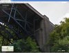
I'm not sure why you think tunnelling a subway in bedrock near the West Donlands would be a problem. The bedrock is shallow - it would be easier to tunnel there, than in the flowing sands on Eglinton. They didn't have any problems with that recent TBM they used to tunnel the new north-south sewer under the same area as far as I know (it was certainly completed on time, without fuss). Why then do you think a subway would be difficult - it's not like your going to put it at ground surface!
Last edited: