Toronto Ontario Line 3 | ?m | ?s

If the western portion is indeed going to be Dundas West (it could also be Keele).

For some reason I can see the TTC cutting corners and using the rail corridor from Dufferin up to Dundas West... Keele would bring out all the Nimby's at Parkside... not to mention tearing up dog walker land... I don't think it would go over well with the general public.

----

as for the Eglinton LRT, if the TTC built the tunnels to subway specs, down the road when the entire line is converted to a subway, they can build a new crosstown tunnel that would go underneath the then already existing LRT (built for subway) tunnel.... meaning four tracks through the centre of the city.... meaning an actual *crosstown* line.
 
Isn't it speed... or in the tunneled section is that not that case? Sorry if I'm dumb!

If nothing else, cost savings.

If Eglinton LRT warrants full separation from traffic (fully underground) then subway cars are significantly cheaper to purchase than LRT vehicles. They don't need to be street safe amongst other things.
 
If nothing else, cost savings.

If Eglinton LRT warrants full separation from traffic (fully underground) then subway cars are significantly cheaper to purchase than LRT vehicles. They don't need to be street safe amongst other things.

Thanks. Are there any numbers out there that say how much a km of underground LRT costs as opposed to underground subway?
 
If the western portion is indeed going to be Dundas West (it could also be Keele). The line could continue to follow Dundas West to an eventual connection with the St Clair and Jane LRT lines in the St Clair, Jane, Dundas West triangle. Creating a significant multi modal transit node, including the possibility of a crosstown GO station. From there it would be a short jaunt under Jane/Scarlet to get to the Eglinton line if need be.
I don't think the DRL going past Dundas West is necessary. It's not important for Yonge relief in that area because the Spadina line does that job already. The demand could be met with the Brampton express rail line planned by Metrolinx, combined with the Eglinton and Jane LRTs. With frequent service and stations at Eglinton, Weston, Jane, and St. Clair, it would have the 2-5 km station spacing that Metrolinx calls for for the most part, and have similar capacity as a subway (according to the draft RTP) because of higher speeds and fewer stations.

I do think that there should be a subway up Don Mills though - that would provide real relief to the Yonge line in the east, which is currently lacking.
 
Last edited:
I think there's some merit to extending the DRL up the Weston Sub in order to serve local stops that a Brampton REX shouldn't.

Stops could serve The Junction neighbourhood, St. Clair West, and Rogers Road, all dense pre-war neighbourhoods. The line could terminate at an intermodal station at Eglinton with REX and the Eglinton Crosstown line. Eglinton, located at the end of Black Creek Drive would be a great location for a park-and-ride and includes a massive site, larger than City Place, that could be redeveloped. Since it could be on the surface, building such an extension could be incredibly cheap. An LRT is another option, and could include even more stops

The nice thing about the Weston sub is that it's on a diagonal to the grid. A subway or LRT line could simply turn off the corridor and head north or west down a number of streets. Keele, Eglinton, Jane, Lawrence/Dixon, Weston Rd, Albion Rd, Islington, Kipling, Martin Grove...
 
The DRL can definitely be conceived of and built in phases. The stretch south of Bloor/Danforth is clearly the most important stretch. Running up Don Mills is a logical next phase that is a prerequisite to significant relief of the Yonge line. Extending it north of Dundas West is not quite the obvious choice as running up Don Mills is since there's no clear corridor (aside from the Weston sub) to serve, but there's always options like running as far as Weston itself, then running along Dixon...it all depends on what actually ends up happening with the various GO lines and airport links.
 
A northwest extension of the line could make sense down the road. I'm partial to running it under Dufferin until Eglinton, if that were to be the case. If we are going to build a subway, we might as well put it where people are as opposed to the rail corridor.
 
A northwest extension of the line could make sense down the road. I'm partial to running it under Dufferin until Eglinton, if that were to be the case. If we are going to build a subway, we might as well put it where people are as opposed to the rail corridor.

This is a good idea as the Dufferin bus is the busiest in the City, as well as a waste of TTC resources. At that point, you could extend it to Wilson Yard and if that was ever done, you could then create a square line by extending the Sheppard line west to Downsview and Wilson Yard... the Toronto LOOP!
 
All this talk of the DRL recently inspired me today to create a "mini DRL" fantasy map. Please excuse the embarrassingly crude nature of my drawing. If someone could make a much nicer, professional looking version of it I would greatly appreciate it! I believe such a route, or a similar one, would have merit in the future. I chose Ossington in the west end since Dufferin would be too close to the main DRL, though a Bathurst alignment could work as well. For east-west, Dundas seems to be a logical route that bissects the core nicely and has a number of important nodes.
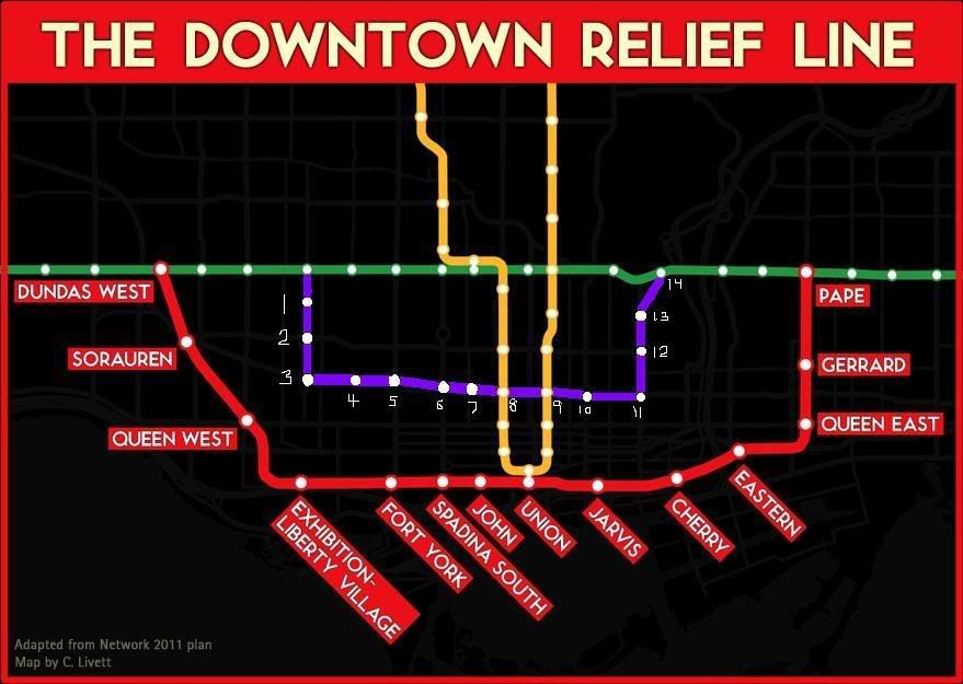
minidrla.jpg


The stations:

1) HARBORD - Probably excessive. I just thought it would be nice to revive the Harbord streetcar route all the way into U of T from this western terminus station.

2) COLLEGE WEST - Gateway to to bustling Little Italy.

3) BROCKTON - Dense older neighbourhood, Ossington retail strip, CAMH down at Queen. Perhaps future access to Liberty Village in the south?

4) BELLWOODS - A small mid-block station between Ossington and Bathurst. Perhaps redundant.

5) KENSINGTON - Western entry point to Kensington Market, as well as the hospital.

6) CHINATOWN - The epicentre of Chinatown and eastern entry to Kensington Market.

7) BEVERLY - The AGO and Grange park. Perhaps excessive.

8) ST. PATRICK - Transfer to University line. Hospital district.

9) DUNDAS - Transfer to Yonge line. Yonge-Dundas Square. TLS. Eaton Centre. Western access to Ryerson U.

10) JARVIS - Major arterial road undergoing intensification and revitalization. Eastern access to Ryerson.

11) REGENT PARK - Massive residential and commercial redevelopment project. Corktown to the south.

12) CABBAGETOWN - Carlton and Parliament, an established, dense older area.

13) ST. JAMESTOWN - Most densely populated block in Canada.

14) CASTLE FRANK - An underused station that would become a vital link in the network.
 
Nice plan. I would alter the alignment to go just south of Queen. A subway south of Front street can be prone to flooding as it would be built on landfill.

Lets hope Metrolinx smartens up and provides funding to the DRL BEFORE it agrees to fund the Yonge extension. Even in phases, the DRL is needed to avoid a massive expansion of Bloor-Yonge that would serve no purpose. As everyone but the politicians already know that the DRL should built at least from Danforth line south and west to at least the CNE grounds to connect with the Waterfront West LRT line.

I'm hoping the feds kick in some major $B's in this January's budget for infrastructure. We all know that it is the best way to come out of a recession, spur development and new jobs.
 
If Eglinton LRT warrants full separation from traffic (fully underground) then subway cars are significantly cheaper to purchase than LRT vehicles. They don't need to be street safe amongst other things.

This is certainly an important part of the equation.

But in the shorter term, the strategy of retaining LRT vehicles on the Eglinton line (even when all of it becomes grade-separate) will be cheaper, as it spares the cost of upgrading the central section, and the inconvenience of closing it for upgrade. Over time, the HRT conversion strategy will be catching up, as each vehicle replacement cycle will be cheaper for subway cars.

Then, how long will it take for the second strategy to outperform the first one? If it takes 30 or 40 years, then conceivably the second strategy is better. But if it is 200 years, then who cares? Teleportation might become the dominant mode of transit by then :).
 
Then why not have Eglington separated into 3 sub lines?

1-Pearson Airport to Keele North Subway Station (LRT 532 Eglington West)

2-Keele North Subway station to Laird (Eglington Subway Line)

3-Laird to Kennedy (LRT 534 Eglington East)

When they get more funds and more ridership to justify a subway(even if I think it should already be a subway); They dismantle a LRT section gradually to add 1 or 2 subway station a year or so.

Bad Idea?


I actually think this is a fairly sensible idea. I hadn't thought of it before, but if we aren't going to use Eglinton as a cross-town corridor, this makes sense to me. The only things I would change would be to move the eastern subway terminus to don mills so that the eglinton east LRT, don mills lrt, and eglinton subway terminate meet in one place. Perhaps the same idea could also be applied in the west by moving the western terminus of the subway portion to Jane so that the Jane LRT, the eglinton subway and the eglinton west LRT all meet.
 
Last edited:
Then why not have Eglington separated into 3 sub lines?

1-Pearson Airport to Keele North Subway Station (LRT 532 Eglington West)

2-Keele North Subway station to Laird (Eglington Subway Line)

3-Laird to Kennedy (LRT 534 Eglington East)

When they get more funds and more ridership to justify a subway(even if I think it should already be a subway); They dismantle a LRT section gradually to add 1 or 2 subway station a year or so.

Bad Idea?

Transfers, transfers ... Transfer City! Say, if I want to get from Dixon & Kipling to Ellesmere & Victoria Park, that scheme will cause me 4 transfers: Kipling bus to LRT, LRT to subway, subway to LRT, LRT to Vic Park bus. (Or, I can forget about the Eglinton corridor, and take two long rides on E-W buses and a short section of Yonge subway.)

In contrast, if a continuous LRT runs along Eglinton, the aforementioned trip will take just 2 transfers.
 

Back
Top