AlvinofDiaspar
Moderator
News release from WT:
Waterfront Toronto to receive $65 million in tri-government funding through the Clean Water and Wastewater Fund
September 14 2016 | Area: Port Lands, Lower Don Lands Topic: sustainable development,

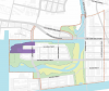
Essroc Quay Lakefilling shown above in green; future re-aligned Cherry St. in grey
Today, the governments of Canada and Ontario announced a bilateral agreement that will make more than $1.1 billion in combined infrastructure funding available under the Clean Water and Wastewater Fund. The federal government is providing up to 50% of this funding for projects while the provincial government and municipalities will cover the remaining costs.
The initial list of projects to receive funding under this program includes Essroc Quay Lakefilling, a project to be completed by Waterfront Toronto. The Essroc Quay Lakefilling project, while part of the proposed scope of work for the larger Port Lands Flood Protection and Enabling Infrastructure project is a self-contained and stand-alone project that can be advanced independently of the lager scope of work.
Essroc Quay is located on the south side of the Keating Channel, where it meets Toronto’s Inner Harbour. The project will create new landmass around the current Essroc Quay through lakefilling. This will stabilize the area shoreline under flood conditions, as the current dockwall on Essroc Quay is old and is at risk of collapsing under flooding conditions. This provides a direct benefit for storm water conveyance.
This project is a prerequisite for significant work required to address a related major storm water conveyance issue: currently, the existing Cherry Street Bridge over the Keating Channel causes a significant hydraulic restriction during flood events. In order to remove this restriction, lakefilling around Essroc Quay is necessary to facilitate the future re-alignment of Cherry Street and the construction of a new bridge that will have a higher span over the Keating Channel to accommodate anticipated flood levels.
An additional part of the project is to divert an existing storm sewer that currently discharges storm water into the Essroc Quay.
The project also includes two pilot studies that will be conducted:
The project will also enhance aquatic habitat and ultimately form part of the proposed Promontory Park, which is a component of the larger Port Lands Flood Protection project.
Subject to Toronto City Council approval, the project will start construction in mid-2017 and will be completed within 18 months. Funding is provided as follows:
The joint press release and backgrounder issued by the federal and provincial governments can be found here and here.
A full description of the Essroc Quay Lakefilling project can be found in Waterfront Toronto’s backgrounder here.
http://www.waterfrontoronto.ca/1999...g_through_the_clean_water_and_wastewater_fund
AoD
Waterfront Toronto to receive $65 million in tri-government funding through the Clean Water and Wastewater Fund
September 14 2016 | Area: Port Lands, Lower Don Lands Topic: sustainable development,
Essroc Quay Lakefilling shown above in green; future re-aligned Cherry St. in grey
Today, the governments of Canada and Ontario announced a bilateral agreement that will make more than $1.1 billion in combined infrastructure funding available under the Clean Water and Wastewater Fund. The federal government is providing up to 50% of this funding for projects while the provincial government and municipalities will cover the remaining costs.
The initial list of projects to receive funding under this program includes Essroc Quay Lakefilling, a project to be completed by Waterfront Toronto. The Essroc Quay Lakefilling project, while part of the proposed scope of work for the larger Port Lands Flood Protection and Enabling Infrastructure project is a self-contained and stand-alone project that can be advanced independently of the lager scope of work.
Essroc Quay is located on the south side of the Keating Channel, where it meets Toronto’s Inner Harbour. The project will create new landmass around the current Essroc Quay through lakefilling. This will stabilize the area shoreline under flood conditions, as the current dockwall on Essroc Quay is old and is at risk of collapsing under flooding conditions. This provides a direct benefit for storm water conveyance.
This project is a prerequisite for significant work required to address a related major storm water conveyance issue: currently, the existing Cherry Street Bridge over the Keating Channel causes a significant hydraulic restriction during flood events. In order to remove this restriction, lakefilling around Essroc Quay is necessary to facilitate the future re-alignment of Cherry Street and the construction of a new bridge that will have a higher span over the Keating Channel to accommodate anticipated flood levels.
An additional part of the project is to divert an existing storm sewer that currently discharges storm water into the Essroc Quay.
The project also includes two pilot studies that will be conducted:
- To assess alternative technologies for dredging and managing sediment in the Channel
- To determine how excavated and dredged materials from the Port Lands and other brownfield sites may be treated through innovative technologies to allow for their potential reuse for purposes such as lakefill – resulting in sediment being treated as an asset, as opposed to a liability.
The project will also enhance aquatic habitat and ultimately form part of the proposed Promontory Park, which is a component of the larger Port Lands Flood Protection project.
Subject to Toronto City Council approval, the project will start construction in mid-2017 and will be completed within 18 months. Funding is provided as follows:
- Government of Canada: $32.5 million
- Province of Ontario: $16.25 million
- City of Toronto: $16.25 million
The joint press release and backgrounder issued by the federal and provincial governments can be found here and here.
A full description of the Essroc Quay Lakefilling project can be found in Waterfront Toronto’s backgrounder here.
http://www.waterfrontoronto.ca/1999...g_through_the_clean_water_and_wastewater_fund
AoD
")