Northern Light
Superstar
The City of Toronto recently finalized a Management Plan for Taylor Creek Park, which is one of the large ravine/valley parks in the City that runs through East York.
The plan may be of interest to some as an illustration of some of the restoration ideas that may be undertaken in the years to come as well as some of the other infrastructure needs and priorities.
As with most Masterplans, a lot of this is high concept, not detailed design. It's not binding on the City but does inform decisions on Ravine Strategy and related investments.
First the link to the plan:
The entire thing from fluffy intros and background to references is 119 pages, so needless to say I will only post a very few select highlights and you should go to the source document for greater detail if interested.
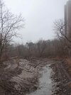
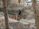
First an image of the park in question:

The Park is full of CSOs or Combine Sewer overflows that currently dump untreated sewage in the creek during intense rain/snowmelt events. This is unfortunately the norm for most watercourses in Toronto with the exception of the Rouge.
As part of addressing this problem and the attendant pollution, the pipe now being built along the Lower Don and Waterfront areas will be extended along Taylor Creek to the Warden Avenue trunk sewer. The map below reflects that, which is important to note as many of the restoration projects will be tied to this work. The straight green line at the eastern extent of the work is parallel to the Warden Trunk Sewer.

***
The trail map shown below features 2 new trail segments, one in the hydro corridor on the south side of the valley that is roughly 1/2 way up the slope, which would run between the existing access at Lumsden/Barrington and Stan Wadlow Park. Note that this is the historic ROW of the Canadian Northern Railway, which is occupied by Line 2 (Bloor Subway) between roughly Victoria Park Station and Kennedy Station (underground from just east of Warden)

The one additional dot reflects a new N-S connection into the valley from an old, poorly maintained staircase at the foot of Chisholm Ave.
***
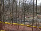
Unfortunately, due to the way we used to treat ravines, most of the ravines in Toronto have one or more significant landfills in them, this park is no exception:

***
A High level look at the types of restoration and their locations, that are being contemplated:

The restoration projects are mostly grouped into areas of geographic proximity with the idea that those that require professional crews/construction can be undertaken in one mobilized effort where practical.
Below is the concept for the west end of the park near the DVP. This is again very high level, lots of design work still required and further changes are likely:

There are six of these clusters, it would take to many posts to show all the images, but I will share a couple more. Additional details are in the linked Plan, but I'm also happy to answer any questions I can.
In respect of the one above, key projects include a new wetland, and consolidation of the paved trail to one side of the creek from two, to create a restoration opportunity with limit people access.
****
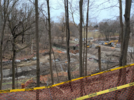
The area below is immediately to the east of the one above.

One key idea noted above is the removal of the existing weirs or in-creek vehicle crossings (which currently have parallel wooden pedestrian bridges.)
The notion here is to consolidate all crossing on new vehicle-grade metal bridges, then remove the superfluous bridge and restore the surplus lands that are now largely mowed, typically about 1 acre at most sites (there are 3 such crossings of Taylor Creek.
Additional work includes removing some informal trails that create erosion, and looking at removing invasive species from natural seep area to create a proper wetland.
****
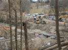
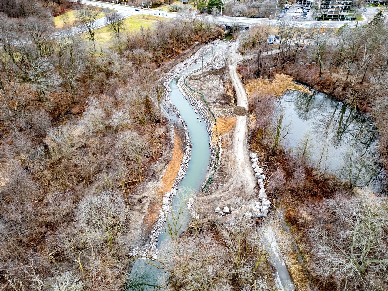
The image below covers the area below Stan Wadlow Park. This area will be the most disrupted by the Toronto Water Project as one of those giant tanks you can see looking down from the Bloor Viaduct will be going in here. There will be a very large excavation area and a great deal of vegetation will be removed.
However, outside of some small restoration sites, much of what's here is lawn, invasive species and an abandoned washroom.

The final site I'll post is the Goulding Estate area, east of Dawes Road:
The signature project here is to replace perpetually flooding bike path with an elevated boardwalk (that you can cycle on, it will likely be vehicle grade as well, but that is TBD). This will allow an existing wetland to connect to the creek:

The plan may be of interest to some as an illustration of some of the restoration ideas that may be undertaken in the years to come as well as some of the other infrastructure needs and priorities.
As with most Masterplans, a lot of this is high concept, not detailed design. It's not binding on the City but does inform decisions on Ravine Strategy and related investments.
First the link to the plan:
The entire thing from fluffy intros and background to references is 119 pages, so needless to say I will only post a very few select highlights and you should go to the source document for greater detail if interested.
First an image of the park in question:
The Park is full of CSOs or Combine Sewer overflows that currently dump untreated sewage in the creek during intense rain/snowmelt events. This is unfortunately the norm for most watercourses in Toronto with the exception of the Rouge.
As part of addressing this problem and the attendant pollution, the pipe now being built along the Lower Don and Waterfront areas will be extended along Taylor Creek to the Warden Avenue trunk sewer. The map below reflects that, which is important to note as many of the restoration projects will be tied to this work. The straight green line at the eastern extent of the work is parallel to the Warden Trunk Sewer.
***
The trail map shown below features 2 new trail segments, one in the hydro corridor on the south side of the valley that is roughly 1/2 way up the slope, which would run between the existing access at Lumsden/Barrington and Stan Wadlow Park. Note that this is the historic ROW of the Canadian Northern Railway, which is occupied by Line 2 (Bloor Subway) between roughly Victoria Park Station and Kennedy Station (underground from just east of Warden)
The one additional dot reflects a new N-S connection into the valley from an old, poorly maintained staircase at the foot of Chisholm Ave.
***
Unfortunately, due to the way we used to treat ravines, most of the ravines in Toronto have one or more significant landfills in them, this park is no exception:
***
A High level look at the types of restoration and their locations, that are being contemplated:
The restoration projects are mostly grouped into areas of geographic proximity with the idea that those that require professional crews/construction can be undertaken in one mobilized effort where practical.
Below is the concept for the west end of the park near the DVP. This is again very high level, lots of design work still required and further changes are likely:
There are six of these clusters, it would take to many posts to show all the images, but I will share a couple more. Additional details are in the linked Plan, but I'm also happy to answer any questions I can.
In respect of the one above, key projects include a new wetland, and consolidation of the paved trail to one side of the creek from two, to create a restoration opportunity with limit people access.
****
The area below is immediately to the east of the one above.
One key idea noted above is the removal of the existing weirs or in-creek vehicle crossings (which currently have parallel wooden pedestrian bridges.)
The notion here is to consolidate all crossing on new vehicle-grade metal bridges, then remove the superfluous bridge and restore the surplus lands that are now largely mowed, typically about 1 acre at most sites (there are 3 such crossings of Taylor Creek.
Additional work includes removing some informal trails that create erosion, and looking at removing invasive species from natural seep area to create a proper wetland.
****
The image below covers the area below Stan Wadlow Park. This area will be the most disrupted by the Toronto Water Project as one of those giant tanks you can see looking down from the Bloor Viaduct will be going in here. There will be a very large excavation area and a great deal of vegetation will be removed.
However, outside of some small restoration sites, much of what's here is lawn, invasive species and an abandoned washroom.
The final site I'll post is the Goulding Estate area, east of Dawes Road:
The signature project here is to replace perpetually flooding bike path with an elevated boardwalk (that you can cycle on, it will likely be vehicle grade as well, but that is TBD). This will allow an existing wetland to connect to the creek:
Last edited: