Toronto Queens Quay & Water's Edge Revitalization | ?m | ?s | Waterfront Toronto

Anyone else getting the feeling that the term "shared space" is becoming an easy excuse for bad urban design?

"This street design has created a conflict zone!"
"Uhhh... it's shared space! I totally intended for that to happen!"

Except "Shared space" doesn't mean cyclists can run red lights, or that pedestrians can cross a bike lane during a red pedestrian crossing light.

Eliminating the concept of shared space here would make absolutely no difference, since the shared space concept isn't the problem. People not following basic rules is the problem. (And the configuration of the crosswalk buttons, which is an easy fix)
 
There's a bit of a bruhaha brewing in Ward 6. The Humber Bay Park trails are too narrow and there have been a few dog-cyclist collisions resulting in the poor pooch's death, and a few pedestrian-cyclist collisions as well.

I know I'm always in danger of making people roll their eyes when comparing things to The Netherlands, but when it comes to bike infrastructure they're really got things so much more figured out than we do.

The lesson in this case is, serious bike paths need sidewalks too. Cyclists getting where they need to go and pedestrians don't mix like cars and pedestrians don't mix (unless everyone is moving at the same speed - 5 km/h).

Here's one pic I have. This design is typical.
CFJDWfYWYAAEAj8.jpg
 

Attachments

  • CFJDWfYWYAAEAj8.jpg
    CFJDWfYWYAAEAj8.jpg
    162.5 KB · Views: 270
Last edited:
Except "Shared space" doesn't mean cyclists can run red lights, or that pedestrians can cross a bike lane during a red pedestrian crossing light.

Well, I was meaning this more in reference to the location of the pedestrian crosswalk button. But the thing is, that since this is a "mixed use trail" (shared space), pedestrians CAN cross this bike lane during a red pedestrian crossing light. There isn't a clear division of space for different uses and it seems to be that it's creating issues.

We keep saying that people need to slow down and "share", but we keep having conflicts anyway. It isn't working! As nice as it seems and as good as the intentions are, I think the idea of "shared space" in anything but extreme low-traffic situations is flawed to begin with.

(And of course cyclists shouldn't be running red lights. That's a whole other issue, IMO.)
 
I haven't been to the Netherlands for years, but I remember the very separated spaces for all modes of transportation -- although crossing at an intersection could be an adventure!
 
I cycle down there often. There are absolutely some cyclists who ride too fast, but there are also people with those stupid extenda-leashes (which are great in the park, not so great on a multi-use path) and off leash dogs.

On that note, owners of these small dogs really need to keep their dogs close to them. I'm not going to notice their four inch tall dog crossing my path. I've already kicked one of those dogs by accident because the owner had it on one of those stupid long leashes in a busy park.
 
I overlook the controlled chaos that is the Bay Street intersection, and I'm actually impressed how well it seems to work. Yes there have been a few near-misses, but overall people seem to be getting the hang of it.
Unfortunately along other stretches I've already witnessed numerous "militant" cyclists yelling at people to "get out of the bike lane" and giving people the finger, even in the mixing zones, where they do not have any priority.
 
Unfortunately along other stretches I've already witnessed numerous "militant" cyclists yelling at people to "get out of the bike lane" and giving people the finger, even in the mixing zones, where they do not have any priority.

The space is 99% fine - it only takes one or two of these types to ruin it.

AoD
 
The Humber Bay section of the Waterfront Trail usually sees me ride on Marine Parade Drive instead these days. You're right, it's narrow, and those signs put up by the local resident association telling cyclists to slow down aren't helping much.

Really, I think part of the answer is wider trails - like in the Lower Don, and better segregation on the MGT. There are plenty of places where bikes are not permitted (the boardwalks in the Eastern and Western Beaches) and the wide sidewalk on Queen's Quay; where this happens, signs and other devices should be used to say that this path is intended for higher-speed users like joggers, rollerbladers and cyclists - not for meandering families. It's about courtesy on the pedestrians' side too.
 
Really, I think part of the answer is wider trails - like in the Lower Don, and better segregation on the MGT. There are plenty of places where bikes are not permitted (the boardwalks in the Eastern and Western Beaches) and the wide sidewalk on Queen's Quay; where this happens, signs and other devices should be used to say that this path is intended for higher-speed users like joggers, rollerbladers and cyclists - not for meandering families. It's about courtesy on the pedestrians' side too.

Unfortunately QQ has limited real estate - you don't have a huge option of having significantly wider trails without cutting into the amount of pedestrian space. The issue I've observed in the central section is mainly excessive speed.

AoD
 
^^ I couldn't agree more. We have shared space everywhere -- intersections anyone?
Yes, but as intersections are one of, if not the top, locations for accidents to occur, engineers attempt to design the 'shared space' to minimize the conflict.

Just because it is shared space does not eliminate the obligation of the designers to minimize conflict that could lead to serious bodily harm.
 
I just saw this, and it relates to discussion of shared space, other bicycle-related discussions, and an earlier post about the Dutch. There's some photos in here that look no different in terms of pedestrian/cycling shared space. In some of them, there aren't even the barriers of trees that QQ has, and the colour of the brick/path are very similar whereas QQ's bike path stands out colour-wise from the pedestrian sections. It doesn't show us how the intersections work, however :)

Perhaps the Dutch have just learned how to use their shared spaces, and we've just started
http://spacing.ca/vancouver/2015/03/30/cycling-lessons-learned-amsterdam-no-one-talks/
 
Anyone else getting the feeling that the term "shared space" is becoming an easy excuse for bad urban design?

"This street design has created a conflict zone!"
"Uhhh... it's shared space! I totally intended for that to happen!"

Exactly!

What these designers call "shared space" is simply poor design: providing an unclear situation that does not provide the information people need for safely and comfortably navigating the space.

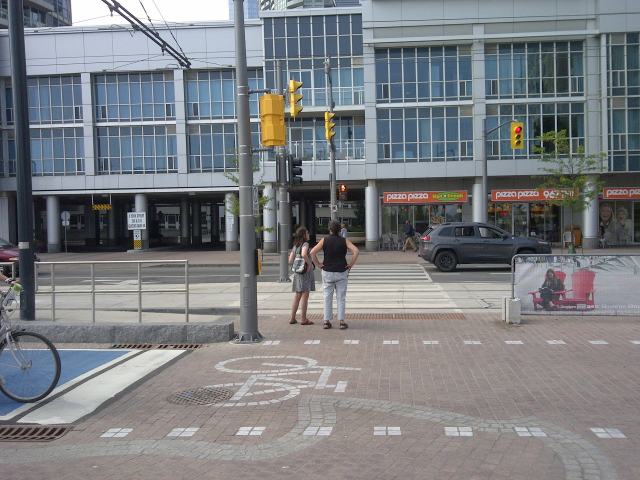
If you look at the conflict point from the pedestrian's perspective, the continuous paving undermines the efforts to subconsciously alert you of a conflict, and many people don't even notice the bicycle path at all. Shared space depends on human interaction, but there can't be a negotiation right-of-way when one party is not even aware of the other.
img-20150706-00272.jpg


When you look at the conflict point from the perspective of a cyclist your eyes see the markings clearly delineating the bike path (from that angle) and assume that pedestrians should keep out of your way.
roberstonwb.jpg


The differing expectations that different road users are given is a recipe for people to get annoyed and upset with each other.

We need to update the design so that it is intuitive to all road users how they should act.
qqspadina_crossing.jpg


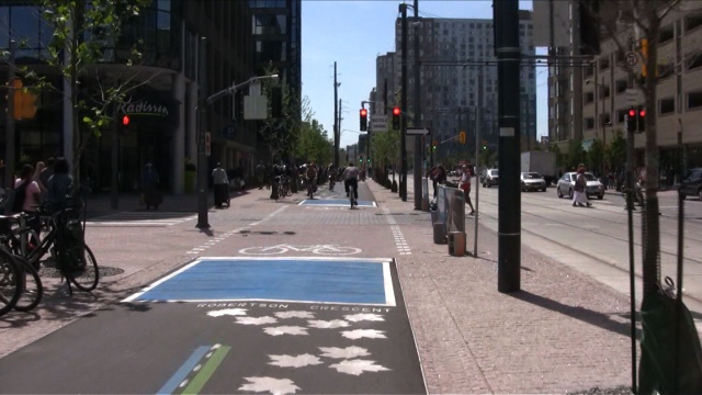
Shared space works well where everyone is traveling slowly and the number of vehicles are low (i.e. dead-end streets). It is not appropriate on a street such as Queens Quay which is one of the major east-west bicycle routes through the city. People's issue of "excessive speed" is equally a symptom of "insufficient design". Keep in mind that no one is complaining about the speed of streetcars and automobiles, which are actually travelling much faster than the bicycles.

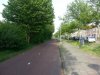
A successful nearby example of shared space is Dockside Drive along the waterfront, just next to Sugar Beach. It's only used for local access, so the few people who are driving or cycling are travelling very slowly as there is no clearly delineated space for vehicles - it is visually a pedestrian zone.

All images are from ontariotrafficman.wordpress.com/2015/07/28/queens-quay-boulevard-cycle-track-reconciling-cyclists-and-pedestrians


^^ I couldn't agree more. We have shared space everywhere -- intersections anyone?

I think there is some confusion about what "Shared Space" is. It refers to the designs and theories popularized by Hans Monderman where all delineation and segregation is removed from roadways, and instead road users must negotiate priority with each other.

Intersections are not Shared Space since they have legally-defined rules and expectations. For example a pedestrian crossover is a place where the space is "shared" by pedestrians and vehicle traffic, but it is not "shared space" in the Monderman-ian sense since pedestrians officially have priority over vehicle traffic.

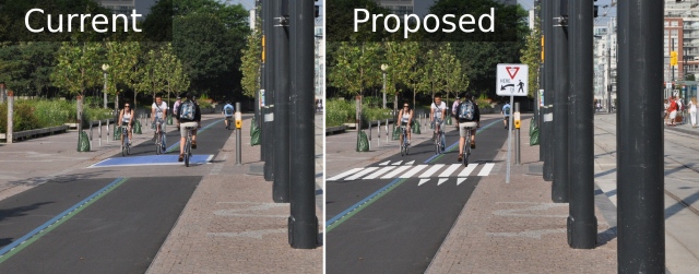
Suggesting that Shared Space can work successfully in a 4m x 4m square within an otherwise highly delineated streetscape is nothing short of absurd. People are all passing straight through the zone, some with considerable momentum.

The most familiar example of Shared Space to us is parking lots: there is no clear right of way in most situations and there usually isn't any separate space for pedestrians or cyclists.
 
Last edited:
Waterfront Toronto is planning to fix the confusion by adding more signs. They're going to make it worse.

This is a serious problem with the Ontario Highway Traffic Act. Unlimited custom signs are permitted to add conditions to existing signs. Drivers should not be expected to read large blocks of text while driving. Iconic signs work much better.

It's turning out that the removal of the grass ROW has had a significant impact on the intuitive nature of the new Queens Quay. Look at this image:

queensquay2.jpg.size.xxlarge.letterbox.jpg


Drivers see this entire set of lanes on the left. Intuitively, it feels like Westbound drivers should be in these 2 lanes while Eastbound drivers should use the 2 on the right. A grass ROW would have created a visual delineation that is unmistakably not for cars. In that context, it becomes clear that there's one lane in each direction on the remaining paved road.

The grass ROW also created a visual reference where cyclists should stop:

urbantoronto-6731-29317.jpg


Further, a concrete streetcar ROW creates an intimidating crossing for pedestrians. This large expanse of paving with very short green light/very long red light cycles is not at all pedestrian friendly.

Waterfront Toronto underestimated the effect that removing the grass ROW would have on the overall design. They should build it.
 

Back
Top