


ponyboy
Active Member
Sorry I couldn't find any discussion about this. I am not a rail expert, but know there are many on this forum.
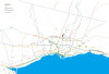
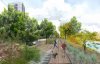
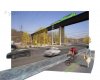
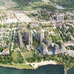
I just learned about an interesting and bold scheme to transform the entire Don Valley into a contiguous park, requiring consolidating two rail lines into one, opening the Don river by turning the rail line between Bayview and the river into a bike path. I'm not certain, but I believe that the rail line along the river from Brickworks north to Lawrence will be moved to the rail corridor that goes through Thorncliffe park. Is there capacity on those tracks? South of Brickworks, the rail line would be shoehorned in on the east side of the river, opening up the banks on the west side of the river. Can this be done? Looking on google earth, it looks quite tight. It will be a tight squeeze south of Gerrard, and a couple of lanes of the DVP will have to be shifted east to accommodate the expanded rail line, and overpasses extended, but I guess it can be done apparently.
The plan would also simplify the Bloor exits from the DVP and remove a city depot to open up the space. Bike lanes on Bayview and Rosedale valley road will be installed. It is a pretty amazing scheme, and it would be great to see such a bold plan put into action, assuming that issues of congestion and access are addressed with the plan.
The proposal is being discussed on Thursday night at the Brickworks.
http://www.theglobeandmail.com/news...ley-waiting-to-be-discovered/article29648565/