News   Apr 26, 2024
 2.4K     4 
News   Apr 26, 2024
 616     0 
News   Apr 26, 2024
 1.2K     1 

Miscellany Toronto Photographs: Then and Now

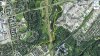
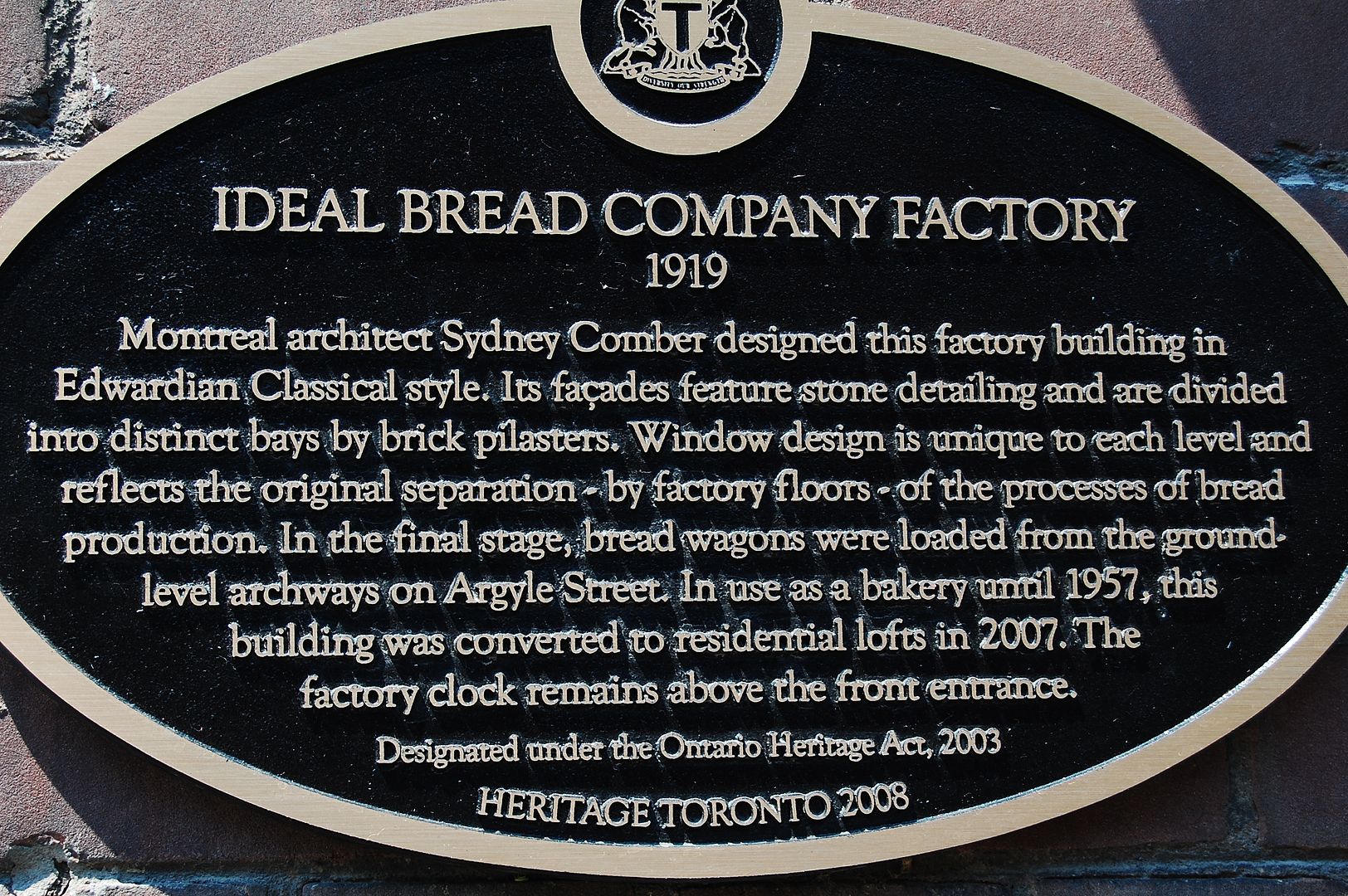
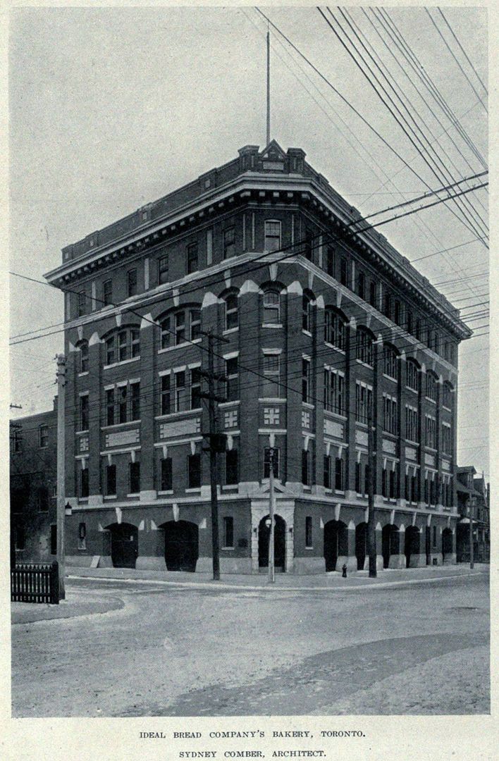
Some shots of all those changes being made

s0065_fl0066_id0004.jpg


s0065_fl0066_id0019.jpg

These shots were taken from the "lookout" at the end of Chester Hill & Thorncliffe. It's my childhood view. Just looked, nothing in my library representing this picture. I gotta fix that. Actually, this might be out along the footpath. Seems a bit close to the onramp road to DVP North.

First Picture: You can see the very last remnants of the road between the Brickworks and Todmorden. Second picture, it's gone.

Second Picture: What a gem. Everything is so clean...which probably aided in many accidents. The separate feed coming North on Bayview onto Pottery Road is now gone, with the recent improvements. As is the separate branch leading to Bayview North from Pottery Road. It's just a simple T-intersection now with a light. I've almost taken out drivers who didn't see the yield sign going North, while I was joining Pottery coming from the North. It's a bit of a raceway. The median in the foreground there is still being used though, but the stripeys are now gone.

Am I right to remember this intersection being like this in the past 40 years? I mean, no lights?
 
"Interesting they would ship POWs this far inland. Very interesting."
QUOTE Mustapha.

My grade 10 home room teacher was a German POW in Northern Ontario.


Regards,
J T
 
"No no, thank YOU! And sorry for my mistake. D'oh!"
QUOTE wwwebster.


I cannot offer any reference, but I am inclined to believe that Queen Street numbering has changed

at the least once due to "infilling". This is not to be confused with changes in actual street renaming

changes such as the renaming of Don Mills Road above Queen to Broadview Avenue, the "removal"

of Scadding Street below Queen to Eastern and laterly added to the latter, nor does it apply to the

renaming and renumbering of Lakeshore Road to Lakeshore Boulevard West.

(After reading my above post, you thought you were confused!)

(LOL)


Kind regards,
J T
 
Another old road - to be explored?

Speaking of old streets (Pottery Road in particular), I noted in this Google aerial (attached) that there is a faint line describing an old road that may have been the route for Lawrence Ave. across the Don Valley (before the bridge & the Parkway).
At Lawrence the road is named 'Old Lawrence Ave.' and it seems to go through the valley as far as the present 'Green Belt Dr.' which, in turn, would lead to Don Mills Rd.

Does anyone have an older aerial which would clearly show this route through the valley?

I'd love to explore that old trail.
 

Attachments

  • Old Lawrence Ave. route to Green belt Dr?.jpg
    Old Lawrence Ave. route to Green belt Dr?.jpg
    109.8 KB · Views: 287
These shots were taken from the "lookout" at the end of Chester Hill & Thorncliffe. It's my childhood view...
Second Picture: What a gem. Everything is so clean...

I didn't recognize that intersection at first. As you said, everything looks so clean & new. Here's some more

the new course of the Don
s0065_fl0091_id0012.jpg


this has to be a temporary bridge over the 'new' river, right?
s0065_fl0091_id0013.jpg

s0065_fl0091_id0015.jpg


And here's one especially for you, BeeRich
s0065_fl0091_id0009.jpg
 
I didn't recognize that intersection at first. As you said, everything looks so clean & new. Here's some more

the new course of the Don
<snip>

this has to be a temporary bridge over the 'new' river, right?
<snip>

here's one especially for you, BeeRich

You know, I'm in no way a fan of history. Never have been. These pictures blow me away. These are just so fantastic, yet they are pictures of an old neighbourhood. Very strange indeed.

Picture 1: I couldn't tell you if the bank on the south side there is still as high. It looks too manufactured, indeed.

Picture 2: It does look temporary. Those trees on the bank are now gone, as the trail runs up right beside the river.

Picture 3: Look, everybody working, and only one supervisor/fan. Quite the reverse these days.

Picture 4: Jaw dropping. They moved the rail over towards the camera in order to accommodate the DVP. This must be the new position. The dirt just above the tracks is where the "supercalifragalisticexpyalidocious" is spray painted. I knew the people who lived in those houses. One of them has been homeless for 25 years apparently.

http://torontoist.com/2007/05/something_quite/

Thanks for the post.
 
Goldie, I couldn't spot "Old Lawrence Ave" on Google Maps, but Lawrence East stops at Bayview and to continue east you have to go up to the Post Road and south again to get back to it. But if you continue directly across Bayview from the west, you are in the grounds of Grendon Hall of York University. There is a path that one can see between the trees on the map manoeuvering southeast, but it seems to come out into the open at Glenorchy Ave--not all that far away.
There were some photos from this area on the forum a year or two ago. There was a bridge and discussion as to how to get up to it and how long it had been there.
 
Speaking of old streets (Pottery Road in particular), I noted in this Google aerial (attached) that there is a faint line describing an old road that may have been the route for Lawrence Ave. across the Don Valley (before the bridge & the Parkway).
At Lawrence the road is named 'Old Lawrence Ave.' and it seems to go through the valley as far as the present 'Green Belt Dr.' which, in turn, would lead to Don Mills Rd.

Does anyone have an older aerial which would clearly show this route through the valley?

I'd love to explore that old trail.

Goldie, look at these photos from Lone Primate.
http://cityinthetrees.blogspot.com/2011/04/lawrence-avenue-pony-truss-bridge.html
 
Man, I have to meet some of YOU!
I THINK some of us have much in common. Rich, and many others. The Pottery rd and its recent publicly has been enlightening.
 
Re: POW camp in Todmorden during WWII

"Interesting they would ship POWs this far inland. Very interesting."
QUOTE Mustapha.

I suppose POW camps were kept away from coastlines.
The dangers of POWs stealing a boat and rowing back home were obviously worrisome!

There was a large POW camp at Bowmanville, Ont.
I wonder if any took the St. Lawrence route to the sea.
 
"Man, I have to meet some of YOU!
I THINK some of us have much in common. Rich, and many others. The Pottery rd and its recent publicly has been enlightening."
QUOTE mattelderca


THIS SUNDAY?

Same place as "before"?

Time 11:00 AM

If interested, inbox/email me.


Regards,
J T
 
"Man, I have to meet some of YOU!
I THINK some of us have much in common. Rich, and many others. The Pottery rd and its recent publicly has been enlightening."
QUOTE mattelderca


THIS SUNDAY?

Same place as "before"?

Time 11:00 AM

If interested, inbox/email me.


Regards,
J T

Can't make it. Tis the season, etc.
 
Then and Now for Dec 7.


Then. Ideal Bread Company's Bakery. NE corner of Dovercourt and Argyle. c1920. A wwwebster pic.

DSC_0021-2.jpg


DovercourtArgyleNEc1920.jpg


Now. Condominiums. Expanded over the years too, like a loaf.

CSC_0020.jpg
 
Speaking of old streets (Pottery Road in particular), I noted in this Google aerial (attached) that there is a faint line describing an old road that may have been the route for Lawrence Ave. across the Don Valley (before the bridge & the Parkway).
At Lawrence the road is named 'Old Lawrence Ave.' and it seems to go through the valley as far as the present 'Green Belt Dr.' which, in turn, would lead to Don Mills Rd.

Does anyone have an older aerial which would clearly show this route through the valley?

I'd love to explore that old trail.
There is a photo in the Don Mills thread that shows the old route of Lawrence. It did not come down as far as Greenbelt. You can easily walk that trail, either from the east side, down Old Lawrence (which is where Lawrence looped back up toward the present route after crossing the Don in the valley), or from Moccasin trail park. They just put in place a foot bridge last year to cross the river just north of the "rainbow tunnel" and paved the trail the whole way. I have often gone down here with my camer or bike or both (even before the bridge). I live right nearby on the west side of the DVP.

EDIT: I did not see someone had replied before I did. However, the path info can be useful.
 
Last edited:

Back
Top