News   Apr 26, 2024
 1.7K     4 
News   Apr 26, 2024
 369     0 
News   Apr 26, 2024
 943     1 

Lost Neighbourhood: Blondin Avenue

Thanks for posting the plan... fascinating!

I'm not sure what the costs will be or what the cost of accessing 1947 is. For the most part, 1950 is nearly as good. The city really started to change with the construction of the 401 in 1952, 1953, and thereabouts. At least the stuff I'm mainly interested in.

I know you were discussing Flindon... how do you think I found you guys? :) I was there a week earlier, and then went down to the Archives to explore it Friday. I'll post some of that soon. Pretty surprising, some of it.


i only found out about the flindon road bridge a little while ago from a pic i saw on the internet. i just went back and looked at that pic again and realized who took it! LOL!!!!! this is retarded!
 
Very interesting stuff, Lone Primate.

Another road that was likewise transformed was Passmore Avenue. When north Scarborough was subdivided a la Don Mills, Passmore was cut up into a dozen new and discontinuous roads. It's the kind of change that is not noticeable unless you're looking at maps or air photos (or are high up on a roof looking down the corridor). Paths do exist along the old alignment, connecting the courts and crescents together so that you can walk or bike (but not drive) the entire length of what Passmore used to be, all the way from Malvern to the 404.
 
6bc64ja.jpg


1953
 
Excellent post!

My first short article in Spacing (a last minute call-up) was on the weird interesction of Albion, Walsh and Weston. I mentioned the disappeared Blondin Avenue in the article, and still no one knows why all the houses disappeared, while the neighbourhood is intact on the north side.

Blondin was well known as a bus loop until the interchange was built - it was the end of the Weston 89 Trolley Coaches, as well as serving Wilson and Woodbridge buses. I have a postcard somewhere that shows a Marmon-Harrington Trolley Coach pulling out of Blondin Loop (with the post war 1 1/2 floor houses behind) in the early 1970s.

The Westchester sales office has been abandoned for at least a year now. Don't know what Sorbara Group is up to there anymore.

Thank you, SeanTrans! :) Wow, that postcard sounds incredible. I hope you can find it; I'd love to see what the place once looked like.

Do you know when the neighbourhood was pulled down? It's hard for me to judge.

Interesting that the sales office is abandoned. I didn't try going in when I was there. Wonder if that one surviving place, #35, killed the whole deal. :)
 
Wow, Prometheus, what a remarkable shot up there!
 
Very interesting stuff, Lone Primate.

Another road that was likewise transformed was Passmore Avenue. When north Scarborough was subdivided a la Don Mills, Passmore was cut up into a dozen new and discontinuous roads. It's the kind of change that is not noticeable unless you're looking at maps or air photos (or are high up on a roof looking down the corridor). Paths do exist along the old alignment, connecting the courts and crescents together so that you can walk or bike (but not drive) the entire length of what Passmore used to be, all the way from Malvern to the 404.

Ha! Passmore's another one I studied; I took some shots in the vicinity of where it was around Morningside Creek. Passmore's interesting because it's one of the few 'major' streets in what was Metro that I'm aware of that's been largely erased from our consciousness.
 
Well, it still is "Passmore" for two segments. I do agree that it's largely forgotten but that's partially because the two segments still called Passmore are adjacent to some of the last greenfield properties in the city...perhaps the name was never changed in these two spots precisely because they were development zones so late in the game (and maybe we're long past the era where there's *any* impetus to change such names, so I guess they'll stay).

edit - and, really, McNicoll "became" a de facto Passmore; stole its identity, if you will. McNicoll was widened to 4 lanes and has all the charm of a highway now. Steeles was a two lane country road back then and has also been improved...most of it even has curbs now!
 
Yup, up at the top, broken by the Humber. By 1965, the bridge was gone, though I didn't know that till Friday. In 1961, the bridge was still there, sharing duty with Albion Road. In 1962, it's gone... just the abutments. Today only the east abutment still exists; the Etobicoke side is utterly erased.
 
Steeles was a two lane country road back then and has also been improved...most of it even has curbs now!

Somebody I used to work with told me that when she moved to North York in 1968, Steeles was still a dirt road. Hard to imagine, but I suppose it's possible.
 
Passmore is an interesting study. Other disappeared or endangered concession/side roads in the GTA:

Second Line WHS - in Mississauga now relegated to a minor collector road in favour of Mavis, severed at New Derry Road/407, eliminated in a subdivision nort of Britannia, and soon to be severed again at the 401. In Brampton, Mavis merges into Chinguacousy, where Second Line WHS is much more important.

Third Line WHS: Creditivew Road. The opposite - still relatively important in Mississauga, but also severed by New Derry Road and the 407. In Brampton, has disappeared south of Highway 7, in favour of something called James Potter Road.

Related, in Mississauga, I think Purivale/Rathkeale served a more important purpose than it does now - another road that looks really out of place. I wonder if it was an old road to Streetsville or something.
 
Second Line WHS... Creditivew Road.... Purivale/Rathkeale served a more important purpose than it does now - another road that looks really out of place. I wonder if it was an old road to Streetsville or something.

Wow, God, you guys are hitting all my buttons. :)

I used to live in Mississauga for years and years, and I actually got to drive Second Line and Creditview when they were going concerns. They were no hell, but at least they still went through. You could drive all the way from Eglinton well up into Brampton on Second Line with no interruption. I was sad when they started carving it up. There actually used to be traffic lights at Creditview and Derry (or what's now "Old Derry"); they've taken them down and it's just stop signs now. How the mighty have fallen. Ditto Creditview; we used to turn onto it off Derry back in the late 80s and early 90s to go to the various parks along it in Brampton. Now it's barely even worth of the name footpath there.

In the last year and half I've been back to both roads, and I have shots on either my blog or my Flickr account... I'll have to dig them up. 
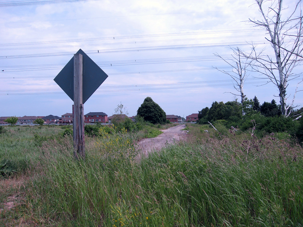
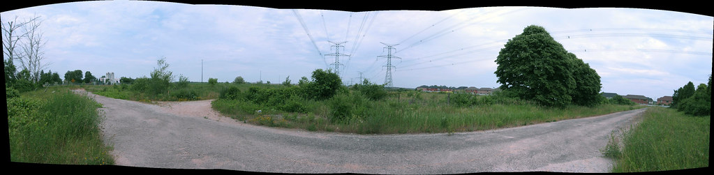
Second Line is still easy to get to; there are some interesting properties along it that I can vaguely remember passing in the years right after I got my license. There's a little chunk of Creditview just south of the 407 that still exists, about 200 feet long, but it's harder to get to, and probably won't be accessible at all that much longer. You have to trek in to it through the fields east of Financial Drive.

170985670_e47e9e387a_b.jpg


170985008_1f7f5b6598_b.jpg


Closed Creditview between the 407 and new subdivision, summer, 2006.


I can remember when Mavis had its northern terminus at Eglinton Avenue. Around the time I started driving, they were just roughing in the new course as far north as Britannia. I had no idea back then it was going to be come the main street it is now, or just how crippled it was going to render Derry Road.

As for Rathkeale and Perivale, they were among the first roads I started studying back in the early 90s. They were, in fact, the original course of Creditview Road to Burnhamthorpe till sometime in the early 70s or so. They're disconnected because the 403 was built and there was utterly no need to bridge it because Creditview had its newer, current course by then. McConnell Road in the same area is the remnant of a more extensive road that was really effectively there to serve the hydro corridor, but I suspect it made life a little easier for the local farming community at one time long ago.

Mississauga is an absolute gold mine of old forgotten roads. In fact, it was the now almost complete obliterated Fifth Line West that got me started on the whole subject back in 1990.
 

Back
Top