r937
Active Member
archaeological dig?
apologies for not posting these sooner
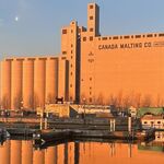
starting at the wicksteed level crossing of the main cp line --

proceed to walk along the east side of the building --

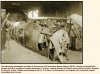
old infrastructure, slowly decaying in situ --

some predator had lunch here, and only feathers remain as evidence --

over the lip of the hillside, some refuse can be see, but nothing metal --

there's a footpath which skirts the top of the hill --

proceed with caution down the hillside --

the footpath leads to the cp trestle --

awesome to think that this was built in 1884 --

anyhow, regarding the archaeological dig, i'd still be up for it, but i'd have to say that finding anything is a long shot
i took the following photos early in the morning on good friday, april 6 2012, to give context to the location for a possible UT meeting with Goldie and others, for the purpose of digging around for evidence of an aircraft graveyardI think I'd like to make a documentary film of this proposed archeological "dig"
apologies for not posting these sooner
starting at the wicksteed level crossing of the main cp line --
proceed to walk along the east side of the building --
old infrastructure, slowly decaying in situ --
some predator had lunch here, and only feathers remain as evidence --
over the lip of the hillside, some refuse can be see, but nothing metal --
there's a footpath which skirts the top of the hill --
proceed with caution down the hillside --
the footpath leads to the cp trestle --
awesome to think that this was built in 1884 --
anyhow, regarding the archaeological dig, i'd still be up for it, but i'd have to say that finding anything is a long shot


")