News   Apr 26, 2024
 1.8K     4 
News   Apr 26, 2024
 407     0 
News   Apr 26, 2024
 1K     1 

Evocative Images of Lost Toronto

Cool maps!

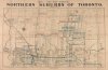
I need to solve that Pottery Road mystery though. Although my guess is that the gentleman's memory is not the best and he mistook it for Royal Drive.

I think you're right. The Oct 11th Star outlines all of the routes around town. No mention of Pottery Rd anywhere.

4.15 pm - Their Royal Highnesses will leave Riverdale Park for Sunnybrook Hospital.
Route: North on Royal drive to Bloor St., west on Bloor St. to cutoff to Mount Pleasant Rd., north on Mount Pleasant Rd to Moore Ave., east on Moore Ave to Bayview Ave, north on Bayview Ave. to Sunnybrook hospital.
 
I think this photo will fit in this thread ...

Photo was taken c. 1931 at Sunnyside. They were were on their way to perform in a choral presentation. My Mother, on the right, was in a number of choirs at that time. The lady on the left became my Godmother 20 yrs later.

1931c-MomandDorisSunnysidecirca_s.jpg
 
Map (attached) of Toronto above Bloor St. - 1890

Intersection of Lawrence E. and Bayview is one of the interesting features.
 

Attachments

  • map Toronto N. of Bloor 1890.jpg
    map Toronto N. of Bloor 1890.jpg
    98.3 KB · Views: 463
I found this old snapshot recently - I must have made it in the early 1950s.

Perhaps someone will recognize the location - I have no idea!

Toronto1950s.jpg
 
Thanks - that's quite a surprise. I thought it would have been Toronto.
I don't recall being in Ottawa at that time.
Of course, that was 60 years ago!
 
Map (attached) of Toronto above Bloor St. - 1890

Intersection of Lawrence E. and Bayview is one of the interesting features.

I've long wished there were some way to put Lawrence through there, but it's probably way more trouble than it's worth. Still, nobody really lives on Lawrence between Bayview and Leslie so it's not like it would be a huge inconvenience to anyone, and it would probably please the snooty uppercrusts on Post Road. But I confess, it's hard to imagine an efficient way to get a lot of traffic down that hill.

I think I understand the courses on the 1890 map. There's the little abandoned bridge down there just to the east of the current span... it's gorgeous and I was back there just a month or so ago to photograph it in 3D. There's still lots of evidence of the drive down to it on the south side, but essentially nothing on the north side. Judging from maps like this, I guess at one time you could also drive back up the north side as well, taking a little deke to the west as you crested again.

The other route still exists, to some extent, I think. Unless it's changed a lot, it's the hill down to the flood plain parking at the university now. There are a few bridges down there and I think one of them is probably the one that could have carried the vehicle traffic to the other leg of Lawrence. Has anyone ever done any exploration of that?
 
The other route still exists, to some extent, I think. Unless it's changed a lot, it's the hill down to the flood plain parking at the university now. There are a few bridges down there and I think one of them is probably the one that could have carried the vehicle traffic to the other leg of Lawrence. Has anyone ever done any exploration of that?

I used to use that route as a shortcut. You have to drive pretty slow, so I'm not sure it saved me any time. I haven't tried it recently but it looks like you can still do it.

http://www.glendon.yorku.ca/gac/english/aboutus/directions.php
 

Back
Top