Goldie
Senior Member
no, but you may be excused for thinking so, because you got the location right
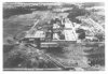
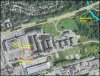
jane pitfield's book leaside says that the last of the airfield hangars was removed in 1971
the airfield was built in 1917 with 45 miles of field tiles to drain the area, which extended north from wicksteed across eglinton to broadway, and west from the don valley across laird to sutherland
see http://books.google.ca/books?id=zli...&pg=PT44#v=onepage&q=leaside airfield&f=false
That's exceptionally useful info, r937 - thank you.
I must get that book.
I wonder how much of the drainage system is still to be found under all that real estate.