
 1.2K
1.2K 


While underused land is quickly being snatched up in Toronto for new density, City initiatives are also in place to improve the quality of life of its residents. Creating new parks and public spaces is one such way, but it's not easy to find unencumbered land in a city that is 'built out, and up' and as a result, designers have to look at spaces creatively, including those which many would consider marginal, and in this case even the space under existing road infrastructure.
The award-winning Underpass Park, a Waterfront Toronto initiative the first phase of which was completed in 2012, responded to the need to build a neighbourhood park and a city-wide destination in a rapidly redeveloping area. The park is sited directly underneath the Richmond, Adelaide, and Eastern Avenue overpasses which link to the Don Valley Parkway. Designed by Vancouver landscape architects Phillips Farevaag Smallenberg and Toronto’s Planning Partnership, Underpass Park was the first piece to open as part of the transformation of West Don Lands into a new mixed-use precinct, and it is an imaginative solution for how to creatively revitalize a derelict site. Designers are able to manipulate the groundscape by building up the topography in order to create an experiential range for residents in what is otherwise a very flat area. At Underpass Park, the cars and structure above do not define the park; instead, spaces are carved out below for different activities: zones for play, seating, and plantings. It is activities and infrastructure coming together.
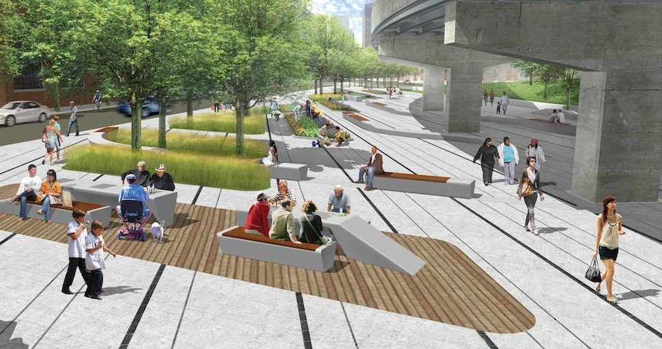
This second phase of the park, west of St. Lawrence Street, grows outwardly from under a maze of concrete ramps from the elevated roadways. Spaces have been planned to accommodate community events, such as local festivals and farmers markets, and even a future community garden. The park's second phase is under construction and expected to open this spring. Photos from late March of the nearly completed expansion were provided by UrbanToronto forum member rdaner.
Below is an image of what Underpass Park Phase 2 will look like when completed. As a key component of the redevelopment of the area, the park will be about inspiring civic space, flexible uses, play, and sustainability.
At the same time, just north of the sheltered skate park in the first phase of Underpass Park, a woonerf is being completed which will transition the park area to the River City condominium complex. A woonerf, a term meaning living street in Dutch, is a driveway paved in such a way as to invite pedestrian use while encouraging drivers to slow down.
Want to know more about Underpass Park? The UrbanToronto dataBase entry for the project includes many more renderings showing how it will look, while earlier articles contain many images of the first phase in use last year. You can find that though the links below, where you can also choose the Projects and Construction Forum thread link to get in on the conversation.


