
 7.8K
7.8K 


Last week, the City hosted a PATH Master Plan public meeting to present the lastest updates and invite the public to contribute their thoughts before the study is complete and its guidelines are written out. The public meeting, as well as the detailed documents available on the City's website for the project, provide a window into the City's desire to more than double the PATH's reach throughout the densest intersections and neighbourhoods. The PATH has grown considerably from the early 1970s when large office superblocks began to emerge, and currently stands at about 30 kms of pedestrian routes. The City hopes to expand that to 60 kms in the future.
An outline of the future vision can be seen below. The original diagram can also be found in the City's display panels here.
The future diagram shows one below-grade knockout panel for 300 Front St and RCMI, and two for Shangri-La. At this time there are no immanent connections that planners could discuss for these three buildings, but there looks to be potential for future tunnels when a desire exists create those connections. The Metro Toronto Convention Centre also seems to have a below-grade knock out panel on Front Street, positioned such that it could conceivably connect directly under the street with the tunnel connecting the CBC building to Simcoe Place.
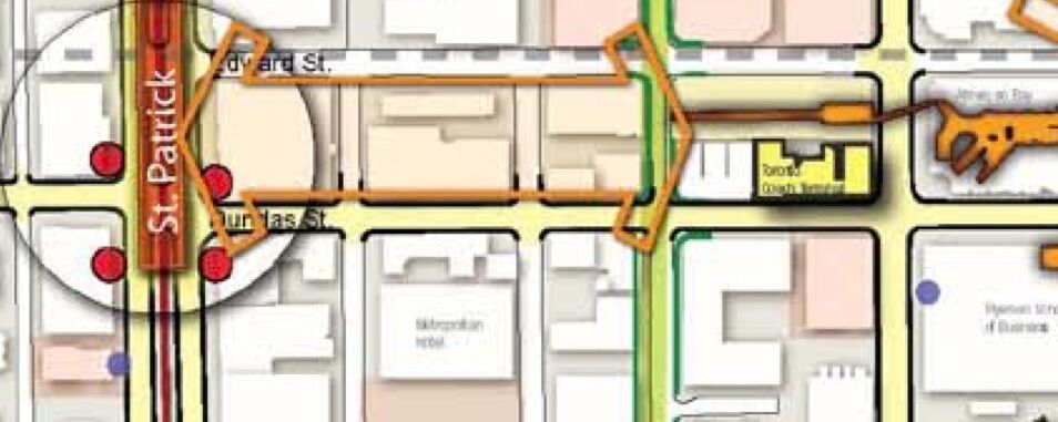
The City has a medium priority vision to connect the Convention Centre to Metro Hall along the John Street corridor, as well as a connection between St. Patrick Station with the Coach Terminal on Bay street along a Dundas Street corridor.
The City still wants Trump Tower connected to the PATH, similar to how One King West is connected through a discrete doorway, but there was no updated news on any ongoing discussions. Bay Adelaide Centre has a below-grade knock out panel on Bay Street facing west, and the City has a low priority long term vision to connect that complex to the Richmond Adelaide Centre. The Four Seasons Centre also has two below-grade knock out panels with a medium priority vision to create connections south to the Hilton Hotel, and east to the Sheraton Hotel.
Maple Leaf Square shows not one but two bellow-grade knock out panels. When asked about it, only the one on the west side connecting to ICE was imminent. The map shows a second panel on the south wall closer to the York Street intersection, but there are no ideas for what a second subterranean connection would look like, and in which direction it would go. Could this provide another future connection south towards the 90 Harbour Street redevelopment, on top of the already planned above grade bridge connection from the ACC? Dashed lines in the following diagram are high priority connections, most of which are known designs or concepts, and are expecting construction in the near future. The map also shows above grade knock out panels at both the ICE and Infinity complex, showing a potential connection on south side of properties. Planners were talking about likely a bridge, or a street level pathway with one side glass wall, much like the short connection at Union Station between ACC and Telus building.
Moving east, the map shows a connection between Union Station, above grade towards the Backstage Condo area. Sony Centre was in discussion for potentially connecting themselves to the PATH, but have since pulled out and are no longer actively pursuing such a connection. Medium priority connections have Backstage connecting further east through the large parking structure on the north side of the rail corridor, up towards the Church Street terminus, as well as another connection from BCE Place towards Berczy Park. Another medium priority vision is to have a major connection between the Yonge and Esplanade area, towards Queen's Quay using Yonge Street as the corridor.
The Northwest PATH tunnel is the City's largest contribution to the tunnel system. Design drawings are close to completion, with construction beginning soon. The City would like to see the first part of the tunnel complete by end of 2012, with the full tunnel up to Wellington open by 2014.
Another interesting part of the future vision is up at College and University, in the hospital and Discovery District area. Currently there is a little known private tunnel system under Gerrard Street linking three hospitals, recently covered in an UrbanToronto article on a MaRS Phase 2 connection to Queen's Park subway station. These tunnels are not advertised as public walkways and are currently used only by hospital staff. Both the City and the hospitals have shown a great desire to be linked to the PATH system, however because the hospitals currently don't have the kind of funds necessary to properly create those linkages there is currently no indication as to whether a north/south or east/west connection is more likely to happen in the near future. The MaRS Discovery District buildings already have a concourse level path system built in an east/west direction parallel to College St., with Phase 2 continuing that concourse in a north/south direction parallel with University Avenue. The City would like to see a medium priority connection between MaRS and College Park.
Part of the study is focused on appropriately designed grade-level portals, and examples are drawn from a number of worldwide cities. The goal of the future PATH system is not just to link more buildings and public facilities, but also to connect with nearby public spaces and parks, such as Berczy Park and the Queen's Quay/Waterfront area for example. As such, we may see more stand alone portal entrances, and it becomes increasingly important to focus on their designs.
The City is also exploring multiple types of pedestrian connections that are most appropriate to the immediate neighbourhood environment, and they include both above grade and at grade connections. They also want to provide pedestrian oriented streetscapes that support pedestrian connections between PATH portals and other important destinations further away.
The City is also interested in defining future PATH satellite districts such as the College Street district, the Yonge and Bloor area, Yonge and Eglinton, as well as North York Centre, all of which currently have a few below-grade connections, but no coherent plan to guide potential future extensions.
Current PATH system, by the numbers:
- Close to 30 km of pedestrian tunnels, concourses, walkways, bridges, and retail arcades.
- More than 125 grade level access points.
- Over 100,000 pedestrians use the system each day.
- Provides a link to: City Hall, grocery stores, 3 schools, 5 condos, 5 subway stations, 6 hotels, 6 cultural sites, over 50 office towers.
- 1200 stores (1000 in underground PATH, plus upper levels of Eaton Centre)
- 4 million sq. ft. of gross leasable retail space (3 million sq. ft. in underground PATH, plus the upper levels of Eaton Centre and the Bay)..
- $1.5 billion in sales revenue generated.
- $126 million in employment income generated.
- $254 million in income, sales, and property tax contributions.
- The largest underground shopping complex, according to the Guinness Book of World Records.
- If the PATH system were a single mall, it would rank high on the list of the world's largest malls as well.


